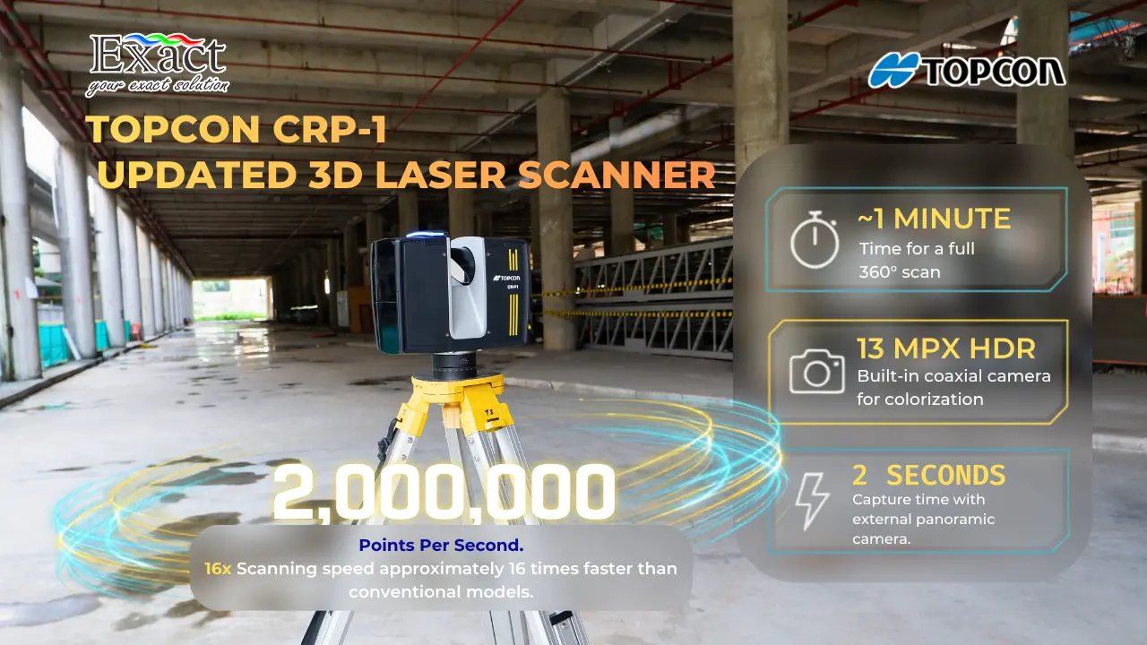
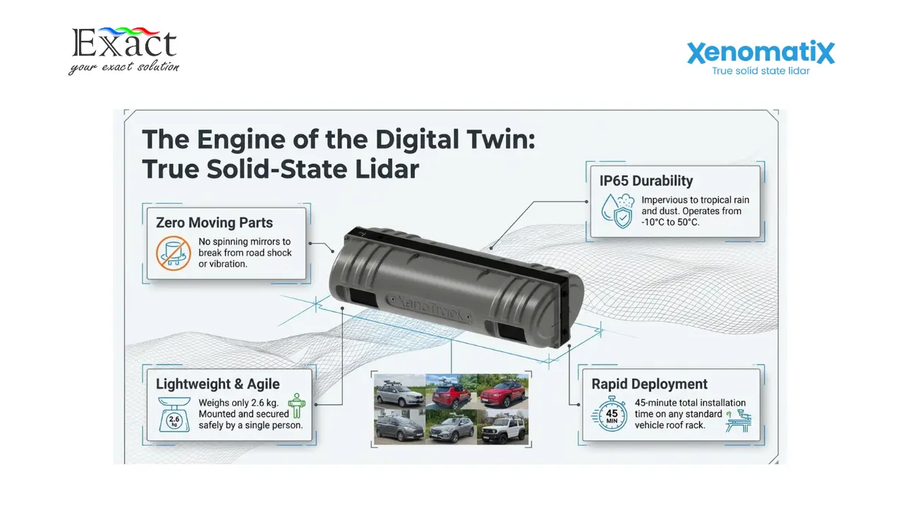
Artikel dan Berita

Homepage > Artikel dan berita

The Ultimate Guide to Ground Penetrating Radar Frequency: Why the Flexible 30MHz Antenna is the Best Solution for Deep Penetration in Extreme Terrains

The Ultimate Guide to Ground Penetrating Radar Frequency: Why the Flexible 30MHz Antenna is the Best Solution for Deep Penetration in Extreme Terrains

The MALÅ Rough Terrain Antenna (RTA) 30MHz is a specialized Ground Penetrating Radar (GPR) solution engineered for deep subsurface investigations in challenging environments like thick…

Tips for Choosing a Professional Geoelectrical Service: Why ABEM Terrameter LS 2 is the No. 1 Choice in Indonesia

Tips for Choosing a Professional Geoelectrical Service: Why ABEM Terrameter LS 2 is the No. 1 Choice in Indonesia

Selecting a professional geoelectrical service is critical for the success of major projects, requiring uncompromised data accuracy and high-resolution results for tasks such as groundwater…

Accelerating Nickel Laterite RKAB 2026: Why “Walking TEM” is the Key to Efficiency in Indonesia’s Extreme Terrain

Accelerating Nickel Laterite RKAB 2026: Why “Walking TEM” is the Key to Efficiency in Indonesia’s Extreme Terrain

The ABEM GroundTEM Trek is a revolutionary "Walking TEM" solution designed to help mining companies in Indonesia meet the urgent RKAB 2026 deadlines and strict…

The Walking TEM Revolution in Indonesia: How ABEM GroundTEM Trek Accelerates Subsurface Mapping by 10x

The Walking TEM Revolution in Indonesia: How ABEM GroundTEM Trek Accelerates Subsurface Mapping by 10x

The ABEM GroundTEM Trek, represented by PT. Exact Global Teknologi, introduces the "Walking TEM" era, enabling subsurface mapping that is 10 times faster by eliminating…

Official Distributor of ABEM GroundTEM i-Series Indonesia: Fastest Groundwater & Mineral Survey Tool — Finishes 5 Points/Day!

Official Distributor of ABEM GroundTEM i-Series Indonesia: Fastest Groundwater & Mineral Survey Tool — Finishes 5 Points/Day!

Official Distributor of ABEM GroundTEM i-Series Indonesia: Fastest Groundwater & Mineral Survey Tool As we prepare for Mineral Deposit Exploration 2026, field efficiency and data…

Optimizing Deep Aquifer Exploration in Indonesia: Accuracy Analysis of Transient Electromagnetic Method (TEM) vs Resistivity

Optimizing Deep Aquifer Exploration in Indonesia: Accuracy Analysis of Transient Electromagnetic Method (TEM) vs Resistivity

As Indonesia’s infrastructure grows, the transient electromagnetic method in indonesia has become the gold standard for subsurface mapping. Traditional resistivity often struggles with the archipelago’s…

Optimizing Utility Mapping: Combining GPR & RD8200 for Accurate Detection (Available in Indonesia)

Optimizing Utility Mapping: Combining GPR & RD8200 for Accurate Detection (Available in Indonesia)

Underground infrastructure in major Indonesian hubs like Jakarta and Surabaya is becoming more congested every day, leading to a recurring risk of buried utility strikes.…

RD8200 vs. RD8200G: Technical Specification Comparison – Which Utility Locator is the Smarter Investment?

RD8200 vs. RD8200G: Technical Specification Comparison – Which Utility Locator is the Smarter Investment?

Eliminate blind spots in subsurface utility mapping with the synergy of GPR and the RD8200 series. Learn our proven 3-phase methodology to accurately locate PVC…

Jakarta’s Sidewalk Utility Mapping Solution with a Compact 3D GPR ArrayJakarta’s Sidewalk Utility Mapping Solution with a Compact 3D GPR Array

Jakarta’s Sidewalk Utility Mapping Solution with a Compact 3D GPR ArrayJakarta’s Sidewalk Utility Mapping Solution with a Compact 3D GPR Array

Traditional single-line GPR methodologies rely on a back-and-forth grid pattern, which inherently creates "blind spots" in the blank spaces between survey lines. The MIRA Compact…

Stop Guessing Where the Pipes Are: Why Jakarta’s Sidewalk Projects Must Adopt 3D GPR in Indonesia

Stop Guessing Where the Pipes Are: Why Jakarta’s Sidewalk Projects Must Adopt 3D GPR in Indonesia

The Challenge: Jakarta’s Narrow Paths and "Blind" Maps Mapping underground infrastructure in dense urban environments like Jakarta is a high-stakes challenge. Existing utility maps are…

Stop Buying Fragile Scanners: Why XenoTrack is the Best Investment for a Mobile Mapping System product in Indonesia?

Stop Buying Fragile Scanners: Why XenoTrack is the Best Investment for a Mobile Mapping System product in Indonesia?

We must stop buying fragile scanners that cannot handle real-world conditions. Discover why the true solid-state XenoTrack is the most logical investment for a Mobile…

Preventing Fatal Losses: Millimeter-Level Accuracy of Mobile Mapping Systems for Road and Runway Inspection in Indonesia

Preventing Fatal Losses: Millimeter-Level Accuracy of Mobile Mapping Systems for Road and Runway Inspection in Indonesia

Relying on fragile, outdated scanners for infrastructure inspection puts your project budgets and public safety at immense risk. Discover how upgrading to a true solid-state…

Translate »