Managing airport infrastructure is a heavy responsibility. Every day, thousands of lives rely on the exact condition of our runways. When an aircraft lands, the pavement absorbs a massive impact. Over time, these heavy traffic loads and harsh weather conditions break down the pavement surface. For those of us managing these assets, balancing strict safety regulations with limited maintenance budgets is our main priority.
In the past, we relied on human inspectors to walk the runway. They used tape measures, rulers, and visual estimates to find problems. This manual method is slow, dangerous, and highly subjective. A human eye cannot accurately measure the depth of a hidden subsidence or the exact volume of a pothole. Today, international aviation safety demands exact mathematical proof. We must prove our surfaces are flat, provide high friction, and have no severe defects.
To achieve this, we must adopt an advanced Airport Runway LiDAR and Runway Defect Detection Equipment. By mounting a true solid-state laser system onto a standard vehicle, we can digitize the entire runway at high speeds. This gives us the exact data we need to fix small problems before they force us to close the runway for massive, expensive repairs.
Here are the ten ways we use a Mobile Mapping System to monitor our infrastructure, protect our budgets, and ensure total safety.
Stopping the Financial Drain with Preventive Maintenance
A runway follows a very specific deterioration curve. For the first 10 to 15 years after we build it, the pavement stays in excellent condition. However, once the foundation starts to weaken or the top layer opens up, the decline happens rapidly. If we miss this critical window, water gets inside the foundation. This speeds up the destruction of the pavement, especially during heavy rain. Once the runway fails, we have to pay for a total reconstruction, which drains our entire budget.
We can stop this financial loss by performing preventive maintenance. Industry studies prove that every single dollar we spend on early preservation saves us up to six dollars in heavy rehabilitation later. By repairing the pavement early, we reduce the total cost of ownership by 25% to 30%. To do this, we need to take a periodic snapshot of the runway. By scanning the surface regularly, we know exactly where the pavement sits on its lifetime curve. We can then spend our limited funds strictly on the sections that are about to enter their rapid decline.
Ensuring Strict ICAO Annex 14 Compliance
International standards dictate how we must maintain our airports. Under these rules, we must guarantee that our runways do not have dangerous slopes, hidden water-pooling areas, or severe cracks that could create Foreign Object Debris (FOD). Manual inspections make it impossible to prove this compliance objectively. If an inspector writes down that a crack looks “medium,” we do not have hard data to back up that claim.
By using an advanced Mobile Mapping System, we replace human guesswork with objective, numerical data. The system uses a true solid-state Lidar that captures over 1.12 million measurement points every single second. It measures the runway with a single laser accuracy of 0.23 millimeters. This allows us to prove our ICAO Annex 14 Compliance to any auditor. We can show them the exact geometric data of the entire runway, leaving no room for argument or doubt.
Monitoring the International Roughness Index (IRI)
Pilots complain immediately if a runway feels wavy or bumpy during landing or take-off. Uneven surfaces make the aircraft shake, which puts extreme stress on the landing gear. To classify the smoothness of our pavement, we use the International Roughness Index (IRI). This index is influenced by a wide range of surface damages, including undulations, subsidences, and peeling.
We measure the IRI by scanning the surface locally from gutter to gutter. The Lidar system measures the exact height of the pavement, identifying areas where the surface is sinking below the average level or sticking out. We calculate the waviness parameters (such as the 2.5-meter waviness and 10-meter waviness) to find the specific patterns causing the rough ride. This data helps us rank the quality of our runways and prioritize which sections need immediate resurfacing.
Tracking the Pavement Condition Index (PCI) Accurately
The Pavement Condition Index (PCI) is the ultimate scorecard for our infrastructure. It combines all the different types of damage into one overall health score. However, calculating a correct PCI requires us to find and measure every single crack and pothole across millions of square meters of asphalt. Doing this manually is impossible.
We solve this by using the Digital Road Plus (DRP) software module. This system automatically calculates the exact metrics required for our PCI scoring. It uses high-resolution geometrical data to quantify crack severity and density according to the exact rules of the ASTM E3303 standard. We split the digital runway into specific assessment zones. The software then applies different weights to different types of damage, giving us a completely objective PCI score that we can trust for our long-term planning.
Creating a High-density Point Cloud for a Digital Twin Runway
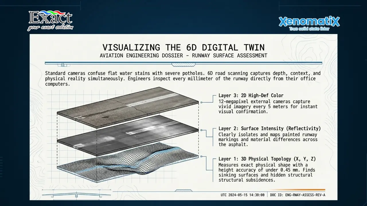
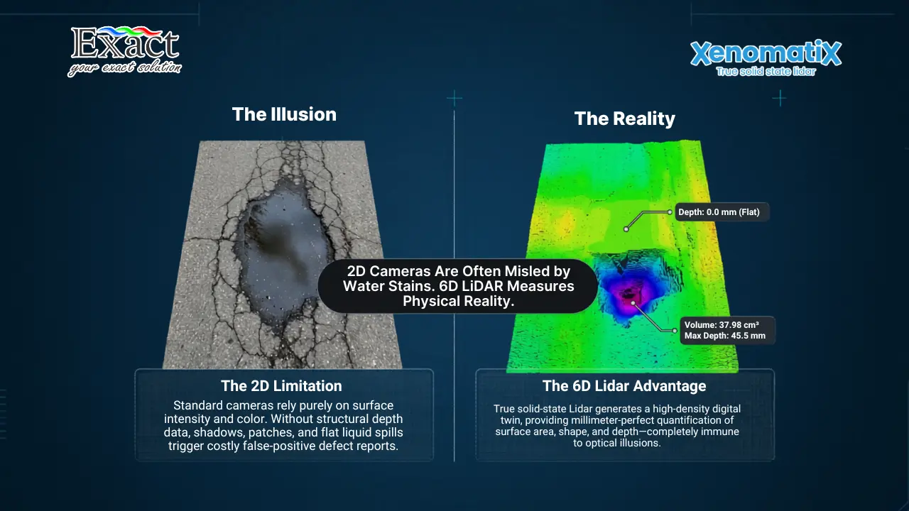
Simple camera pictures are not enough to manage an airport. A standard camera cannot measure depth, which means it easily confuses a dark, flat water stain with a real pothole. To fix this, we build a complete Digital Twin Runway. We use a method called 6D road scanning.
This 6D method records six different dimensions of data at the same time. First, we capture the 3D physical shape of the runway (the X, Y, and Z coordinates). Second, we record the surface intensity, which clearly shows our painted runway markings. Finally, we record 2D high-definition color images every 5 meters using a 12-megapixel external camera. We merge all this data into a massive High-density Point Cloud. This digital twin allows our engineering teams to inspect every millimeter of the runway directly from their office computers.
Mapping Defects with Perfect Georeferencing
When our system finds a defect, we must tell our repair crews exactly where to go. Sending a crew out to find a specific crack on a 3-kilometer runway wastes time. We solve this through precise Georeferencing.
Our Lidar equipment connects directly to RTK GNSS antennas mounted on the vehicle roof. Every single measurement point, every crack, and every pothole is tied to an exact global GPS coordinate. The processing software exports the data in standard Shapefile (.SHP) and XML formats. We can drag and drop these files straight into our existing Geographic Information System (GIS) or Pavement Management System (PMS). The map clearly displays color-coded lines, showing the repair teams the exact geographic location of the damage.
Inspecting Safely Without Closing the Runway
Closing an active runway for an inspection causes massive flight delays and costs the airport heavy financial losses. Furthermore, having personnel walk on active tarmac areas creates a severe safety risk.
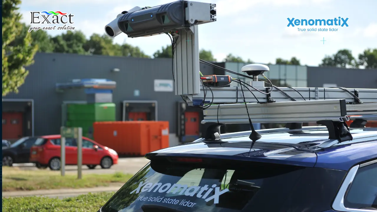
Our mobile Lidar approach eliminates both of these problems. The equipment, such as the XenoTrack sensor, easily mounts to the roof rack of a standard airport operations vehicle in just 45 minutes. Once the rigid bar is secure, the inspector simply drives down the runway. We capture all the data while driving at normal operational speeds, up to 100 or 120 km/h. We never block traffic, we never cause delays, and we keep our personnel safely inside the vehicle at all times.
Providing Exact Data for the Safety Management System
Every modern airport operates a strict Safety Management System (SMS). The goal of the SMS is to manage risk before accidents happen. When dealing with pavement defects, particularly potholes, we must classify the exact severity of the risk.
Our automated pothole detection module removes human error from this process. Because the Lidar emits its own light, we can measure the pavement in total darkness or bright sunlight. The system calculates the exact surface area in square millimeters, the maximum depth, the average depth, and the total volume in cubic centimeters of every pothole. The software then ranks the pothole severity (Low, Medium, or High) based exactly on the ASTM D6433 standard tables. This gives our safety directors the exact numerical proof they need to justify emergency repairs within the Safety Management System.
Measuring Grip for the Global Reporting Format
When it rains, runways must have the correct amount of grip to stop heavy aircraft from skidding. Traditionally, testing this friction required a special, heavy truck that dumps water on the runway and measures the slip of a specific friction wheel. This old method is incredibly expensive and only measures a single, narrow line of the pavement.
Under the new Global Reporting Format for runway surface conditions, we need better data. We use a high-resolution optical approach to determine friction. Friction is largely determined by the macro-texture of the pavement surface. Our Lidar measures the road surface locally with an extreme resolution of under 50 micrometers and an accuracy of under 0.2 millimeters. This allows us to calculate the macro-texture according to the ASTM E1845-15 standard. We can monitor runway grip more often and across the entire width of the landing zone, keeping our aircraft much safer.
Using Edge-AI and True Solid-State Hardware
Airports are secure environments. We cannot upload massive files of critical infrastructure data to public cloud servers just to process our PCI scores. Our system handles this locally using Edge-AI. We use a heavy-duty computer called the X-Controller. It features a 6-core NVIDIA processor and a 384-core GPU. This computer processes all the heavy Lidar and camera data right inside the vehicle, separating longitudinal, transversal, and block cracks instantly.
Furthermore, we stop wasting money on fragile scanners. Old laser systems use spinning mirrors inside. When the inspection car hits a bump, those moving parts break. We only use true solid-state Lidar. The sensor has zero moving parts inside. It holds an IP65 protection rating against water and dust. It operates perfectly in extreme temperatures from -10 °C up to 50 °C.
To implement this advanced hardware, we work directly with a local Distributor Xenotrack-Xenomatix. This ensures our airport staff receives the correct installation, thorough software training, and immediate technical support.
Frequently Asked Questions (FAQ)
What is the Airport Runway LiDAR and Runway Defect Detection Equipment?
It is a vehicle-mounted technology that uses true solid-state Lidar and high-definition cameras to scan the runway surface. It captures a 6D digital twin of the pavement, including 3D geometry, 2D color images, and surface intensity, all perfectly linked to precise GPS coordinates.
How does this system help us maintain ICAO Annex 14 Compliance?
By replacing subjective human visual checks with highly accurate mathematical data. The system generates high-density point clouds with a height accuracy of under 0.45 millimeters. This provides objective proof that the runway is flat, has no dangerous pooling areas, and meets all regulatory standards.
Do we need to close the runway or halt air traffic to perform the scan?
No. The system operates from a standard vehicle driving at normal operational speeds (up to 120 km/h). There is no need to walk the runway, close the facility for extended periods, or put personnel at risk.
How does the system calculate the Pavement Condition Index (PCI)?
The system uses the X-Controller Edge-AI computer to identify and measure defects automatically. It separates cracks by type (longitudinal, block, alligator) and calculates their exact width and length according to ASTM E3303. It also measures the exact volume and depth of potholes according to ASTM D6433. These metrics are then combined to generate the final PCI score.
Can the system measure runway grip and friction?
Yes. Instead of using a traditional water-tank truck, our optical approach measures the macro-texture of the pavement surface. By scanning the surface roughness at a resolution of under 50 micrometers, we determine the friction levels based on the ASTM E1845-15 standard, aiding in Global Reporting Format compliance.
Is our data secure, or do we have to upload it to the cloud?
Your data remains entirely under your control. The system relies on Edge-AI processing directly inside the vehicle. You do not need to transfer your critical infrastructure data to an external cloud server to detect cracks or calculate your International Roughness Index.
Protect Your Runway. Prevent Fatal Losses Today. For advanced runway inspection services, equipment demonstrations, and consultation on implementing a digital twin for your airport, please reach out to our dedicated team.
Exact Global Teknologi
Website: www.exactglobal.co.id
Email Marketing: marketing@exactglobal.co.id
WhatsApp: +62 812-9252-3900