When we conduct subsurface surveys, we face many environmental and technical challenges. We often need to look deep into the earth while working in thick forests, rocky mountains, or uneven landscapes. To get the best results, we must understand the core principles of radar technology and use equipment built for tough conditions.
In this comprehensive guide, we will explore the Relationship Between Ground Penetrating Radar Frequency and Depth Penetration. We will also look at why the MALÅ Rough Terrain Antenna (RTA) series, specifically the 30MHz model, is our ultimate choice for deep geological surveys.
Here are seven reasons why the flexible 30MHz antenna stands out as the best solution for deep penetration in extreme terrains.
Understanding the Relationship Between Ground Penetrating Radar Frequency and Depth Penetration
 To get the right data, we must choose the right frequency. The basic rule of Ground Penetrating Radar (GPR) is that frequency determines both how deep we can see and the level of detail we receive. Higher frequencies (like 500MHz or 800MHz) give us excellent resolution for shallow targets, such as road pavements or utility pipes. However, their signals run out of energy quickly and cannot travel deep into the ground.
On the other hand, lower frequencies have longer wavelengths that can push through dense soil and rock layers. When we need to see far beneath the surface, we rely on low-frequency antennas. The MALÅ RTA 30MHz is specifically designed for investigations requiring the deepest possible depth penetration. By understanding the Relationship Between Ground Penetrating Radar Frequency and Depth Penetration, we can confidently deploy the 30MHz antenna when our project demands maximum depth rather than tiny, shallow details.
Powerful Capabilities in Depth to Bedrock Mapping
Because the 30MHz frequency travels deeper than standard antennas, it opens up a whole new world of survey applications. We find it incredibly useful for deep geological layer investigations.
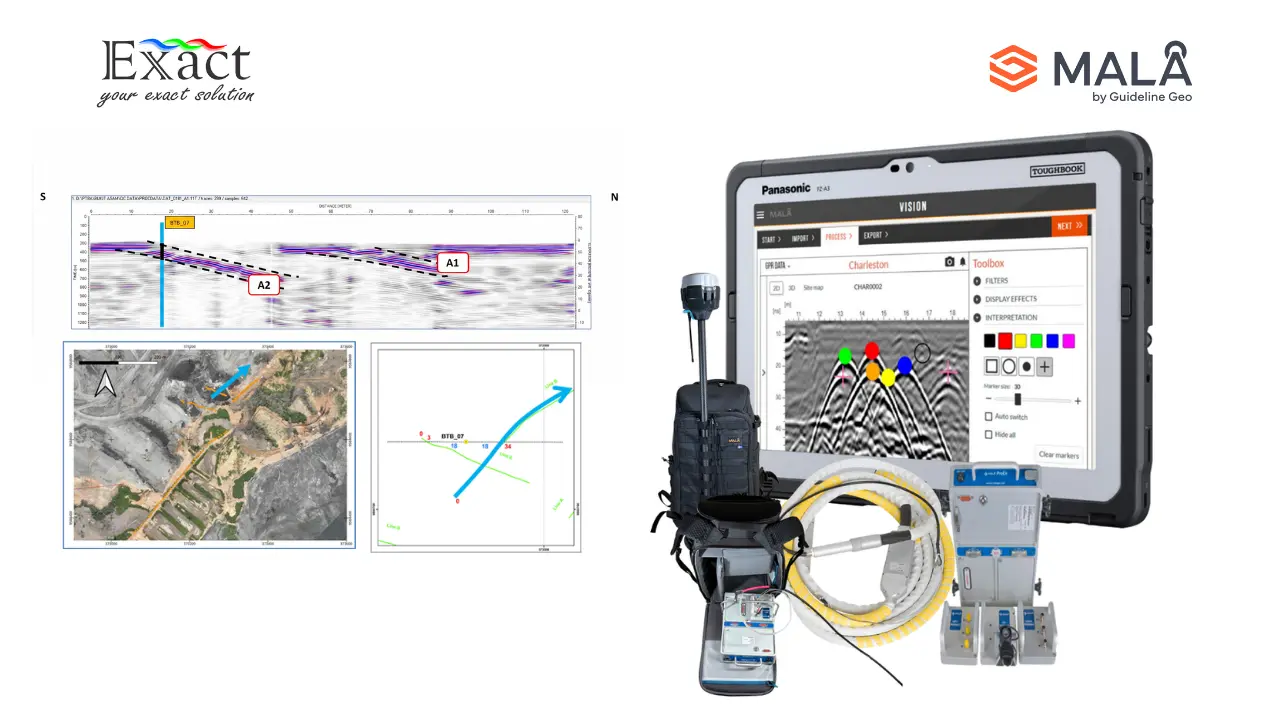
One of the most important uses for the 30MHz antenna is depth to bedrock mapping. Engineers and geologists need to know exactly where the solid bedrock begins before starting large construction, mining, or drilling projects. The low-frequency signal easily penetrates soil, sand, and clay to bounce off the hard bedrock layer below. Furthermore, we frequently use this exact 30MHz equipment for advanced glaciology studies (measuring ice thickness) and the mapping of deep groundwater resources.
Breaking Barriers with a Design Unshielded Radar Antenna
Traditional GPR antennas usually come in heavy, rigid boxes. While box antennas work well on flat roads, they are nearly impossible to drag through a thick forest. To solve this, MALÅ changed the face of low-frequency GPR surveying by creating a completely different physical structure.
The RTA series features a one-piece, design unshielded radar antenna where the antenna elements are mounted in a unique in-line configuration. Instead of a stiff box, the antenna looks and moves like a thick rope or a snake. To ensure it survives the harshest environments, the internal fiber optic cables are reinforced with strong Kevlar, and the connections feature heavy-duty stainless steel and ceramic tips.
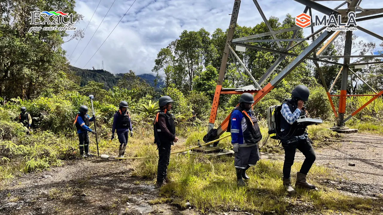
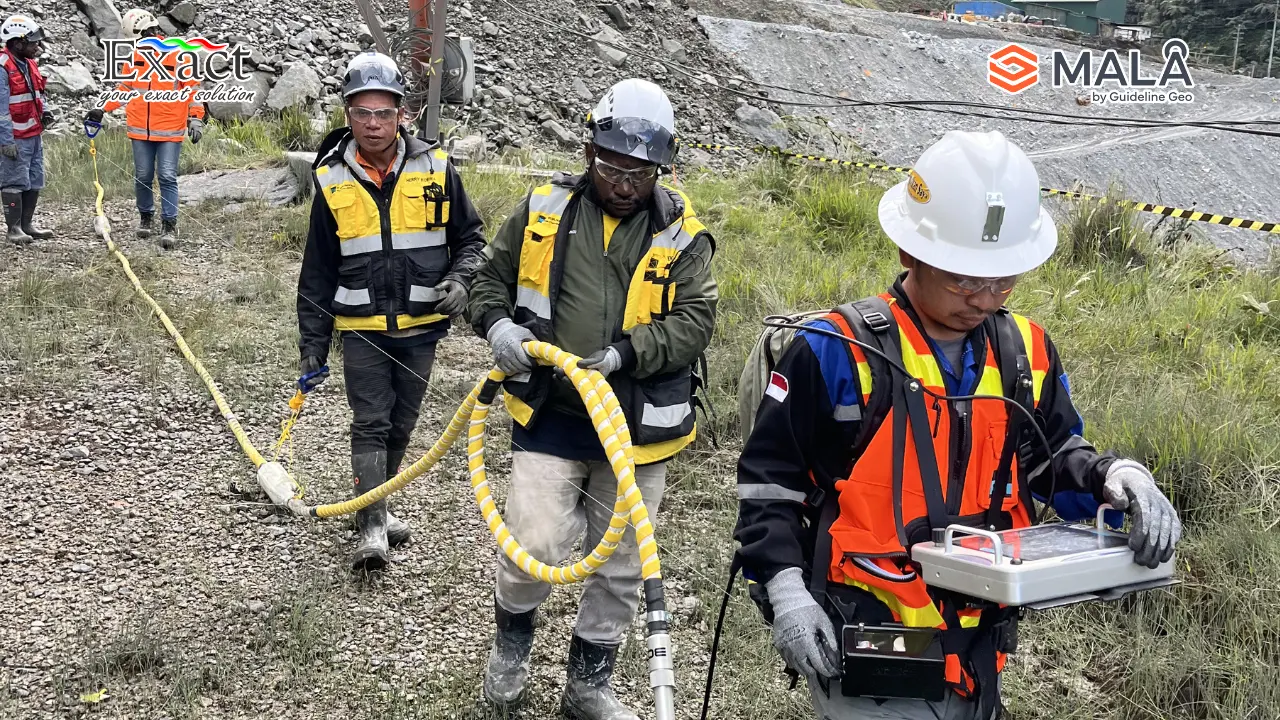
Conquering Extreme Terrains Without Clearing Paths
When we survey in the wilderness, the terrain is rarely flat. We often encounter dense vegetation, rocks, and uneven ground. If we use standard equipment, the rigid antenna boxes bounce off rocks and lose contact with the soil, causing poor data quality.
The flexible “snake-like” design of the RTA allows the antenna to be maneuvered easily and efficiently through the densest or most uneven terrain. Because the antenna is entirely flexible, it hugs the ground naturally, ensuring we maintain stable ground contact for optimal radar results.
The most important benefit we get from this design is that we do not have to clear an access path or route prior to running our survey profile. The flexible antenna simply slides around bushes, trees, and rocks as we pull it along.
Achieving Massive Manpower Cost Reduction
Clearing survey lines with machetes and chainsaws takes days and requires a large team of workers. By using the 30MHz RTA, we completely eliminate this step.
Because we no longer need to chop down brush or flatten the path, we see a dramatic drop in the time it takes to complete a project. Existing users of the MALÅ RTA report reductions in survey time and manpower requirements to a third of those experienced when using traditional unshielded antennas. This incredible manpower cost reduction makes the RTA not only a powerful technical tool but also a highly profitable investment for our surveying business.
Seamless Integration with Multi-Channel Data Collection
Modern surveying often requires us to look at the ground in multiple ways at the same time. We connect the 30MHz RTA to the MALÅ Professional Explorer (ProEx) Control Unit, which is the most versatile GPR system on the market.
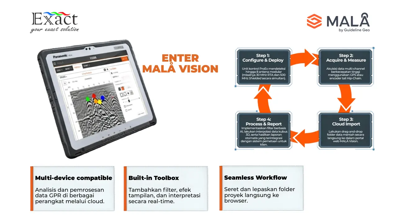
The ProEx system features a modular design that supports multi-channel data collection. In its base form, the unit handles two hardware channels, but we can add ProEx Expansion Units to support up to eight individual antennas at once. Because the ProEx uses multiple processors, it maintains a massive data acquisition rate regardless of how many data channels we use. We can easily run the 30MHz RTA for deep bedrock alongside a higher frequency antenna to map shallow utility lines simultaneously.
Partnering with a Reliable Distributor MALÅ GPR RTA
To guarantee that our field operations run perfectly, we must source our equipment from a trusted supplier. Working with an authorized Distributor MALÅ GPR RTA ensures that we get genuine, field-ready equipment with the latest optical modules and heavy-duty Kevlar cables. A reliable distributor also provides the necessary accessories, such as towing belts, skid plates, and hip-chain distance encoders, which are critical for measuring exact distances in trackless wilderness where normal measuring wheels fail.
Frequently Asked Questions (FAQ)
Q: Why does the 30MHz frequency penetrate deeper than other antennas?
A: The Relationship Between Ground Penetrating Radar Frequency and Depth Penetration dictates that lower frequencies have longer wavelengths. These longer waves lose less energy as they travel, allowing the 30MHz signal to push much deeper into the earth compared to higher frequency antennas.
Q: Can the 30MHz flexible antenna be used in the rain or wet swamps?
A: Yes. The MALÅ RTA is built to meet IP65 standards. This means the antenna is completely protected against dust and is safe to use during rain and on wet ground conditions.
Q: How do we measure survey distance if we cannot use a wheel in the thick forest?
A: For trackless and rough terrain where a wheel is impractical, we use the MALÅ standard distance measuring hip-chain (string encoder). It uses a biodegradable cotton string to accurately trigger the radar pulses as we walk.
Q: Does the ProEx system slow down if we connect multiple antennas?
A: No. The MALÅ ProEx was specifically designed for multi-channel data collection. It utilizes multiple processors to ensure the system maintains its high data acquisition rate, even if we expand it to use up to 8 antennas.
Q: Do we need to spend time clearing vegetation before using the RTA?
A: No. The unique design unshielded radar antenna acts like a flexible snake. It maneuvers easily through dense vegetation and uneven terrain without losing ground contact, meaning we do not need to clear access paths.
Contact Us for Your Surveying Solutions For more information about acquiring the MALÅ ProEx system and the flexible RTA 30MHz antenna, please contact our expert team:
Exact Global Teknologi
Website: ww.exactglobal.co.id
Email Marketing: marketing@exactglobal.co.id
WhatsApp: +62 812-9252-3900