Highways and expressways give us freedom. We use them every day, and we expect them to be open, smooth, and entirely safe. Because traffic loads grow heavier each year, our roads break down faster than they did in the past. For those of us managing public or private road networks, keeping our budgets under control while hitting strict performance targets is our biggest daily challenge.
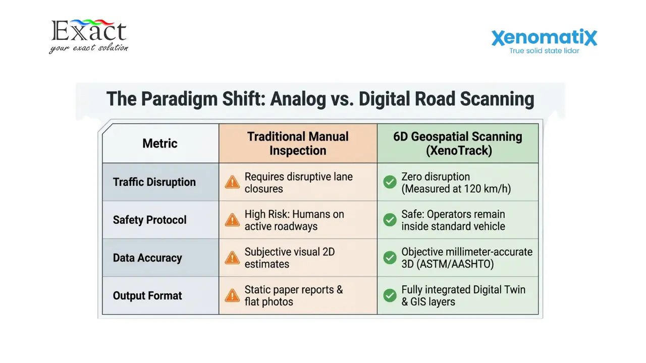
To keep operations running, we have to meet specific regulations. This is where Toll Road Minimum Service Standards come into play. We must prove our roads are flat, free of severe cracks, and provide good grip. However, finding every single defect on a busy highway is difficult. Sending humans to walk along the roadside is slow and dangerous. Using simple cameras does not give us the exact depth of a pothole.
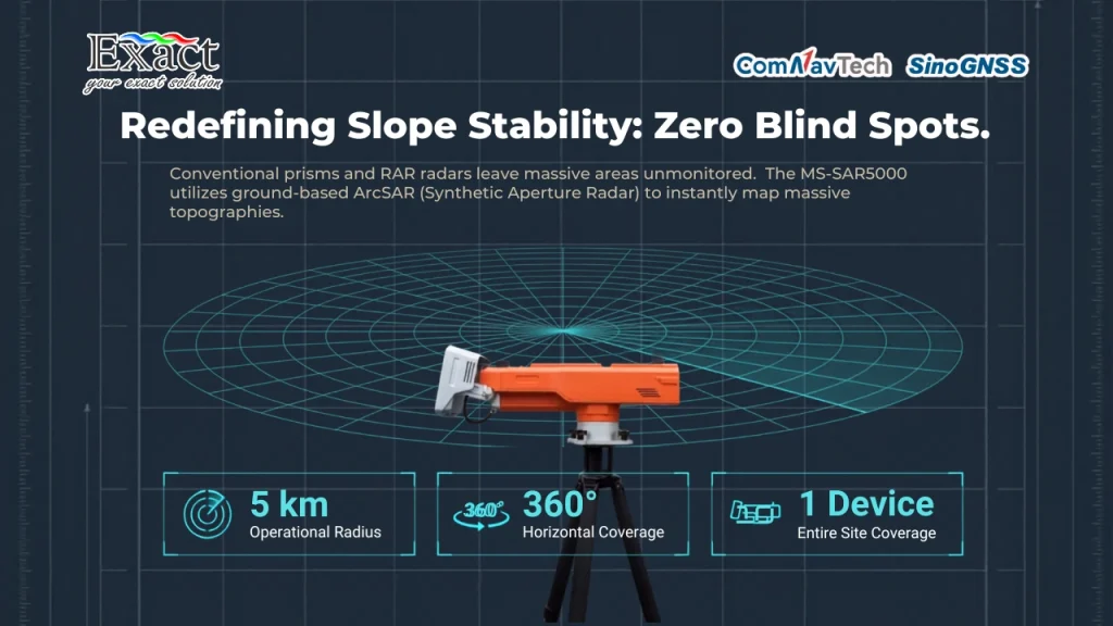
We need a completely new approach. We must perform Expressway Inspection using true 6D road scanning. By capturing exact millimeter measurements from a moving car, we can build a digital twin of the road surface.
Here are ten strategies we use to manage our highways better, protect our budgets, and fulfill our service standards using accurate geospatial data.
Stopping the Financial Drain by Tracking the Pavement Condition Index (PCI)
Roads follow a very predictable deterioration curve. For the first 10 to 15 years after construction, a highway stays in good condition. After that point, the quality drops very fast. If we do nothing, the road hits a phase of accelerated breakdown. Once the road fails completely, we have to pay for a massive, expensive reconstruction.
We save a lot of money when we step in early. Studies show that every dollar we spend on early preservation saves us up to six dollars in heavy rehabilitation later. By catching problems early, we reduce the total cost of ownership by 25% to 30%.
To do this, we monitor the Pavement Condition Index (PCI). This index gives a high weight to severe issues like potholes because they cause fast degradation. By taking a periodic snapshot of our roads, we sample the lifecycle curve and know exactly where every single road stands. We can then spend our limited repair budgets only on the sections that are about to enter the rapid decline phase.
Performing Inspections Without Blocking Traffic
One of the biggest problems with road maintenance is the traffic jam it causes. Drivers hate long, invasive road closures. Furthermore, asking human inspectors to measure lanes with rulers puts their lives at risk from speeding cars.
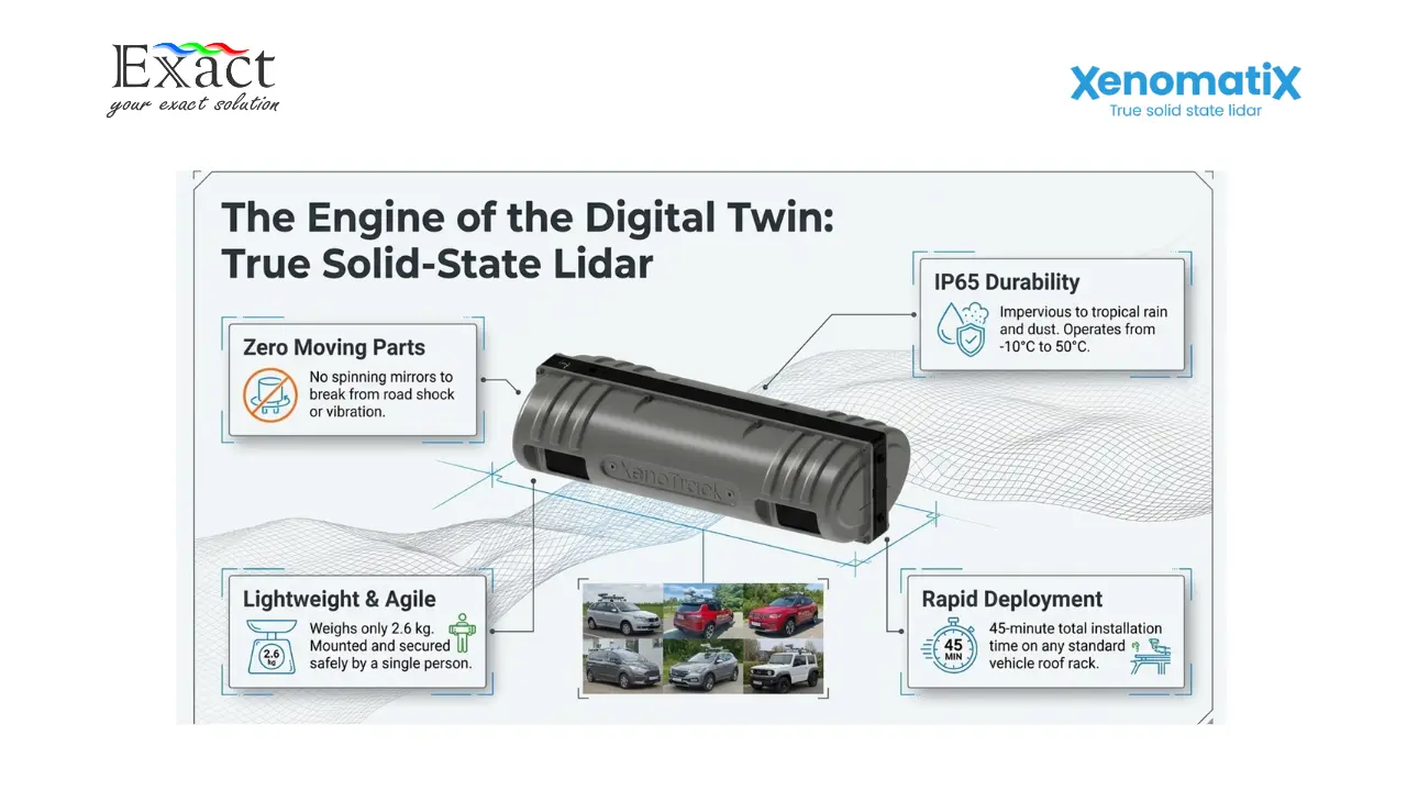
We fix this by using mobile scanning equipment. We mount systems like the XenoTrack true solid-state Lidar directly onto our standard cars or vans. It takes only 45 minutes to install the rigid roof bar. Once the system is secure, we drive at normal highway speeds, up to 100 or 120 km/h. We collect high-resolution data without closing any lanes or slowing down the traffic.
Using True Solid-State Lidar for Durability
If we buy fragile scanners with spinning mirrors inside, they will break when the car hits a bump. Mobile mapping tools take a lot of shock and vibration. We avoid expensive repair bills by using true solid-state Lidar.
Our XenoTrack sensors have zero moving parts inside. They hold an IP65 rating, meaning they are completely safe from dust and water. They work perfectly in hot tropical climates, operating safely in temperatures from -10 °C up to 50 °C. The unit only weighs 2.6 kilograms, so one person can lift and mount it easily.
Improving Road Safety with Accurate Pothole Sizing
Drivers and motorcycle riders do not care much about small cracks, but they care deeply about uneven roads and potholes. Potholes make vehicles bounce, cause tire blowouts, and lower our overall Road Safety.
Standard camera systems fail at pothole detection. A camera lacks depth perception, so it easily confuses a dark, flat water stain with a deep pothole. Lidar fixes this because it physically measures the depth of the road.
Our pothole detection module calculates the exact surface area in square millimeters, the maximum depth, the average depth, and the total volume in cubic centimeters. The software then ranks the pothole severity (Low, Medium, or High) based precisely on the ASTM D6433 standard. Because the Lidar emits its own light, we can find and measure these dangerous potholes in the middle of the night or in bright sunlight.
Automating Crack Detection with Edge AI
Foundation problems are the most destructive issue a road can face. When the foundation breaks, cracks open on the top layer. Water enters these cracks and destroys the road quickly from the inside.
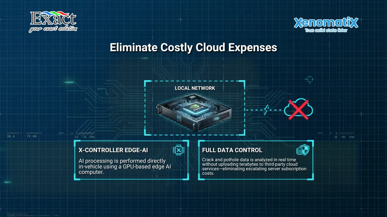
We cannot expect humans to walk thousands of kilometers and manually measure every crack. Instead, we use the Digital Road Plus (DRP) software module for crack detection. The software fuses the 12-megapixel camera images with the 3D Lidar point cloud.
We process all this heavy data right inside the vehicle. We use the X-Controller, a heavy-duty computer powered by an NVIDIA GPU. This Edge-AI processor identifies and separates cracks into specific groups: longitudinal, transversal, diagonal, block, and alligator cracks. We keep full control of our data because we do not have to upload massive files to expensive external cloud servers.
Applying Georeferencing for Precise Maintenance
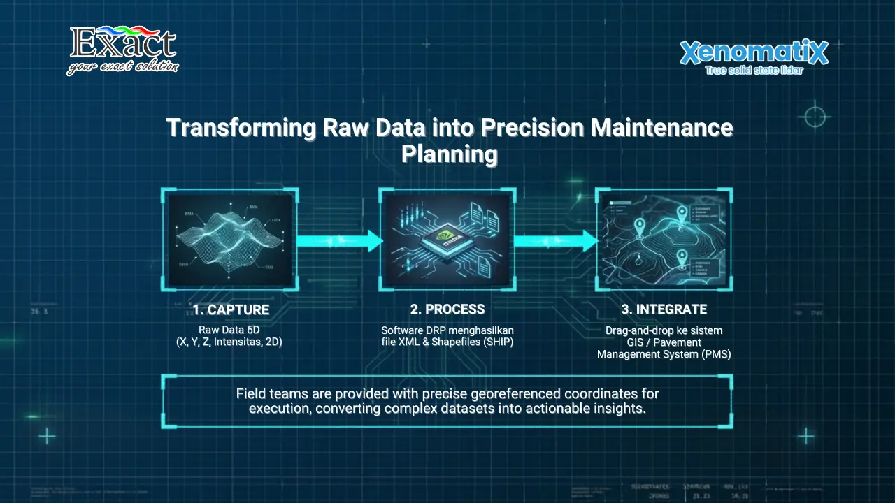
Finding a defect is only helpful if we can tell the repair crew exactly where to go. We record six different dimensions of data: the 3D physical shape (X, Y, Z), the surface intensity, and 2D high-definition color images.
Every single measurement point is tied to exact GPS coordinates. This process, known as Georeferencing, allows us to map the defects perfectly. The crack detection software exports XML files and Shapefiles (.SHP). We drag and drop these Shapefiles straight into our existing Geographic Information System (GIS) or Pavement Management System (PMS). The maps show color-coded lines indicating exactly where the repairs are needed.
Practicing Construction Risk Mitigation on New Asphalt
When we hire a contractor to build or resurface a toll road, the fresh asphalt might look beautiful to the human eye. However, drivers often report shaking and a noisy ride right after the road opens. This waviness happens because of bad foundations, wrong asphalt temperatures, or outdated rolling equipment.
If we only use old-fashioned rulers, we cannot find the exact cause of the problem. To perform proper Construction Risk Mitigation, we digitize the new road. The software checks the specific flatness values over several kilometers, looking at the Vc2.5 (2.5-meter waviness) and Vc10 (10-meter waviness) parameters.
This gives us objective mathematical proof. If the contractor did poor work, we show them the color-coded 3D map. This stops long arguments and ensures we only pay for high-quality asphalt.
Managing Friction and Grip Levels
A toll road must have the correct amount of grip to stop cars from slipping in the rain. Normally, testing this friction requires a special, expensive truck carrying a heavy water tank and a friction wheel. That old method is slow and only tests a single line on the road.
We use an optical approach instead. Friction is strongly tied to the macro-texture of the road surface. By measuring the road locally with an accuracy of under 0.2 millimeters and a resolution under 50 micrometers, we determine the macro-texture. This complies with the ASTM E1845-15 standard. This allows us to monitor road grip more often, across more areas, and keep drivers much safer.
Measuring Bridge Clearances for Heavy Transport
We have to know the exact clearance height under bridges and signs for tall transport trucks. Hitting a bridge causes major structural failures and stops traffic for hours. Walking on a busy highway to measure a bridge is incredibly dangerous.
We use our Lidar systems to create a complete 3D model of the highway and the bridge above it. We can measure the free passage height for every bridge safely. If the clearance is slightly lower on the left side, the 3D model helps us calculate if a tall truck can pass by driving strictly in the right lane. This planning avoids delays, lowers transport insurance costs, and protects our infrastructure.
Finding the Right Equipment and Distributor
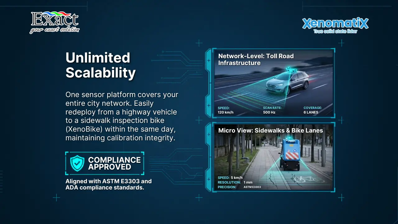
We cannot build a modern maintenance plan using old, broken equipment. To meet strict service standards, we must use the correct scanning hardware. We choose from three specific Lidar models based on our budget and needs:
- Single Lane Model: Covers a 4-meter width with a 5mm by 5mm resolution.
- Dual Lane Model: Covers 7.5 meters to scan two lanes at the same time.
- Front View Model: Points forward to scan obstacles and bridge clearances up to 8.2 meters ahead.
To get this advanced hardware into our fleet, we work with a dedicated local expert. By partnering with the official Distributor Xenomatix in Indonesia, we ensure we get fast technical support, correct installation, and thorough software training.
Frequently Asked Questions (FAQ)
What exactly is Expressway Inspection with 6D road scanning?
It is a process where we mount a true solid-state Lidar and a high-resolution camera on a standard car. We drive at normal speeds (up to 120 km/h) and record the 3D geometry, 2D images, and surface intensity of the pavement, all perfectly linked to exact GPS coordinates.
How does this technology improve our Pavement Condition Index (PCI) scores?
By scanning the highway regularly, we spot small foundation subsidences and tiny cracks before they grow into large failures. Repairing these small defects early stops water from destroying the road base, keeping our overall PCI score high and saving us massive reconstruction costs later.
How does 6D scanning help with Construction Risk Mitigation?
When a contractor finishes a new road, we scan the whole surface to create a digital elevation map. We calculate flatness parameters (VC values) to prove mathematically if the road meets the project specifications. We use this objective data to hold contractors accountable for their work.
Can the system really tell the difference between a dark stain and a pothole?
Yes. Normal cameras fail because they only see 2D color changes. Our solid-state Lidar measures physical depth. It provides the exact surface area, depth, and volume of the missing asphalt, allowing us to rank the danger based on ASTM standards. This drastically improves our Road Safety.
How does Georeferencing work with this system?
The equipment uses an RTK GNSS antenna to link every single measured point to a global coordinate. The software outputs Shapefiles (.SHP) and XML files. We import these directly into our GIS platforms, giving our repair teams a perfect, color-coded map showing exactly where to apply fresh asphalt.
Who provides this equipment locally?
To get full installation, training, and maintenance support, you can contact the official Distributor xenotrack-xenomatix in your region.
Fulfill Your Toll Road Minimum Service Standards Today For expert consultation, live demonstrations, and exact pricing on the best Lidar inspection systems, please reach out to our team.
Exact Global Teknologi
Website: www.exactglobal.co.id
Email Marketing: marketing@exactglobal.co.id
WhatsApp: +62 812-9252-3900