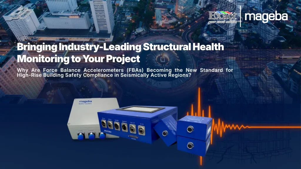
The safety of open-pit mining areas and the protection of workers’ lives are the main pulse of every industrial operation we manage. We understand very well that ground movement and the threat of landslides in excavation areas are geological risks that cannot be underestimated. All this time, our slope monitoring operations have often encountered obstacles because traditional physical contact monitoring methods are difficult to apply and actually put the monitoring tools at risk of destruction due to avalanches. In addition, conventional multi-point monitoring methods are very difficult to use to cover massive topographic areas, so it is very easy for us to miss the most critical crack points in the field. Conventional equipment also often demands complex operation by specialists, while the final results are difficult to visualize.
To solve these systematic problems, ComNav Technology Co., Ltd. designed a cutting-edge instrument called the MS-SAR5000. This device is a professional-grade slope stability monitoring radar system precisely created to perform real-time ground surface displacement measurements. This non-contact radar solution provides early warning of any indication of slope structural failure, securing activities in open-pit mining, construction, and ar as prone to geological disasters.
Let’s dissect the updated specifications of the MS-SAR5000 radar along with its technological advantages compared to its predecessors:
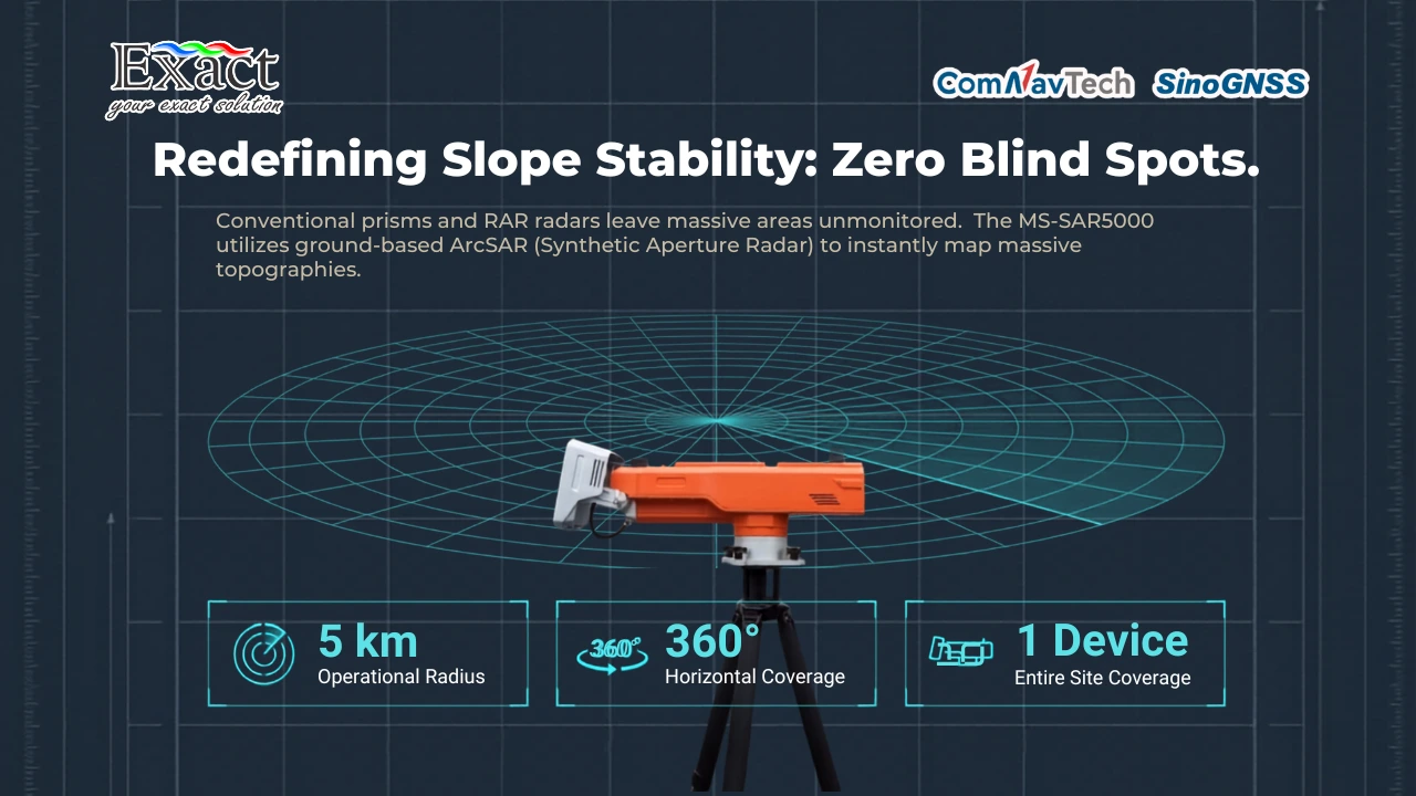
The Advantage of Real Aperture Radar (RAR) vs. Synthetic Aperture Radar (SAR)
The fundamental limitation of our traditional devices is the narrowness of the area that can be monitored. Older generation radars generally use Real Aperture Radar (RAR) technology (information outside the source), which depends on the physical dimensions of the antenna to produce shot quality, making it impractical for monitoring giant mine slopes.
The MS-SAR5000 system leaves this concept behind and shifts to using the technological pillar of ground-based arc SAR (Synthetic Aperture Radar). This ArcSAR technology combines image arrays from various location angles to formulate superior angular resolution. Through this innovation, our radar’s surface vision capability extends extremely with an operational radius ranging from 50 meters up to 5,000 meters (5 km). This long-range reliability is armed with a full 360-degree horizontal angle coverage capability, ensuring surface monitoring takes place without leaving dangerous blind spots. Extra-wide area coverage using a single device significantly cuts our installation and operational maintenance costs when compared to using dozens of traditional contact tools scattered across many locations.
High-Level Spatial and Temporal Resolution
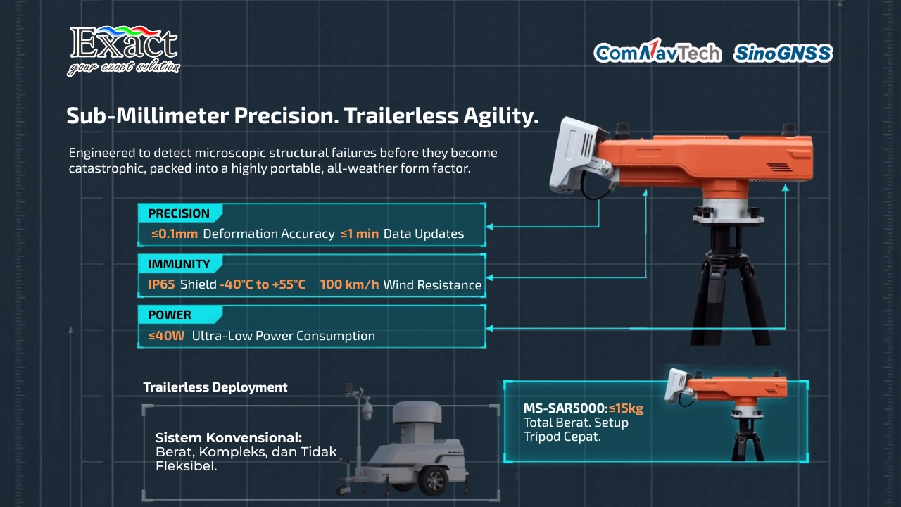
Response time and millimeter-level ground reading accuracy are the lifelines for our team in the field. The MS-SAR5000 radar is designed with Spatial and Temporal Resolution capable of recording microscopic vibrations.
For the spatial resolution aspect, the deformation movement measurement accuracy provided by this system breaks through figures below 0.1 millimeters (≤0.1mm). This detailed capability is further strengthened by a range resolution limit of ≤0.2 meters and an angular resolution measurement that is very thin at the ≤5mrad level. Meanwhile, from the temporal resolution side, our device’s data update transmission speed runs constantly at less than once every minute (≤1 time/min). This super-fast sub-millimeter data exchange allows us to check slope stability that very second to respond to dangers caused by sudden weather changes or strong vibrations from heavy equipment maneuvers.
Differential Interferometry (D-InSAR) Sharpness
How does the radar detect hair-sized displacements from a distance of 5 kilometers? This analytical technology is often referred to in the radar industry as Differential Interferometry (D-InSAR) (information outside the source).
The basic working mechanism of our MS-SAR5000 instrument relies on the emission of high-speed electromagnetic wave projections shot evenly towards the target slope. The system then captures the bouncing waves to assemble a high-resolution visual. Armed with scanning routines that repeat endlessly, the device will acquire several layers of image captures at once to be compared later. It is the mathematical differential analysis calculated from the gaps between these sequential images that intelligently detects every volume of our ground displacement.
Trailerless Deployment
The mobility of moving excavation locations demands equally compact equipment. Giant-scale conventional radars always need heavy trailer vehicles to be mobilized. The MS-SAR5000 system introduces a Trailerless Deployment relocation style (information outside the source) that breaks physical boundaries.
All main components of our MS-SAR5000 units are designed to be highly portable with physical dimensions of no more than 800mm x 200mm x 280mm. The total aggregate weight, which includes the core transmitter unit, turntable mount, and data computing module, is kept at just ≤15 kilograms. This portable weight, which still maintains an anti-shock enclosure, presents various deployment modes in the field, where the team can set it to a fixed (stationary) mode or install it in a detachable configuration according to the movement of the mining line. Specifically for those of us who still want a wheeled placement format, the manufacturer provides the MS-SAR5000 solution as a complete trailer-type integration radar.
Tough Against Signal Decorrelation
Signal Decorrelation (information outside the source) caused by dust particles, fog, and rainstorms is the main factor that often messes up the scanning results of old radars. The MS-SAR5000 radar instrument is designed to have an extreme level of adaptive immunity.
The machine body enclosure is coated with an IP65 standard dust resistance and water shield. The radar can continue scanning cliff movements 24 hours a day continuously even when struck by extreme cold conditions at the limit of -40℃ up to boiling temperatures of +55℃. This capability is further reinforced by a barrier that crushes field wind speeds up to 100 kilometers per hour. This all-weather non-contact characteristic ensures our data collection is completely uninterrupted by turbulence obstacles or pollution particles amidst the uproar of extraction operations.
3D GIS Management Platform with Warning Area Masking
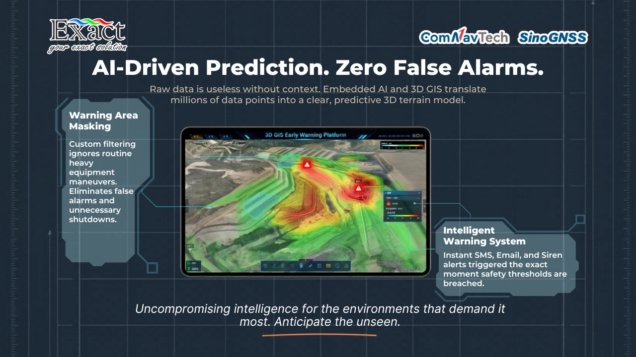
Displaying thousands of data streams in an easily digestible map layout is the main innovation behind the smart management platform of the MS-SAR5000 instrument. Our software ecosystem combines the sophistication of the Internet of Things (IoT), Artificial Intelligence (AI) models, and a 3D GIS geospatial engine framework to monitor deformation analysis results in three-dimensional visuals.
Our operators can import external three-dimensional geographic contour data using just a single touch (one-click import). Not only displaying graphics, this advanced radar is also able to embrace various inputs from other external ground measuring monitoring sensors scattered across the mining site. To guarantee there is no panic caused by false alarm sounds detecting mining bulldozer movements, the radar platform embeds a warning area masking capability. This facility freely gives us control so that the automatic alarm only evaluates purely vulnerable wall slopes thanks to its geological analytical model.
Preventive Action with Intelligent Warning System
The key to avoiding massive losses lies in the early warning gap. If the integration of data and the radar system’s analytical model concludes there is abnormal ground movement crossing our safe limit standards, the Intelligent Warning System mechanism will spark a responsive notification cycle instantly right at that moment.
The team in the field as well as the head office are immediately bombarded with sequential announcements via SMS networks and electronic mail (e-mail) instantly. The system monitor in the control center will flash indicating danger through screen indicators, sounding automatic photoelectric voice alarm signals, and can be linked as an external alarm trigger button for instantaneous activity cessation. Besides protective instruments, this device organizes operational management by presenting automatic daily reporting data, as well as weekly ranges, monthly recaps, and yearly formatted total monitoring to strengthen the decision-making maneuvers of our leadership ranks.
The device’s electrical power supply consumption is extremely small; its peak power drain limit is controlled at just the 40 Watt (≤40W) usage limit. This MS-SAR5000 platform can also absorb hybrid options of any electrical power supply available at the mine; ranging from Uninterruptible Power Supply (UPS) machines, mine central utility current towers, the operational roar of diesel generators, to stretches of solar energy circuit panels.
Dual Radar Monitoring Validation at Erdenet Mine, Mongolia
The operating structure of the MS-SAR5000 radar has been proven to overcome massive mine topographic dimensions through the validation of monitoring implementation at the Erdenet Open-Pit Mine project. This giant mine excavation arena spreads so wide touching a length dimension of around 2,300 meters and spans a width dimension of 1,500 meters.
Based on the formulation of the radar frequency curve firing behavior targeting optimal sweeping through a 120-degree rotation to reap the most meticulous cliff rock reflection sharpness effect, an opposite observation configuration format was decided. Starting in mid-May, we placed one stability radar monument each on the lip of the northern boundary territory and the lip of the southern territory, formulating full coverage on every inch of the steep cliff wall.
The surveillance testing period at the MS-SAR5000 facility clearly read that the structural stability of the south side slope plane parallel to the east direction cliff zone and the west mainland direction was in a normal and very steady status, free from projected risks of soil material deformation threats. Interestingly, the system can astutely separate active excavator movement signals. Radar observation read the pattern of cumulative displacement value monitoring at the NEW1, NEW2, NEW3, and NEW4 point parameters which were recorded to be far more dominant compared to the spread of other static points in the area, illustrating the sharpness of the MS-SAR5000 radar in helping map the location of construction operational vehicles on the mine floor.
Frequently Asked Questions (FAQ)
-
What is the absolute advantage of MS-SAR5000 technology compared to monitoring using physical prisms?
Conventional contact tools like prisms involve installation risks in avalanche-prone zones, yet the monitoring results only measure one point so they often miss reading massive mine wall movements broadly. Conversely, the MS-SAR5000 is an ArcSAR radar-based non-contact device that can be operated safely from a very long distance and is able to sweep target wall landscapes within a full 360-degree coverage up to a monitoring distance of 5 km.
-
Is the radar resolution precise enough to catch fine rock cracks before the cliff truly collapses?
Very capable. The specifications of the instrument’s internal sensors are designed to execute surface anomaly detection with tight accuracy tolerances exceeding resolution limits below the 0.1-millimeter scale (≤0.1mm), supported by a thin range resolution limit of ≤0.2m. A meticulous figure this sharp detects the vulnerability of slowly eroded materials long before the main cliff chunks free-fall.
-
How tough is the MS-SAR5000 device at repelling mining dust storms?
The MS-SAR5000 system is equipped with an IP65 stamped component shield that protects radar organs from sand intrusion as well as wet rainwater. The radar maintains firing precision in super frozen environments or extremely hot regions on fluctuation graphs of -40℃ to a peak of +55℃. The onslaught of mining wind circulation can even be offset up to a threshold speed rate of 100 kilometers per hour without interrupting data capture.
-
Can the safety alarm be falsely triggered by our heavy truck fleet maneuvering machines?
It won’t. Its software management instrument encompasses an Artificial Intelligence integration panel and 3D GIS to insert an exception setting facility, namely the warning area masking feature. This flexible function can stop the emergence of erroneous warnings such as motion detection triggered by routine construction maneuvering equipment projects.
-
What network and electricity intake options are possible if we deploy the radar remotely?
This lightweight instrument does not burden utility energy circulation because the total rotational energy of the device does not exceed the consumption load range of ≤40W. This energy flexibility accommodates hybrid supply support including UPS backup power holding boxes, site central electricity connections, solar diesel operational generators, or power supply from solar panel installations.
Full Support and Consultation Implementation
We at PT. Exact Global Teknologi are ready to guarantee your mining site’s security shield runs precisely and efficiently 24/7. Contact us to get field adjustment guidance regarding hardware specification configuration design and the installation of the MS-SAR5000 slope stability radar at the most vulnerable points within your extraction operation territory:
Exact Global Teknologi
Website : www.exactglobal.co.id
Email : marketing@exactglobal.co.id
WhatsApp : +62 812-9252-3900