When we plan, build, or renovate a structure, accurate field data is the absolute foundation of our project’s success. In today’s fast-paced construction industry, we can no longer rely on slow manual measurement methods that are prone to human error. To perfectly bridge the gap between the physical conditions on the job site and the digital models on our computer screens, we need a reliable 3D laser scanner tool for BIM (Building Information Modeling).
In this comprehensive guide, we are focusing our discussion entirely on one top-of-the-line scanning instrument specifically designed to handle heavy BIM workloads: the Topcon CR-P1. We will break down the technical specifications of the CR-P1 and explore exactly how we implement it across five major project types to produce highly accurate Point Clouds, detailed As-Built Drawings, and interactive Digital Twins with incredible efficiency.

Why Do We Choose the Topcon CR-P1 for Our BIM Workflows?
Before we dive into the specific project applications, we must understand why hardware specifications directly determine the quality of our Scan-to-BIM results. The Topcon CR-P1 is our top-of-the-line model that delivers a massive leap in point density and speed.
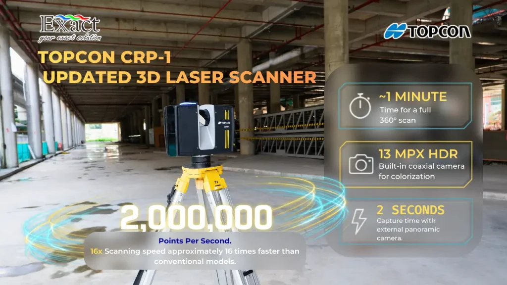
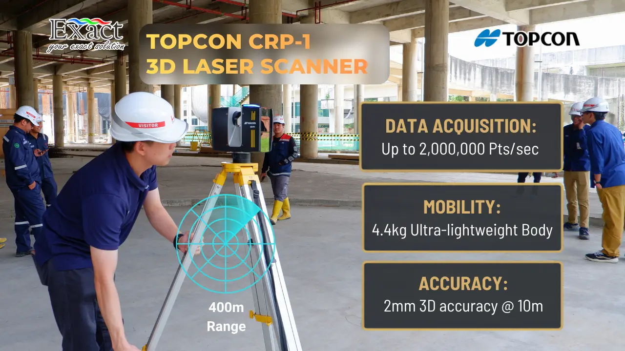
- Extreme Speed and Density: The CR-P1 is capable of recording up to 2 million points per second. This scanning speed is approximately 16 times faster than conventional models. This high speed ensures that we can collect super-dense point cloud data in just about 1 minute for a full dome scan.
- Massive Scanning Range: This device features a wide scanning range of up to 400 meters. This allows us to measure incredibly large areas in a single scan without constantly needing to move our tripod.
- High Accuracy: For precise BIM requirements, the CR-P1 provides a 3D accuracy of 2 millimeters at a 10-meter distance, and its ranging error is tightly kept to just 1 millimeter.
- Compact and Lightweight Design: Despite its high-level performance, the scanner is designed to be very compact, weighing only 4.4 kilograms (including the battery). Equipped with a quick-release mechanism, it gives us excellent mobility when we need to frequently detach it from the tripod and move through tight project environments.
- Flexible Camera Options: We can choose to use the built-in 13-Megapixel HDR camera to add true color to our point clouds, or we can mount an external panoramic camera (such as the Ricoh Theta Z1) on the scanner’s accessory bay. Using the external camera drastically cuts our image measurement time down to just 2 seconds.
- Real-Time Indicators: The system provides real-time status feedback during scanning through visual (LED lights) and auditory sounds, allowing us to monitor the device confidently even when operating it remotely.
With these powerful baseline specifications, let us look at how we apply the Topcon CR-P1 in five real-world project scenarios.
Complex Building Construction and Architecture (Scan-to-BIM)
Building or renovating high-rise towers, hospitals, or commercial facilities presents incredibly complex layout challenges. We frequently deal with overlapping mechanical, electrical, and plumbing (MEP) pipe networks.
The Project Challenge: On renovation projects, we urgently need an accurate As-Built Drawing of the building’s current condition before we can start drawing new designs. Trying to measure complex ceiling pipes manually with tape measures and laser distance meters is nearly impossible to do accurately. We need a way to capture everything exactly as it sits.
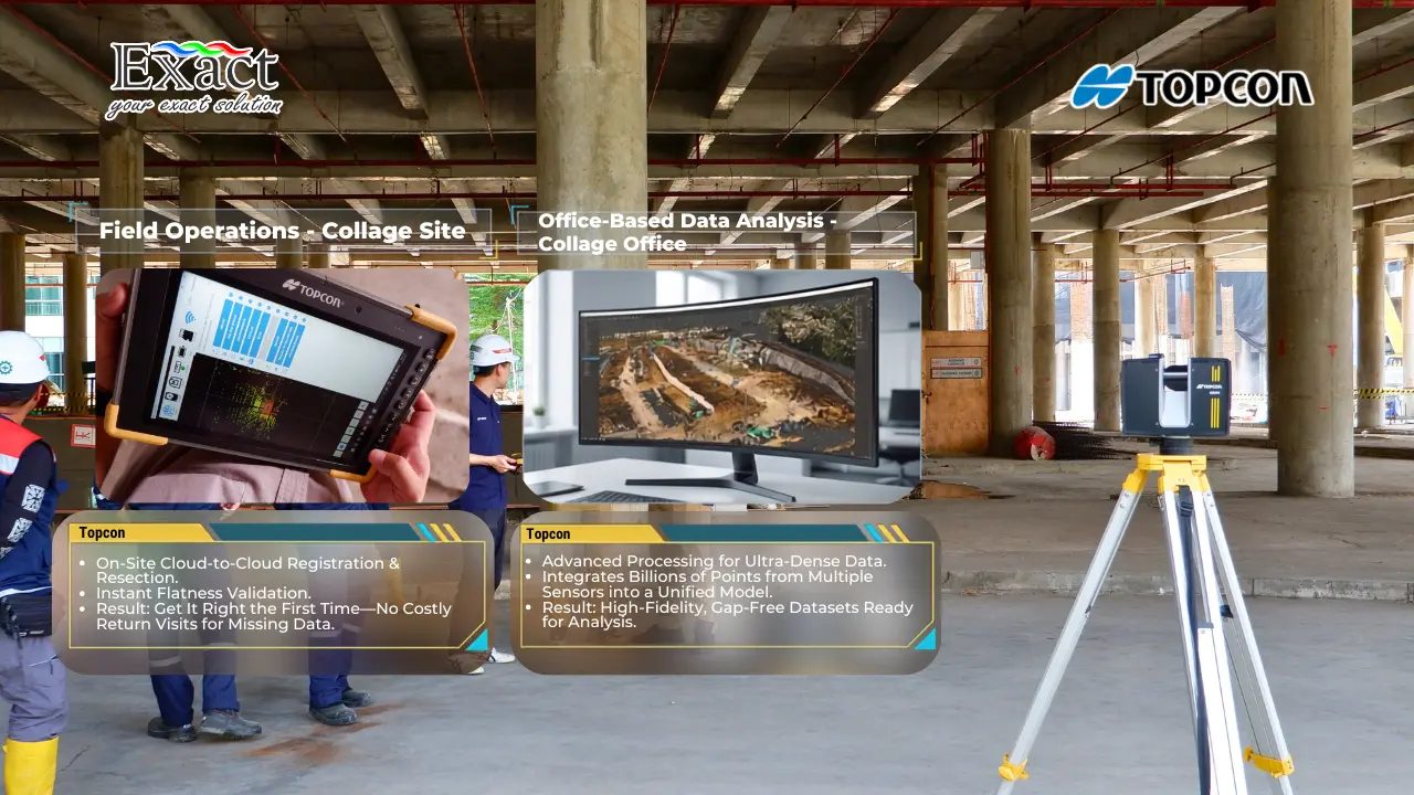
CR-P1 Implementation: We bring the CR-P1 directly into the building. Because it weighs only 4.4 kg, our surveyors can easily climb stairs and move the scanner from room to room. For indoor environments, we primarily use the Cloud to Cloud registration method. The Collage Site software automatically looks at the overlapping geometry between Room A and Room B, stitching the scans together smoothly without requiring us to set up physical targets in every hallway.
Once our dense Point Cloud is collected, we send it to our automated software, such as ClearEdge3D EdgeWise. Instead of forcing us to trace every pipe one by one on our screens, EdgeWise automatically detects the point patterns and extracts them into 3D intelligent BIM elements (like pipes or structural steel). For daily quality control, we run our scan data through Verity software, which automatically compares our new physical as-built point cloud against the original BIM design model. Verity immediately highlights any construction elements that are out of tolerance or clashing, saving us from expensive mistakes.
Earthworks and Daily Volume Calculations
Massive infrastructure projects, such as clearing land for new housing developments, require us to track earth movement every single day.
The Project Challenge: We need to know exactly how much soil volume has been excavated (cut) or filled each day to manage our project timelines and billing. Surveying dozens of acres with traditional GPS rovers takes days of walking the site. We need a method to calculate massive earthwork volumes safely and quickly.
Our CR-P1 Implementation: With a scanning range reaching up to 400 meters, we only need to set up the CR-P1 at a few strategic vantage points to scan the entire open site. We utilize the On-Site Package, connecting the CR-P1 to a high-performance tablet running the Collage Site software.
We can safely sit in our work trucks and control the CR-P1 remotely. We simply watch the visual LED indicator lights on top of the scanner to know when it is actively scanning. As soon as the scan finishes, Collage Site allows us to review the data immediately. By using the Topcon Raster Scan feature on our tablet, we can compare yesterday’s ground elevation data with today’s scan data right there on the field. The software gives us a clear heat map showing the exact cut and fill volumes, drastically cutting down our reporting time.
Factory Facility Maintenance and Digital Twin Creation
Industrial processing plants are packed with thousands of physical assets, pipes, and complex machinery. Facility owners today want to transition to modern maintenance management systems.
The Project Challenge: Our clients ask us to create a Digital Twin—an exact 3D visual and data replica of the real factory. The factory area is massive, and we are strictly forbidden from shutting down the factory machinery while we conduct our survey. We must move quickly and stay out of the way.
CR-P1 Implementation: Speed is our most valuable asset here. The CR-P1 fires 2 million points per second. To maximize our efficiency, we mount an external panoramic camera into the accessory bay on top of the CR-P1. By using this external camera, the time it takes to capture full-color 360-degree imagery drops to an astonishing 2 seconds per station.
This combination of ultra-fast scanning and lightning-fast photography allows us to document giant factory spaces in a fraction of the traditional time. We take these billions of data points back to our high-performance office computers and process them using Collage Office. This robust software handles the heavy processing load of ultra-dense point clouds effortlessly, merging data to generate highly detailed, gap-free datasets. The result is a crisp, accurate Digital Twin ready for the facility managers.
Floor Flatness and Paving Checks
Building logistics warehouses, sports facilities, or flat road pavements requires extremely strict elevation and flatness standards.
The Project Challenge: We must ensure that the newly poured concrete floor or paved surface is perfectly flat according to the BIM design. If the surface is wavy, it can cause water pooling or fail safety inspections. If we wait until the concrete cures to find a mistake, the rework costs are devastating.
CR-P1 Implementation: We bring our On-Site package directly to the freshly paved area. The CR-P1 is equipped with an automatic dual-axis compensator that ensures the scanner is perfectly leveled with an accuracy of 19 arcseconds.
Right after scanning the floor surface, our Collage Site software provides a specialized flatness check feature. It visually displays the surface elevation differences on our tablet screen as a color-coded map. This real-time analysis helps our field operators make instant decisions to fix uneven areas immediately, successfully preventing costly rework before the materials set.
Hazardous Environments and Inaccessible Infrastructure
Active landslide areas, high-voltage power lines, and towering bridge structures present extreme safety risks for our surveying teams.
The Project Challenge: We need an accurate 3D model of these structures for engineering inspections, but it is far too dangerous to send our surveyors close to the unstable cliff faces or active power lines.
CR-P1 Implementation: We leverage the Resection method built into the CR-P1. We can set up the scanner hardware in a completely safe “green zone” far away from the danger. The scanner then determines its exact coordinates by taking measurements to known control targets (prisms) placed safely at the project boundary.
Because the CR-P1 is capable of reliably scanning high-altitude targets—such as tall buildings and high-voltage power lines—from hundreds of meters away, we can digitize the entire hazardous infrastructure without ever putting our team in danger. We then safely combine these scans into one complete Point Cloud for the structural engineers to inspect from their desks.
Cloud-Based Data Management: Topcon Enterprise
When we work on large-scale BIM projects, fast data exchange between our field crews and the BIM managers in the office is critical. We manage all of the rich data collected by our CR-P1 through the Topcon Enterprise platform.
This cloud-based system gives us complete visibility of our project data via a simple web browser. All of our field scans and design datasets are visually mapped over georeferenced earth background maps. Our office team can monitor the survey progress, engage in real-time collaboration, and annotate the map directly from their computers. These instructions instantly appear on our field crew’s tablets, keeping everyone working efficiently on the latest plans. Topcon also integrates smoothly with platforms like Autodesk BIM 360 and Bentley ProjectWise, giving our designers direct access to the files without manual email transfers.
Transform Your Digital Workflows With a Trusted Partner
Adopting a 3D laser scanner tool for BIM is about much more than just buying an expensive piece of hardware. It is about adopting a complete ecosystem of automation that brings together fast field data collection, on-site registration, intelligent BIM model extraction, and strict construction verification.
By implementing the Topcon CR-P1, combined with Collage Site and advanced extraction software, we empower our teams to reduce rework costs and produce undeniable As-Built Drawings and Digital Twins.
If you want to dive deeper into how we implement the Topcon CR-P1 on projects like yours, or if you need a live demonstration of this high-speed Scan-to-BIM workflow, our team of experts is ready to provide the best solutions.
Contact Us – PT. Exact Global Teknologi We are your professional mapping, surveying, and BIM technology solution provider.
- Website: www.exactglobal.co.id
- Email Marketing: marketing@exactglobal.co.id
- WhatsApp: +62 812-9252-3900
Frequently Asked Questions (FAQ)
-
What exactly is a 3D laser scanner tool for BIM?
A 3D laser scanner is a high-speed surveying instrument that emits a rotating laser beam to measure the distance to physical objects in its environment. The result is a 3D digital representation made up of millions of dense dots called a Point Cloud. In Building Information Modeling (BIM), this exact spatial data is the required raw foundation we use to build new 3D design models or verify if the actual construction matches the blueprint.
-
Why is the Topcon CR-P1 highly recommended for BIM projects?
BIM workflows demand extreme detail. The CR-P1 is capable of shooting up to 2 million points per second. This incredible point density allows our software to automatically recognize even the smallest structural shapes (like thin pipes or architectural details), which is crucial for accurately generating 3D models and conducting quality control.
-
Can we use the CR-P1 to create As-Built Drawings for old buildings?
Absolutely. Old buildings often lack accurate blueprints. Because the CR-P1 is exceptionally lightweight (only 4.4 kg), our surveyors can carry it up stairs and easily navigate tight hallways. The resulting point cloud provides a flawless 100% accurate database to draw a highly precise As-Built Drawing representing the building’s current state.
-
How does the CR-P1 speed up the creation of industrial Digital Twins?
Creating a Digital Twin requires capturing a massive amount of geometric data and visual imagery from a facility. The CR-P1 features an accessory bay for an external panoramic camera that captures a full 360-degree image in just 2 seconds. Combined with scanning 2 million points a second, we can rapidly digitize giant factories without disrupting their daily operations.
-
Do we have to drive back to the office to check if our scan registration worked?
No. We utilize the On-Site Package workflow by running Collage Site software on a high-performance field tablet. This allows us to perform cloud-to-cloud matching and resection registrations directly on the job site. We can even view a floor flatness analysis just seconds after the CR-P1 finishes spinning, ensuring we never go home with incomplete data.
-
How far can the CR-P1 scan, and how does this help in hazardous areas?
The top-tier CR-P1 L model can scan targets up to a maximum radius of 400 meters. This extreme range allows us to perform surveys on tall bridges, landslide areas, and high-voltage lines while standing safely far away from the danger zone, all without sacrificing our 3D data accuracy.
-
What role do EdgeWise and Verity play after the CR-P1 collects the data?
Manually tracing a 3D model over millions of raw laser points takes months. Software like EdgeWise dramatically speeds this up by automatically extracting pipes and steel structures directly from the point cloud. Verity is used during construction quality control; it automatically overlaps our CR-P1’s physical as-built scan onto the planned BIM model, instantly highlighting any structures that were built out of alignment.