Managing material inventories in large-scale factories or mining areas is a highly challenging task. Every day, thousands of tons of material enter and leave, creating a fast-paced logistics dynamic. We have found that many industrial companies in Indonesia still struggle to track their material inventory accurately. Inaccuracies in recording this inventory often trigger fatal data discrepancies, causing companies to bear swelling financial losses from year to year.
To resolve these systemic issues, we implemented an innovative mapping solution based on a slam scanner lidar. By using this advanced three-dimensional scanning device, we help various companies completely overhaul how they manage and audit their inventory. Vast, dark, and thickly dusty indoor warehouses can now be mapped and their material volumes calculated precisely in just a few minutes.
Below is a comprehensive breakdown of our field case study at one of the largest aggregate supplier facilities in Indonesia, and how the application of this technology brings real transformation to storage management.
The Dilemma of Volume Audits in Indoor Warehouses
We conducted this field mapping at a major national supplier facility for cement, crushed stone, and aggregate materials in West Java. This facility supplies the needs of crucial infrastructure projects across various regions in Indonesia.
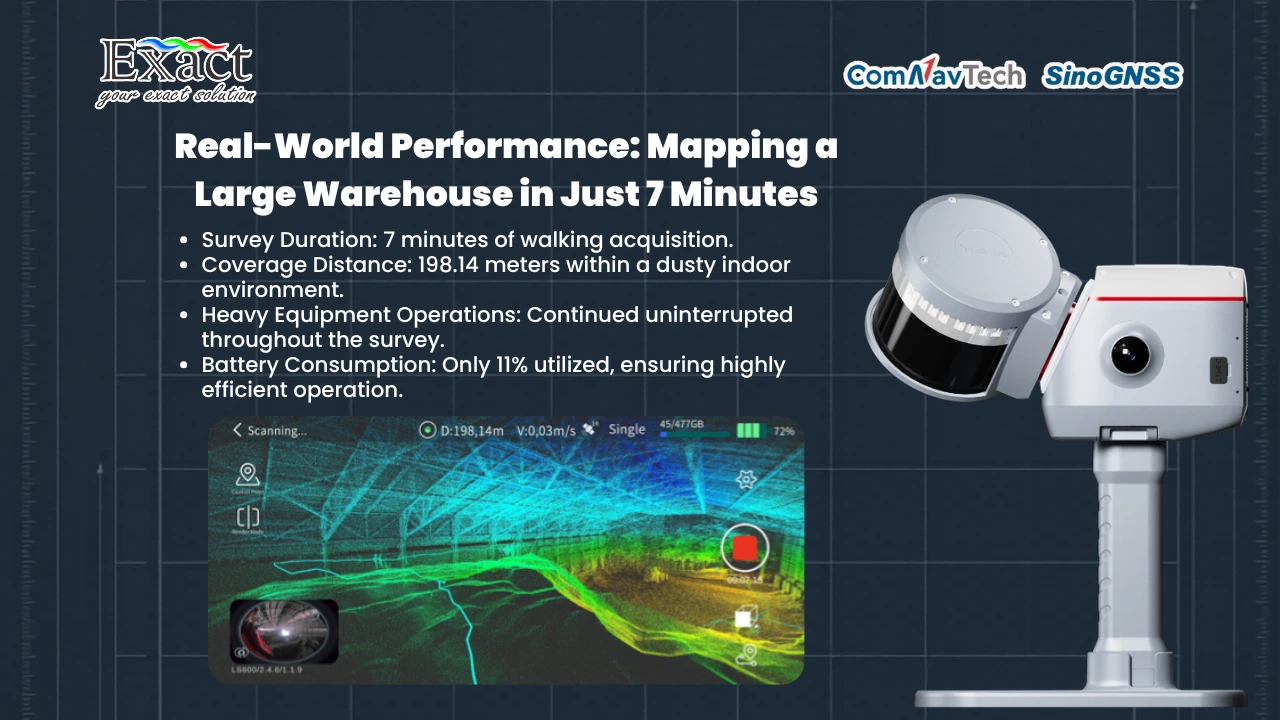
The operational challenges we faced in the field were highly complex. Our team had to map the raw material stockpile located inside a giant enclosed building (indoor). The conditions inside the warehouse were very dusty with minimal lighting. The biggest hurdle was that we were absolutely not allowed to stop the operations of the heavy equipment (loaders) that were busy moving materials inside the warehouse area.
Previously, the facility’s management still relied on older approaches. The audit dilemma began because the conventional raw material volume survey method has many fundamental weaknesses. The surveyor team needed days to map a vast area using traditional land measuring tools. Besides wasting productive time, this old method also produced estimated data that was highly vulnerable to inventory calculation discrepancies.
The company had actually tried using an older type of SLAM (Simultaneous Localization and Mapping) instrument. However, that older version had a separated camera sensor (split type) and was not directly integrated with a GNSS satellite signal receiver antenna. This made the tool unstable when used by a surveyor while walking and prone to data synchronization disruptions. From this, the urgency became clear: the company needed a robust digital system to map enclosed spaces quickly, provide accurate data, and avoid disrupting the working heavy equipment entirely.
Storage Management Digitalization with SLAM LiDAR
To break through the limitations of the old methods, we brought the latest scanning technology solution. We realized this digital transformation of storage management using the all-in-one handheld 3d laser scanner instrument, the ComNav SinoGNSS LS600 series. This portable three-dimensional scanner is specifically designed to map spaces in extreme environmental conditions with limitless mobility.
The design of this handheld device highly supports our team’s maneuvering speed. The weight of this tool is very light, at only 1.9 kilograms (which already includes the battery and calibration plate). We simply turned on the device and walked along every side of the material pile inside the warehouse. The built-in smart application called Scan Master (Android-based) allowed us to monitor the recording of the point cloud and our walking route in real-time. All of our mapping data was securely saved into a massive 512GB built-in SSD memory.
The proof of this technology’s capabilities is concretely recorded in our mapping data at the facility:
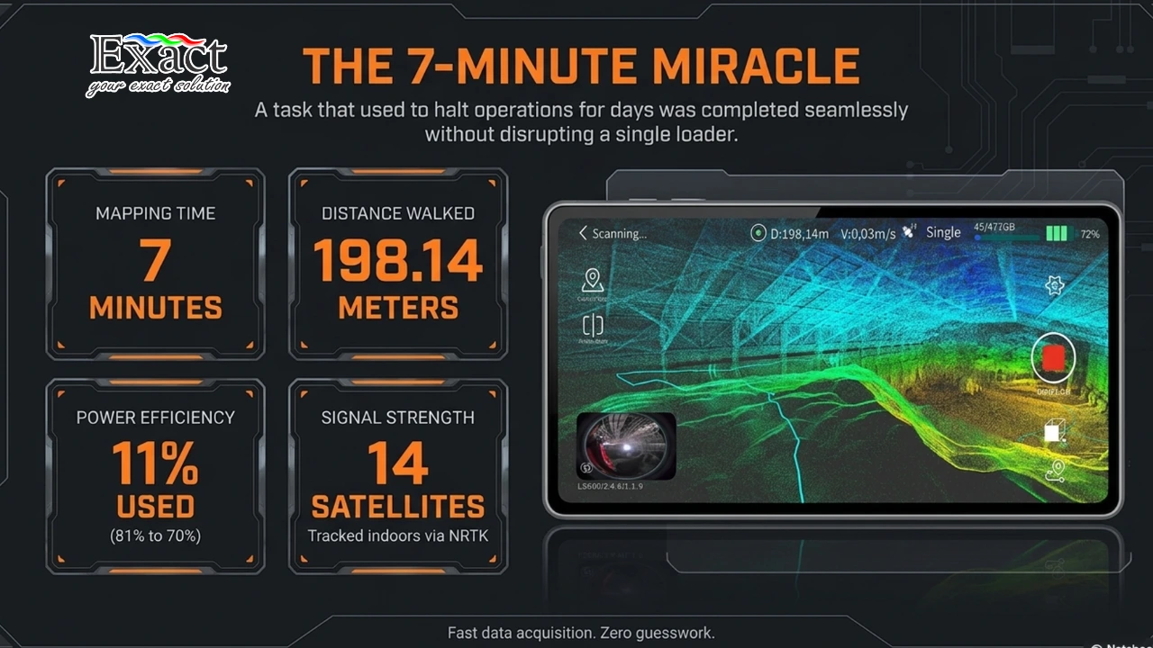
- Total Trajectory Distance: We walked a distance of 198.14 meters covering the warehouse area.
- Mapping Time: We successfully scanned the entire giant stockpile area in a very short time, which was just 7 minutes.
- Satellite Tracking: Even in a challenging indoor environment, our antenna system still managed to track 14 satellites using the NRTK positioning method for high accuracy.
- Battery Efficiency: This instrument is highly power-efficient. We started the job with an 81% battery capacity and finished with 70% power remaining. The internal Li-ion battery (49.34Wh) can last up to 1.5 hours of continuous use in total.
Why Do Integrated Handheld Systems Excel?
Many other brands in the industrial market still maintain a separated scanner system (Split Type), where the GNSS module, camera sensor, and battery are connected using a network of cables. These cables greatly restrict the operator’s movement space, are prone to getting snagged in narrow terrains, and risk creating data transmission delays between sensors.
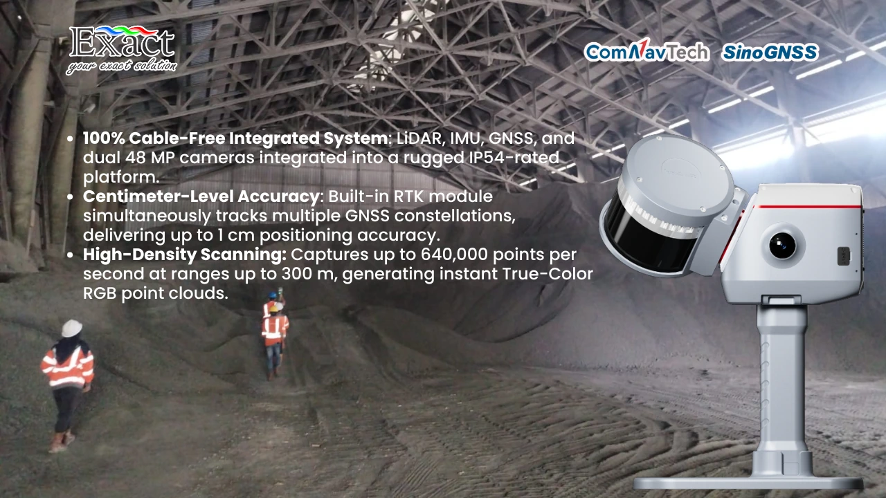
Conversely, the SinoGNSS LS600 instrument we operate is purely an integrated device gnss slam imu. This means all crucial sensors like the Laser scanner (LiDAR), motion sensor (Inertial Measurement Unit / IMU), Global Navigation Satellite System (GNSS) receiver antenna, and Camera have been fully embedded into a single compact body. The body is also molded from impact-resistant aluminum with industrial-grade IP54 protection certification.
The advantages of this integrated system are extraordinary when we break down the technical specifications:
- Centimeter-Level Accuracy: We no longer need to deal with assembling external antennas. The built-in RTK module embedded inside our device can capture multi-constellation satellites simultaneously (GPS, BDS, GLONASS, Galileo), resulting in a processed relative accuracy of 1 centimeter.
- Extreme Data Point Density: This device offers 16-line or 32-line laser sensor configurations. At maximum configuration, the tool’s sensor can emit and capture up to 640,000 spatial points every second with a maximum reflection range reaching 300 meters.
- True Colorization (Visual-SLAM): The device is equipped with two 48-Megapixel wide-angle cameras with a 190° x 190° field of view. These smart cameras provide actual colors (RGB True Color) directly to the point cloud model the moment after we finish scanning (Direct Output After Scan).
Three-Step Workflow: Data Extraction to Visualization
We provide a clean workflow architecture to guarantee that raw data can be turned into inventory reports ready for execution by the company. We divide this process into three operational stages:
Stage 1: Field Data Acquisition. We use the Scan Master mobile application to initiate recording. After the tool detects the proper calibration between GNSS, IMU, and LiDAR, we begin walking to scan the piles. Topography and motion trajectory data are automatically stored inside the device.
Stage 2: Processing. After the field survey is complete, we transfer the raw data to an office computer via a USB connection (U-Disk Mode) or Wi-Fi. We then use advanced analytical software such as RealEditor and LiDAR360 MLS. This software is responsible for aligning sensor positions and cleaning data from disturbances (noise filtering), such as removing dust shadows or heavy equipment unintentionally recorded while maneuvering.
Stage 3: Output & Analysis. The software forms a complete and dense three-dimensional model. From this 3D map, we extract the calculation values of the volume and area of the material piles. We can then export this report into various industry-standard formats like LAS, PLY, E57, or DXF so it can be directly integrated with GIS or CAD software owned by the planning staff at the client’s company.
ROI (Return on Investment) of Storage Transformation
The deciding factor most awaited by the board of directors and financial managers is data-based analytical proof. From the results of point cloud processing at the aggregate factory facility, we proved that the storage audit transformation using LiDAR technology provides a very fast and profitable Return on Investment (ROI).
Through the software system, we obtained a highly precise calculation result that the total volume of aggregate material inside the warehouse is 6,897.477 cubic meters, covering a floor surface area of 1,510.875 square meters.
The absolute advantage that provides the biggest investment value from this technology is our software’s ability to track the dynamics of material inventory historically (Cut and Fill analysis). The software compares the previous survey with the current survey, matching material cells with an accuracy rate of 95%. From this high-level analysis result, the system provides details of material mutation: the addition of new material volume (Added volume) amounting to (+) 6,897.615 cubic meters, and the reduction of material taken by heavy equipment (Removed volume) amounting to (-) 0.138 cubic meters.
This level of data transparency reaching decimal counts is highly essential for the accounting team and logistics managers. The activity of recording material movement coming in and out now no longer requires manual guessing. All forms of inventory discrepancies or material loss risks become transparent. The survey execution time that used to hinder operations for days is now finished in just 7 minutes. This directly reduces operational expenditure (OPEX) costs, saves the company from asset losses, and revolutionizes the speed of inventory report generation to be instantaneous.
Frequently Asked Questions (FAQ)
Is this handheld scanner durable for use in highly dusty mining areas or facilities?
Very durable. The body of the LS600 device is designed using industrial-standard aluminum material with IP54 protection certification. This tool is highly immune to the infiltration of thick dust particles from heavy equipment activities, resistant to water splashes, and can function reliably in environmental temperature ranges from freezing -20°C conditions to hot +50°C temperatures.
How long can this LiDAR scanner operate without needing to recharge the battery?
Our tool is powered by an internal Li-ion battery with a capacity of 49.34Wh (14.4 V). In a fully charged condition, this battery can supply power for up to 1.5 hours of continuous use in the field. Considering that mapping a 198-meter wide area only takes 7 minutes and uses about 11% power, the capacity of one battery is more than enough to handle various stockpile mapping tasks in a single daily operation cycle.
What digital report formats can be exported, and are they easy to read by the company’s computer system?
The system directly generates raw point cloud data in the actual .las format. Through our built-in processing software, this data can be easily exported again into LAZ, PLY, E57, and DXF formats. All of these data structures are guaranteed to be fully compatible to be imported into GIS software or CAD design systems already existing in your company’s facility.
Why is the Integrated Device system more recommended than the Split Type SLAM?
Older Split-type SLAM tools use a cable network to bind various components like GNSS antennas, batteries, and optical camera sensors. These dangling cables severely restrict the physical mobility of the operator and are prone to triggering delay synchronization problems between sensors. Our LS600 instrument unites all these important sensors inside one solid body without external cables, making it far more practical, stable, compact, and ensuring data fusion (LiDAR, GNSS, IMU) runs perfectly.
Can this technology specifically distinguish which materials are newly poured and which have been excavated by machines?
Absolutely. Our analytical software has the capability of 3D surface profile comparison (Surface-to-Surface Comparison). The system will automatically cut material elevation contours and provide a history report of Added Volume (newly entered material) as well as Removed Volume (material that has been taken) complete with highly detailed cubic decimal figures for your audit recapitulation needs.
System Procurement and Consulting Information
Raise the standard of your storage space management accuracy and secure your company’s financial balance sheet with us. Stop relying on conventional manual survey methods that waste time, are expensive, and are vulnerable to manipulation or data errors.
To schedule an exclusive tool demonstration session at your operational location, ask about inventory management software integration, or consult regarding the procurement of industrial-grade 3D Lidar instruments, please contact our technical team:
Website : www.exactglobal.co.id
Email : marketing@exactglobal.co.id
WhatsApp : +62 812-9252-3900


