Solusi Survey Vegetasi dengan ComNav LS600

Buat yang pernah turun ke lapangan buat survei vegetasi, pasti tahu rasanya: panas, keringetan, dan ribet banget ngukur pohon satu per satu pakai pita ukur.
Apalagi kalau areanya luas, ratusan bahkan ribuan pohon bisa makan waktu berhari-hari. Sekarang bayangin kalau semua itu bisa dilakukan hanya dengan satu alat, dalam hitungan menit. That’s where ComNav LS600 hadir—handheld 3D laser scanner yang lagi jadi bintang baru di dunia survei digital.

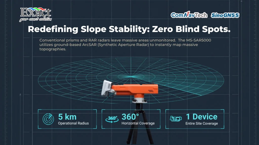
Kenapa Data Vegetasi Itu Penting?

Buat perusahaan perkebunan dan kehutanan, data pohon bukan sekadar angka. Dari diameter (DBH), keliling batang, sampai tinggi pohon—semua jadi dasar
perhitungan potensi panen, biomassa, hingga cadangan karbon. Masalahnya, metode konvensional masih manual:

  • Butuh banyak orang.
  • Prosesnya lama.
  • Data sering tidak konsisten.

Apalagi di bawah kanopi rapat atau area sinyal GPS lemah, alat digital biasa bisa langsung “nge-lag”. Di sinilah teknologi SLAM jadi solusi cerdas.


Apa Itu Teknologi SLAM (Simultaneous Localization and Mapping)?

SLAM memungkinkan pemindai “jalan sambil memetakan” area sekitarnya secara real-time tanpa bergantung sinyal satelit.
Dengan kombinasi sensor LiDAR, kamera, dan IMU, alat menangkap bentuk objek dan membentuk peta 3D otomatis.
Artinya, survei tetap presisi di hutan rapat, lembah, atau area tertutup.
Teknologi ini lama dipakai di robotika dan mobil otonom, dan kini diadaptasi untuk survei geospasial dan perkebunan.


LS600: SLAM 3D Scanner yang Siap Turun ke Lapangan

ComNav LS600 adalah pemindai laser 3D portabel yang dirancang untuk kondisi lapangan nyata—dari area terbuka hingga hutan lebat.
Fitur unggulannya:

  • SLAM Algorithm — tetap akurat meski tanpa GPS.
  • LiDAR 32-line — hingga 640.000 titik/detik.
  • Dual Camera 48MP — point cloud berwarna realistis.
  • Built-in RTK Module — akurasi posisi absolut hingga 3 cm.
  • 512 GB Storage & Battery Hot-Swap — siap kerja seharian.

Bobot hanya ±1,9 kg—mudah dibawa jalan kaki di kebun, hutan, atau site proyek.


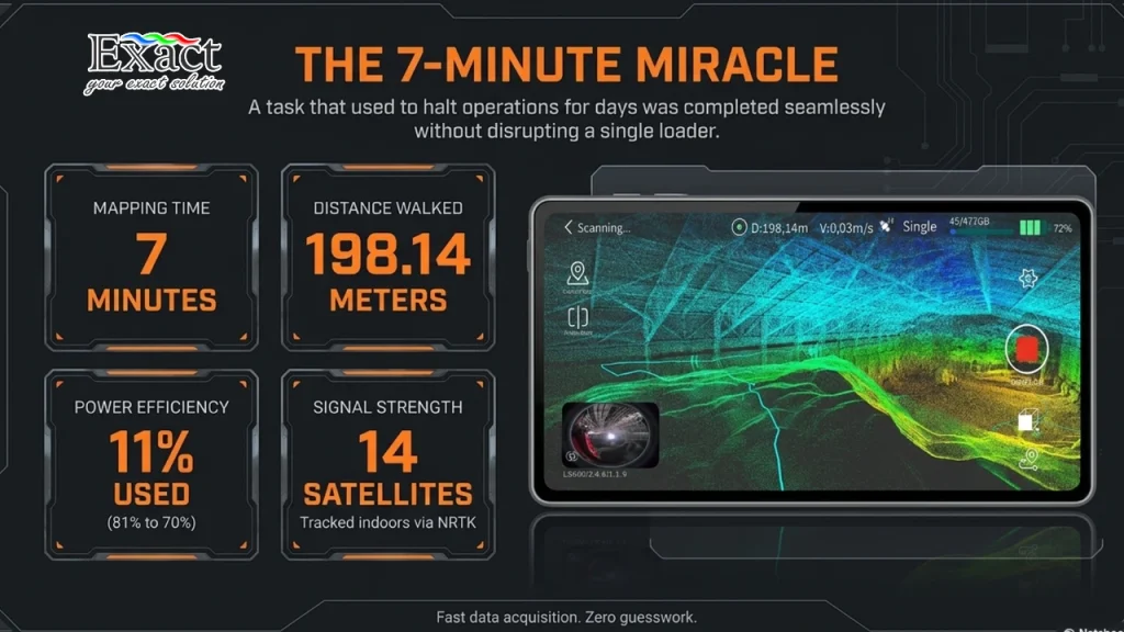
Uji Coba Lapangan: Dari Manual ke Digital

Proses survey vegetasi manual dengan mengukur lingkar pohon
Pengukuran DBH (Diameter at Breast Height) pohon, salah satu metode survey vegetasi manual yang memakan waktu.

Tim teknik Exact Global Teknologi menguji LS600 di Bumi Perkemahan Cibubur, Bogor—area vegetasi rapat yang ideal untuk tes “real”.
Dua metode dibandingkan:

  1. Pengukuran manual pakai pita ukur (DBH).
  2. Scanning digital pakai LS600.

Operator cukup berjalan memutar pohon sambil membawa LS600. Dalam menit, point cloud 3D area langsung terbentuk. Hasilnya:

  • Akurasi LS600 selisih hanya 1–3 cm vs manual.
  • Hemat waktu > 50%.
  • Data siap olah di ScanMaster & RealEditor menjadi model 3D.

Data Lebih Kaya, Analisis Lebih Dalam

Perbandingan hasil scan 3D survey vegetasi menggunakan LiDAR 360 MLS
Perbandingan visual antara foto asli (atas) dan hasil rekonstruksi 3D dari proses survey vegetasi menggunakan LiDAR (bawah).
Dari model 3D, Anda bisa:

  • Mengukur diameter dan keliling batang.
  • Menganalisis struktur vegetasi: kanopi, cabang, batang.
  • Mengestimasi volume dan biomassa pohon.
  • Melihat distribusi pohon dalam satu blok kebun.

Data dapat diintegrasikan ke GIS dan sistem manajemen perkebunan untuk pelaporan cepat.


Mengapa SLAM LS600 Cocok untuk Perkebunan?

  • Cepat — survei ratusan pohon dalam hitungan jam.
  • Akurat — centimeter-level meski tanpa GPS.
  • Efisien — mengurangi kebutuhan tenaga kerja.
  • Adaptif — cocok untuk hutan, perkebunan, hingga konservasi.

Contohnya, di industri perkebunan sawit dan karet, LS600 bisa bantu pendataan jumlah dan kondisi tanaman produktif dengan jauh lebih cepat. Sementara di sektor kehutanan, alat ini ideal buat perhitungan volume, biomassa, dan inventarisasi pohon berdiri tanpa harus menebang

Area survey vegetasi dengan pohon yang ditandai untuk pengukuran
Sebuah pohon di lokasi penelitian ditandai sebagai bagian dari proses survey vegetasi.

Area survey vegetasi dengan pohon yang ditandai untuk pengukuran

Uji coba di Cibubur membuktikan satu hal: ComNav SLAM LS600 bukan sekadar teori—melainkan solusi efisien dan akurat. Dengan satu alat kecil, Anda mendapat data lebih cepat, lebih presisi, dan sepenuhnya digital. Jika dulu survei vegetasi identik dengan kerja berat dan lama, sekarang cukup scan lalu data siap dianalisis.

Share this post:

The Ultimate Guide to Ground Penetrating Radar Frequency: Why the Flexible 30MHz Antenna is the Best Solution for Deep Penetration in Extreme Terrains

The Ultimate Guide to Ground Penetrating Radar Frequency: Why the Flexible 30MHz Antenna is the Best Solution for Deep Penetration in Extreme Terrains

The MALÅ Rough Terrain Antenna (RTA) 30MHz is a specialized Ground Penetrating Radar (GPR) solution engineered for deep subsurface investigations in challenging environments like thick forests and rocky mountains. Featuring a unique “snake-like” flexible design, this unshielded antenna can be maneuvered easily through dense vegetation and uneven terrain without the need for time-consuming land clearing. Its low-frequency 30MHz signal offers maximum depth penetration, making it highly effective for depth-to-bedrock mapping, glaciology, and deep groundwater resource identification. When integrated with the MALÅ ProEx Control Unit, the system supports multi-channel data collection, allowing users to reduce project timelines and manpower requirements by up to two-thirds compared to traditional antennas.

Tips for Choosing a Professional Geoelectrical Service: Why ABEM Terrameter LS 2 is the No. 1 Choice in Indonesia

Tips for Choosing a Professional Geoelectrical Service: Why ABEM Terrameter LS 2 is the No. 1 Choice in Indonesia

Selecting a professional geoelectrical service is critical for the success of major projects, requiring uncompromised data accuracy and high-resolution results for tasks such as groundwater prospecting and mineral exploration. This guide highlights the ABEM Terrameter LS 2 as the premier choice in Indonesia, featuring isolated measurement channels with dedicated 24-bit digitizers to prevent signal interference. Key advantages include revolutionary 100% Duty Cycle IP for faster, high-quality data collection and a rugged IP66-rated aluminum casing built to withstand harsh tropical environments. Additionally, its smart technology enables remote monitoring via VNC and instant troubleshooting over a VPN, significantly minimizing project downtime. Backed by PT. Exact Global Teknologi, the official distributor in Indonesia, the system ensures versatile applications across various sectors and exceptional after-sales support.

Accelerating Nickel Laterite RKAB 2026: Why “Walking TEM” is the Key to Efficiency in Indonesia’s Extreme Terrain

Accelerating Nickel Laterite RKAB 2026: Why “Walking TEM” is the Key to Efficiency in Indonesia’s Extreme Terrain

The ABEM GroundTEM Trek is a revolutionary “Walking TEM” solution designed to help mining companies in Indonesia meet the urgent RKAB 2026 deadlines and strict MinerbaOne reporting requirements. By replacing slow, traditional cable-based methods with a lightweight, backpack-mounted system, this technology enables 10x faster mapping of the subsurface in real time.Key highlights of the system include:Superior Portability: The system is entirely cable-free and worn on the backs of two operators, with the receiver backpack weighing 10 kg and the transmitter backpack weighing 15 kg.Optimized for Nickel Laterite: It accurately maps the complex electrical contrasts between resistive caprock and conductive limonite and saprolite zones at depths of 50 to 100 meters.Real-Time Visualization: Using an Android mobile app, operators can view live pseudo-2D color sections and 1D inversions directly in the field, allowing for immediate geological insights.Rugged Design: Built for extreme Indonesian terrain, the hardware is IP67-rated, making it completely resistant to dust and heavy tropical rain.Operational Precision: A built-in “Coil Distance Regulator” ensures data quality by monitoring the 15-meter operator spacing in real time via visual and audible alerts.Continuous Mapping: The system’s dual-moment transmitter and high-density logging allow crews to map hectares of land daily, eliminating zero-value setup time.This advanced geophysical tool, distributed by PT. Exact Global Teknologi, is the ultimate strategy for accelerating exploration and securing mining permits in Indonesia’s demanding environments

Translate »