The mining landscape in Indonesia is undergoing a massive shift. The Ministry of Energy and Mineral Resources (ESDM) is strictly enforcing new reporting rules, requiring mining companies to submit their work plans and budgets (RKAB) through a centralized digital system called MinerbaOne. For us operating in the field, this means we must update our Feasibility Studies (FS) and environmental documents faster and more accurately than ever before. To meet these tight deadlines without stopping our operations, we are completely changing how we map the earth.
We are adopting the Transient Electromagnetic Method for Nikel Laterit Exploration 2026. Instead of laying out heavy, slow cables across dense jungles, we are using a “Walking TEM” system: the ABEM GroundTEM Trek. This backpack-mounted technology lets our teams walk over the terrain and see the subsurface in real time.
Here is exactly how this equipment works, how we use it in the field, and why it is our primary strategy for accelerating exploration and securing our mining permits.
The Urgency of Fast-Tracking RKAB Tambang
Right now, the government is moving away from the three-year RKAB approval cycle and returning to a one-year approval cycle for 2026. This policy is designed to help the government control commodity supplies, balance market demand, and protect the nation’s energy and mineral reserves for future generations.
For our mining operations, this creates immediate pressure. We must submit our RKAB 2026 documents via the MinerbaOne application before the end of the year. If we experience delays in getting our RKAB approved, our entire mining operation could be forced to stop. A shutdown damages our financial stability and halts our environmental reclamation efforts.
Currently, about 50% of mining companies have begun updating their Feasibility Studies in the new system. To ensure we are not left behind, we need geological data instantly. Fast-Tracking RKAB Tambang requires us to abandon slow traditional surveys. We need a rapid, mobile solution that feeds high-quality data directly into our geological models.
The Science of the Transient Electromagnetic Method
Ilustrasi cara kerja ABEM GroundTEM Trek
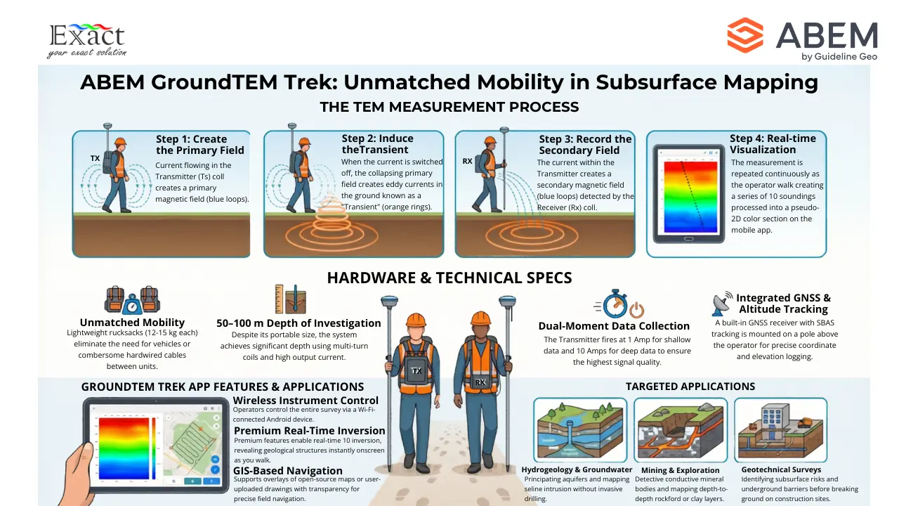
To map the ground quickly, we rely on the Transient Electromagnetic (TEM) method. This method works by creating and measuring magnetic fields to determine the electrical conductivity of the earth beneath our feet.
Our transmitter backpack sends a direct electrical current through a transmitter coil, which creates a static primary magnetic field. We then shut this current off extremely fast. This abrupt shut-off induces an electrical field in the surrounding ground.
When this electrical field enters the earth, it generates electrical currents known as “eddy currents”. These eddy currents then create their own secondary magnetic field. Because the ground has natural electrical resistance, these currents gradually lose energy and turn into heat. As the currents weaken, they move deeper and wider into the earth.
The receiver coil, worn on a second backpack, measures this decaying secondary magnetic field over time. Right after the transmitter turns off, the signal gives us data about the shallow soil layers. Microseconds later, as the eddy currents travel deeper, the signal tells us about the deeper rock layers. By constantly repeating this process while we walk, we build a continuous map of the ground’s conductivity at different depths.
Identifying Nickel Laterite Zones
Indonesia’s nickel laterite deposits are formed by the deep, long-term weathering of ultramafic rocks. A typical laterite profile consists of a top layer of caprock, a middle layer of limonite, a lower layer of saprolite, and finally the unweathered saprock or bedrock at the bottom. The economic nickel resources are found within the limonite and saprolite zones.
Mapping these specific zones is difficult because the boundary between the limonite and saprolite is highly irregular and complex. Drilling holes every 40 meters is simply not enough to map this uneven boundary accurately. This is where the TEM method excels.
The different layers in a laterite profile contain different amounts of clay. Clays, especially types like smectite, hold moisture and have a high cation exchange capacity (CEC), making them highly conductive to electricity. Caprock, on the other hand, is usually dry and contains kaolinite clay, which has a very low CEC, making it highly resistive to electricity. By using the ABEM GroundTEM Trek, we map these distinct electrical contrasts, allowing us to accurately locate the conductive limonite and saprolite zones hidden beneath the resistive caprock.
Overcoming Extreme Terrain with Backpack Hardware
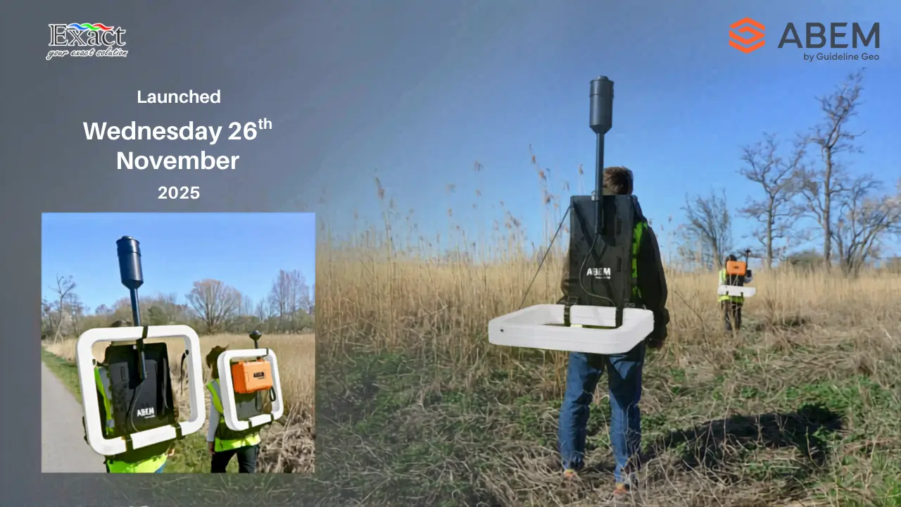
In the past, running a TEM survey meant our field crews spent hours clearing jungle paths to lay out massive, heavy wire loops on the ground. The ABEM GroundTEM Trek eliminates all ground cables. The entire system is worn on the backs of two operators.
The system is transported to our sites in two rugged cases. We have a 32 kg hard case that holds the electronic instruments and batteries, and a 10 kg soft case that holds the transmitter and receiver coils.
When we assemble the equipment in the field, the total weight of the receiver backpack is only 10 kg, and the transmitter backpack weighs 15 kg. Because we explore in tropical, demanding environments, the equipment is built to survive. The coils, transmitter unit, and receiver unit are all made of high-impact ABS plastic and carry an IP67 rating. This means the hardware is completely protected against dust and can easily handle the heavy rain we frequently encounter in the Indonesian wilderness.
Perfecting Accuracy with A 10-Meter Coil Separation
To gather clean, usable data, we must operate the system correctly. We divide our field crew into pairs. One person wears the transmitter (Tx) backpack, and the other wears the receiver (Rx) backpack.
The system is built around a 0.65 m x 0.65 m transmitter coil and a 0.65 m x 0.65 m receiver coil. While the instrument’s software is optimized for a nominal a 10-meter coil separation, our operators typically maintain a visual distance of about 15 meters while walking.
Maintaining the correct distance is incredibly important. If our two operators walk closer than 5 to 6 meters to each other, the receiver measurement gate becomes saturated, and the system will record incorrect polarity data. To prevent this, we control the survey using the GroundTEM Trek App on an Android mobile device.
The app features a visual “Coil Distance Regulator” right on the main screen. As we walk, this color-coded bar monitors the exact space between the two backpacks. If the operators drift too far apart or walk too close together, the bar turns red, the Android device vibrates, and the receiver backpack emits a loud beep to warn the crew. We simply stop, adjust our spacing until the bar turns green, and continue our survey.
Fast Data Logging and a 15-Second Sounding Duration
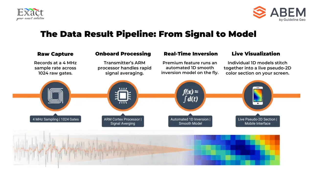
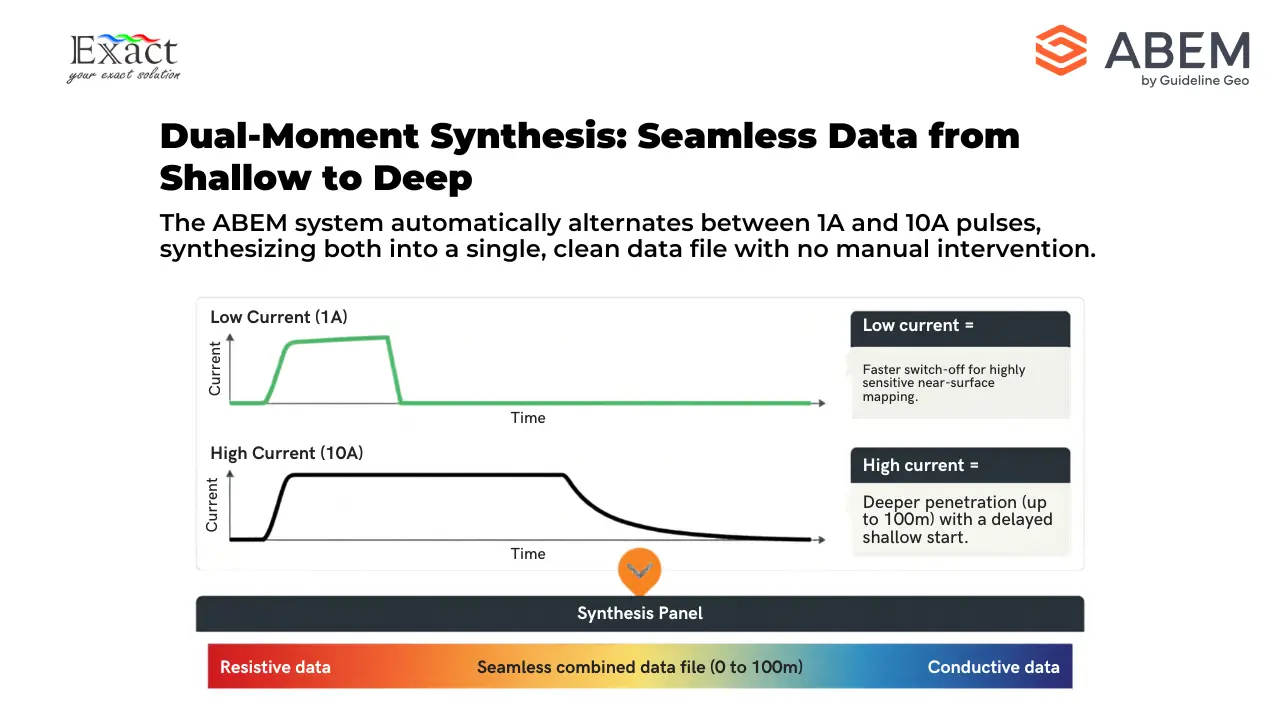
We are accelerating our exploration timelines because we collect data continuously without stopping. The system’s dual-moment transmitter is powerful. It fires a 1 Amp current for reading shallow ground data and a 10 Amp current for reading deeper data.
The receiver platform captures these returning magnetic signals at a massive 4 MHz sample rate with a dynamic range greater than 24 bits. The system logs up to 1024 raw data gates directly to its 128 GB internal solid-state drive.
Because the transmitter pulses so rapidly while we walk, the dense cluster of data points we gather over a small area effectively gives us the equivalent of a 15-second sounding duration for every localized spot we pass over. This high-density, continuous logging allows us to map hectares of land in a single day, delivering the fast results we need for our RKAB submissions.
Instant Insights Through Real-Time Subsurface Profiling
Perhaps the greatest advantage of the ABEM GroundTEM Trek is that we no longer have to wait days to process data in the office. If our instrument has the Premium features enabled, we use the real-time inversion tab built directly into the mobile app.
As we walk through the jungle collecting data, the transmitter’s onboard ARM processor automatically runs a preliminary 1D inversion using a smooth mathematical model. The app then connects these individual 1D models along our walking path.
When we look at our Android screen, we see a live, pseudo-2D color section of the earth beneath us. We can instantly see the depth of investigation (DOI) and watch the resistive caprock and the conductive nickel laterite layers form on our screen as we walk. If we encounter an interesting ore body, we know about it immediately in the field.
Applied for Mineral, Groundwater, and Geotechnical Exploration
While we focus heavily on mapping shallow nickel laterite deposits, this equipment is a multi-purpose tool. The system gives us a highly reliable depth penetration range of 50 to 100 meters.
Because of this specific depth range, the ABEM GroundTEM Trek is officially applied for mineral exploration, groundwater mapping, and geotechnical surveys. If our mining operation needs to locate a shallow aquifer for our processing plant’s water supply, or if we need to map bedrock topography before building a new haul road or tailings dam, we use the exact same backpacks. We just change our walking path.
Managing Interference in the Field
Mining environments can be noisy. When we survey near active pits, processing plants, or local villages, we encounter man-made conductors like power lines, buried metal cables, railway tracks, and metal fences. These metal objects couple with our electromagnetic signals and create heavy noise that ruins our data.
To protect our data quality, our strict operational rule is to keep our transmitter coil at least 50 meters away from any major metal or electrical infrastructure.
We also actively watch the data curves on our mobile app. The GroundTEM Trek system automatically detects signal polarity. If our data curve starts out positive (red) and suddenly switches to negative (blue), it tells us immediately that our two operators walked too close together, or the coils were tilted too far from horizontal. If the data flips to negative above the natural noise level, we know we are walking over a strong man-made noise source or hitting a natural Induced Polarization (IP) effect in the ground, and we adjust our survey lines accordingly.
Partnering with a Distributor ABEM GroundTEM Trek
Successfully implementing this advanced technology requires proper training, software integration, and support. When our daily survey is done, we connect our computers directly to the instrument’s Wi-Fi, open the GroundTEM Connect software, and download our .stb data files. We then convert these files for final processing in software like TEMImage, AGS Workbench, or SPIA.
To ensure our field crews know exactly how to operate the hardware and manage this data, we rely on a certified Distributor ABEM GroundTEM Trek. A dedicated local partner provides the necessary technical support, handles equipment maintenance, and ensures our Premium software licenses remain active so we never lose our real-time inversion capabilities.
The 2026 deadlines set by the Ministry of Energy and Mineral Resources demand speed and precision. Traditional exploration methods are simply too slow for the fast-paced requirements of modern RKAB reporting. By adopting the ABEM GroundTEM Trek, we eliminate zero-value setup time. We strap on the backpacks, monitor our 15-meter spacing on our Android devices, and walk. This “Walking TEM” technology allows us to visualize the subsurface in real time, accurately mapping the exact boundaries between caprock, limonite, and saprolite. It is our ultimate key to operating efficiently in Indonesia’s extreme terrain and securing our mining future.
Frequently Asking Questions
Q: What is our main advantage when using the ABEM GroundTEM Trek compared to traditional TEM geophysical methods?
A: Our primary advantage is time efficiency and portability. Unlike traditional moving-loop methods that require us to lay heavy cables or wire loops on the ground, the GroundTEM Trek is a fully mobile system carried on our backs. This lightweight backpack design allows us to perform continuous surveys while walking, resulting in significantly higher productivity in the field without any setup delays.
Q: How lightweight and rugged is this equipment for our teams in demanding terrains?
A: The equipment is exceptionally lightweight and ergonomic for our operators; our receiver (Rx) backpack has a total weight of only 10 kg, and the transmitter (Tx) backpack weighs just 15 kg. In terms of ruggedness, both the coils and the instrument units are constructed from high-impact ABS plastic and hold an IP67 rating. This makes our system highly resistant to dust and capable of handling rainy conditions in the most extreme work environments.
Q: Do we have to wait until we return to the office to see our subsurface mapping results?
A: No, we do not. One of the greatest advantages of our system is the real-time inversion feature. When our instrument has the Premium features enabled, the GroundTEM Trek mobile app automatically processes the data and runs a 1D inversion while we walk. It instantly displays these results as a pseudo-2D color section directly on our Android screen, allowing us to see the depth of investigation (DOI) and geological structures right in the field.
Q: What is our maximum penetration depth, and is it suitable for nickel laterite exploration?
A: Our system is designed with a highly reliable depth range of 50 to 100 meters. This range is perfect for mapping shallow resources like nickel laterite, as well as for groundwater and geotechnical surveys. For nickel laterite specifically, field tests show that our walking TEM technology provides better lateral resolution than airborne electromagnetic (AEM) surveys, successfully mapping caprock thickness and identifying the conductive clay and limonite zones beneath.
Q: How does the system help us maintain data quality while we are walking?
A: Maintaining the correct distance between our transmitter and receiver operators is crucial for data quality; we must use a 10-meter nominal sounding distance, maintain around 15 meters visually, and never walk closer than 5 to 6 meters. To assist us, the GroundTEM Trek App features a smart “Coil Distance Regulator”. This visual bar monitors the distance between our operators in real time; if we drift too far apart or walk too close together, the on-screen indicator turns red, our Android device vibrates, and the receiver backpack emits a beep to warn us.
Q: Does our system rely on cellular signals or the internet to operate in remote jungles?
A: Absolutely not. The control app on our Android device connects directly to a local Wi-Fi network generated independently by our transmitter unit. We can navigate completely offline in remote areas by uploading custom, precision-scaled background maps—such as those exported from QGIS using EPSG3857 or EPSG4326 coordinate systems—directly into the instrument’s memory before our survey begins.
Q: What is the battery life like when we need to survey for a full day?
A: Our power management is highly efficient, utilizing smart Li-ion RRC-type batteries. The 10.8 V battery in our receiver requires very little power and can last up to 8 hours. The 14.4 V battery in our transmitter lasts approximately 80 minutes, but our system includes a total of three transmitter batteries along with a dedicated Battery Charging Suitcase. This allows us to easily swap power sources in the field and keep surveying all day long.
Partner With Us for Your Exploration Needs
Are you ready to accelerate your geological surveys and maximize your exploration efficiency? For inquiries, technical demonstrations, and procurement, please contact PT. Exact Global Teknologi.
- Website: www.exactglobal.co.id
- Email Marketing: marketing@exactglobal.co.id
- WhatsApp: +62 812-9252-3900


