Storage Management Transformation: A Case Study of a SLAM LiDAR Scanner on a Giant Indoor Stockpile in Indonesia
Stop losing billions on slow stockpile surveys. Streamline your volumetric audits with the cable-free ComNav SinoGNSS LS600 3D laser scanner today.
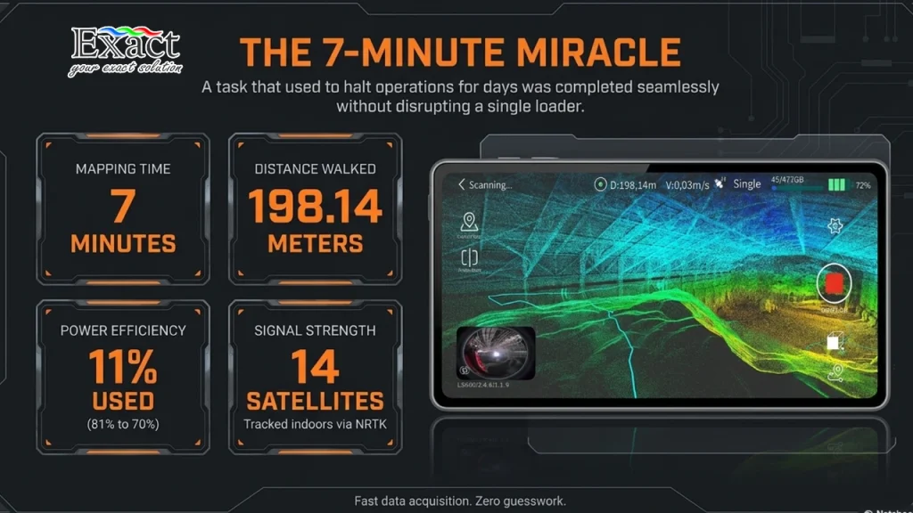
Halting heavy machinery for conventional stockpile surveys costs billions in lost productivity. The ComNav SinoGNSS LS600 revolutionizes volumetric mapping with a 100% cable-free, handheld 3D laser scanner that delivers centimeter-level accuracy in minutes. Discover how this rugged, IP54-rated device mapped a massive 198-meter facility in just 7 minutes with zero operational downtime.
Digitalization in Surveying: Optimizing Reality Capture and Real-Time Project Monitoring
Discover how Terrestrial Laser Scanners (TLS), automated monitoring, and BIM integration are revolutionizing the surveying industry for absolute project accuracy.
Leave behind slow and risky conventional measurement methods and step into a revolutionary new era of digital surveying. By harnessing cutting-edge technology, smart Terrestrial Laser Scanners (TLS) such as the Topcon CR-P1, ESN-100, and GLS-2200 can now capture real-world site conditions into highly dense 3D point clouds with incredible speed, safety, and zero physical contact
. This extreme-resolution reality capture data seamlessly integrates into Building Information Modeling (BIM) workflows using advanced software like ClearEdge3D Verity to automatically compare as-built point clouds with design data, allowing you to instantly detect structural clashes and verify construction accuracy
. Furthermore, the continuous safety of your most critical infrastructure—such as massive dam structures and mining slopes—can now be guaranteed 24/7 through autonomous, real-time monitoring systems
. By pairing the rugged precision of MSAXII Robotic Total Stations with MSP RAPID software, the system automatically collects data, filters out false readings, and delivers instant early warning alarms via SMS or email the moment any dangerous displacement is detected
. Ultimately, this powerful synergy of 3D reality capture, automated monitoring, and BIM integration ensures that your projects not only achieve remarkable time efficiency but are built upon an uncompromised foundation of absolute precision.