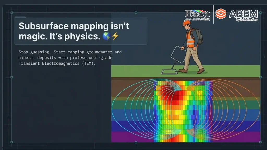
In the demanding landscape of Indonesian mineral exploration, time and operational compliance are critical assets. For decades, we at PT. Exact Global Teknologi have observed field teams in remote terrains struggling against nature—spending endless days clearing dense jungle vegetation, hauling hundreds of meters of heavy copper cables, and wrestling with massive transmitter loops through muddy swamps. By the time traditional instruments are set up, days of operational timelines have been consumed before collecting a single meaningful data point.
Today, strict regulatory shifts from the Ministry of Energy and Mineral Resources (ESDM)—including mandatory one-year Work Plan and Budget (RKAB) approval cycles and submissions through MinerbaOne—leave zero margin for logistical delays. To help your mining operations move forward without costly operational holds, we bring you a revolutionary approach: Walking TEM Indonesia powered by the ABEM GroundTEM Trek.
By replacing slow, static setups with an advanced, backpack-mounted continuous survey system, we empower your exploration crews to transition into a “plug-and-walk” workflow. Below, we outline 8 operational advantages of how our technology eliminates setup delays, cuts field survey times by up to 10×, and delivers real-time subsurface data across Indonesia’s most extreme environments.
1. Zero Line-Cutting: Eliminating the Heavy Logistics of Traditional Loops
Traditional Transient Electromagnetic (TEM) surveys require a moving-loop or fixed-loop setup. Laying out a standard 100m x 100m or 200m x 200m wire loop in dense Indonesian jungle terrain forces teams into extensive line-cutting.
The True Cost of Traditional Line-Cutting
- High Labor Requirements: Large crews are needed solely to clear vegetation using chainsaws and machetes.
- Safety & HSE Risks: Clearing jungle paths increases worker exposure to heat exhaustion, hazardous terrain, and wildlife hazards, elevating Lost Time Injury (LTI) metrics.
- ESG Compliance Issues: Tree cutting conflicts with modern Environmental, Social, and Governance (ESG) standards and demands additional forestry permits.
- Sluggish Progress: Laying, untangling, and retrieving thick ground cables through muddy swamps limits progress to just a few soundings per day.
TRADITIONAL TEM METHOD:
[Clear Jungle Paths] ➔ [Drag Heavy Cables] ➔ [Lay 100m x 100m Loop] ➔ [Take 1 Sounding] ➔ [Repeat](Result: High HSE risks, slow setup, high labor cost).
WALKING TEM “PLUG-AND-WALK” SOLUTION:
[Unpack Ransel] ➔ [Connect Wi-Fi] ➔ [Walk & Collect Continuous Data](Result: Zero line-cutting, 100% wireless, 10× faster field acquisition)
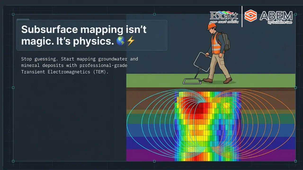
With our plug-and-walk exploration approach, line-cutting is completely eliminated. Your field operators carry the entire system on their backs. Instead of clearing wide corridors, two operators walk along natural paths, drill lines, or ridge lines—collecting high-density continuous data as they move.
2. Instant Mobilization: Eliminating Zero-Value Setup Time
In traditional geophysics, setup time is zero-value setup time—it consumes operational budgets without generating geological data. Setting up conventional ground TEM loops often takes 2 to 4 hours per survey site.
By contrast, the zero-setup geophysics time capability of the ABEM GroundTEM Trek gets your crews operational within minutes of arriving at the survey line.
SETUP TIME COMPARISON
|
Task |
Traditional Ground TEM |
ABEM GroundTEM Trek |
|
Unpacking Equipment |
30–45 Minutes |
5 Minutes |
|
Cable/Loop Deployment |
120–180 Minutes |
0 Minutes (Cable-Free) |
|
Calibration & Testing |
30 Minutes |
3 Minutes |
|
Mobilization to Next Line |
High Delay (Recoil Wire) |
Instant (Walk to Next Line) |
|
Total Setup Time |
2.5 to 4 Hours |
Under 10 Minutes |
The 4-Step “Plug-and-Walk” Mobilization Workflow
- Unpack: Remove the instrument units from their protective transit cases.
- Assemble: Snap the rigid transmitter and receiver coils into their backplate hinges, mount the control units, and plug in locking cables.
- Calibrate: Measure coil height above ground level and enter user heights into the control app.
- Walk: Power up, establish a local Wi-Fi connection to the Android control tablet, lock GNSS positioning, and start walking.
3. Ergonomic Dual-Backpack System Built for Extreme Terrains
Field conditions across Indonesia range from dense tropical rainforests and steep volcanic slopes to saturated coastal swamps. Equipment deployed in these environments must be lightweight, durable, and weather-resistant.
We supply the ABEM GroundTEM Trek with an ergonomic dual-backpack system designed to balance weight across the operator’s hips and shoulders.
DUAL-BACKPACK ARCHITECTURE
|
TRANSMITTER (Tx) BACKPACK |
RECEIVER (Rx) BACKPACK |
|
Weight: 15 kg |
Weight: 10 kg |
|
Role: “The Brain & The Pulse” |
Role: “The Listener” |
|
Components: |
Components: |
|
Battery: 14.4V RRC-2054-2 Li-ion |
Battery: 10.8V RRC-2040 Li-ion |
|
Runtime: ~80 minutes per pack |
Runtime: ~8 Hours Continuous |
Weatherproof and Ruggedized Hardware
Both the Tx and Rx backpacks feature high-impact ABS plastic enclosures with an IP67 rating. This IP67 guarantees that the hardware is completely dust-tight and fully protected against heavy tropical rain. Your field teams do not need to pause operations when torrential downpours strike, keeping fast subsurface mapping on schedule.
4. High-Density Continuous Logging: 10× Data Acquisition Speed
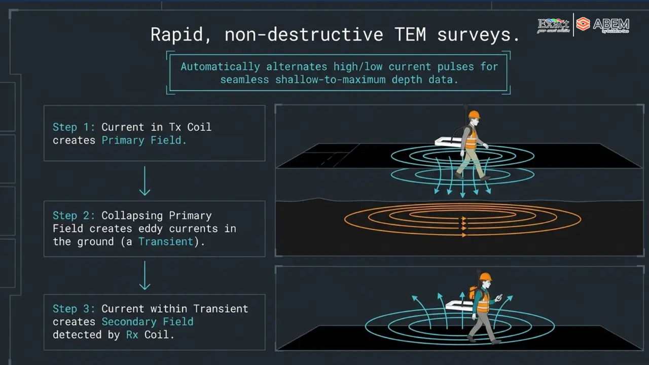
Traditional TEM surveys rely on static “point soundings”. Crews set up a loop, record data, pack up, move 50 meters, and repeat—resulting in sparse datasets with wide gaps between measurement points.
Our portable TEM method changes this completely by logging continuous data while operators walk at a natural pace of 3 to 4 km/h.
DATA DENSITY COMPARISON
| TRADITIONAL MOVING-LOOP TEM (Sparse Point Soundings) |
|
[Sounding 1] <———— 50m Gap ————> [Sounding 2] (Misses narrow, dipping geological structures and irregular laterite boundaries) |
| WALKING TEM CONTINUOUS LOGGING (High-Density Profile) |
|
[*][*][*][*][*][*][*][*][*][*][*][*][*][*][*][*][*][*][*][*][*][*][*][*][*][*][*]( Continuous data stream gives the equivalent of a 15-second sounding per meter) |
Signal Physics & Dual-Moment Transmitter
To capture both shallow soil structures and deeper geological horizons without manual re-configuration, the transmitter utilizes an intelligent dual-moment synthesis:
- Low Current (1 Amp): Fast switch-off time engineered to resolve high-resolution shallow features.
- High Current (10 Amp): High-energy pulse engineered to penetrate deeper horizons down to 50 to 100 meters.
The receiver platform captures returning magnetic signals at a massive 4 MHz sample rate across 1024 raw measurement gates, storing data directly to an onboard 128 GB solid-state drive. This rapid pulsing rate provides data density equivalent to a 15-second static sounding for every localized spot along your walking path. This high field data acquisition speed allows your team to map hectares of land in a single operational day.
5. Real-Time Subsurface Profiling: Inversion Results Directly in the Field
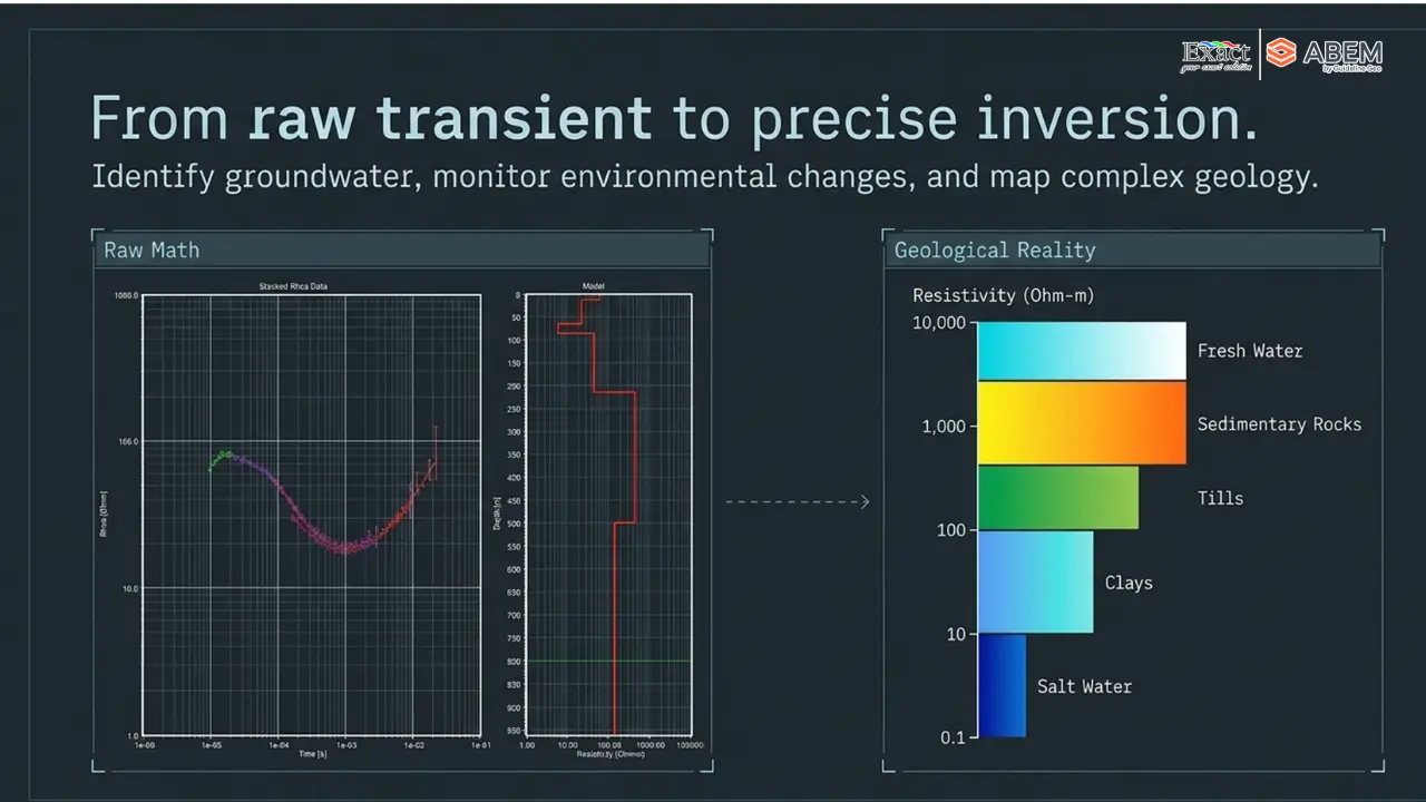
One major bottleneck in traditional geophysics is the long waiting period between field acquisition and office data processing. Raw files usually have to be transported to the office, cleaned of noise, and processed by senior geophysicists before anyone can visualize the subsurface geology.
We eliminate this delay through real-time subsurface profiling built into the ABEM GroundTEM Trek.
REAL-TIME DATA PIPELINE
[Raw Transient Signal] ➔ [4 MHz Board Capture] ➔ [ARM Cortex Averaging]
▼
[Android Tablet Interface] ◄── [Live Pseudo-2D Grid] ◄── [Automatic 1D Inversion]
How Live Inversion Works
- As your crew walks, the transmitter’s onboard ARM Cortex processor performs automated signal averaging.
- The system executes an automatic 1D inversion on the fly using a smooth mathematical model.
- Individual 1D models are stitched together seamlessly along the tracked GNSS path.
- The control app renders a live, color-coded pseudo-2D resistivity cross-section directly on an Android screen.
Your geologists can observe the Depth of Investigation (DOI), track conductive ore boundaries, and identify target anomalies instantly right on site.
6. Smart Quality Control: The Coil Distance Regulator
In a bistatic TEM system where transmitter and receiver units move independently, maintaining consistent separation between operators is critical for data integrity.
The ABEM GroundTEM Trek is optimized for a 10-meter nominal coil separation (with operators visually maintaining ~15 meters in the field). If operators drift too close together (under 5 to 6 meters), the receiver sensor becomes saturated by the primary magnetic field, recording inverted polarity data.
COIL DISTANCE REGULATOR ALERT SYSTEM
|
OPERATOR SPACING VISUAL BAR (On Android Control Screen) |
|
|
[ GREEN BAR: Optimal Spacing (10–15m) ] |
➔ Data acquisition proceeds normally. |
|
[ RED BAR: Operators Too Close (<6m) ] |
➔ • Android tablet vibrates |
This automated feedback loop ensures strict QA/QC standards without requiring your operators to drag physical distance ropes through thick underbrush.
7. Precision Targeting for Indonesian Nickel Laterite and Geotechnical Applications
Indonesia hosts world-class nickel reserves, primarily contained within nickel laterite exploration deposits created by deep weathering of ultramafic bedrock.
Mapping the Weathering Horizon
A typical nickel laterite profile consists of distinct physical horizons:
- Caprock / Iron Crust: Top layer, dry, composed of kaolinite clay with low Cation Exchange Capacity (CEC). Highly Resistive.
- Limonite Zone: Weathered horizon containing iron hydroxides and clay minerals. Conductive Target.
- Saprolite Zone: The primary economic nickel horizon, rich in smectite clays with high CEC and high moisture content. Highly Conductive Target.
- Bedrock / Unweathered Peridotite: Solid underlying rock matrix. Highly Resistive.
TYPICAL NICKEL LATERITE RESISTIVITY PROFILE
Surface ───────────────────────────────────────────────
[ Caprock Layer ] ──> HIGH RESISTIVITY ———————————————–
[ Limonite Zone ] ──> CONDUCTIVE ———————————————–
[ Saprolite Ore Zone ] ──> HIGHLY CONDUCTIVE (Smectite Clay) ———————————————–
[ Bedrock / Saprock ] ──> HIGH RESISTIVITY
Depth (100m) ──────────────────────────────────────────
Because the boundary between saprolite ore and bedrock is highly undulating, standard exploratory drilling on 40-meter grids often misses deep ore pockets or misreads bedrock pinnacles—creating expensive “blank spots”.
By capturing continuous electrical contrasts between resistive caprock and conductive clay horizons, our backpack TEM provides the lateral resolution needed to map uneven ore boundaries between drill holes accurately.
Multi-Purpose Applications
Beyond mineral exploration, the 50 to 100-meter depth penetration makes this equipment ideal for:
- Groundwater Mapping: Locating shallow aquifers for processing plants or local camp water supply.
- Geotechnical Engineering: Mapping bedrock topography, fault zones, and stability hazards for haul roads or tailings dam foundations.
8. Accelerated RKAB Compliance and Streamlined Field Operations
For mining concession owners in Indonesia, survey speed directly impacts regulatory approval and business continuity.
Under current ESDM guidelines, failure to update Feasibility Studies or geological models via MinerbaOne on schedule can result in operational shutdowns. Traditional geophysical surveys often become a bottleneck due to long acquisition times and extended office processing.
TRADITIONAL VS. WALKING TEM WORKFLOW
Traditional:
[Line Clearing: 14 Days] ➔ [Loop Survey: 21 Days] ➔ [Office Processing: 10 Days] = 45 DAYS Walking
TEM (Powered by ABEM GroundTEM Trek):
[Zero Setup / Direct Walk: 4 Days] ➔ [Real-Time Field Inversion: 0 Days] = 4 DAYS (10x Faster)
Adopting our walking TEM Indonesia workflow removes this operational bottleneck. Your crews map long profile kilometers in days, convert raw data directly into inversion models using software like TEMImage, AGS Workbench, or SPIA, and feed validated geological structures straight into your RKAB submission reports.
Operational Comparison Summary
|
FEATURES |
TRADITIONAL GROUND TEM |
ABEM GROUNDTEM TREK |
|
Primary Deployment |
Heavy Ground Cable Loops |
Dual-Backpack System |
|
Setup Mobilization |
2 to 4 Hours per Site |
Zero-Setup (<10 Minutes) |
|
Line-Cutting Needed? |
Yes (Labor-Intensive) |
No (Walk Natural Paths) |
|
Field Acquisition Speed |
0.5 to 1.5 km / day |
3 to 4 km / hour continuous |
|
Data Density |
Sparse Static Points |
High-Density Continuous Profile |
|
Field Visualization |
Raw Signal Decay Only |
Live Pseudo-2D Inversion Section |
|
Environmental Impact |
High (Clearing Vegetation) |
Zero Impact (ESG Compliant) |
|
Protection Rating |
Standard Enclosures |
IP67 Dust & Rainproof |
Frequently Asked Questions (FAQ)
Q1: How does Walking TEM achieve deep penetration without large wire loops?
Walking TEM utilizes a high-efficiency dual-moment transmitter firing rapid current pulses (1A and 10A). Combined with a sensitive receiver coil, a 4 MHz sampling rate, and advanced signal stacking, the system achieves a reliable depth penetration range of 50 to 100 meters using compact 0.65m x 0.65m rigid coils.
Q2: Can the ABEM GroundTEM Trek operate offline in remote jungle areas without cell coverage?
Yes. The control app running on the Android tablet connects directly to an offline, local Wi-Fi network generated by the main transmitter unit. Operators can pre-load offline background maps (georeferenced satellite imagery or topographic vectors in EPSG4326/EPSG3857 coordinates) into memory before entering remote concession sites.
Q3: How do operators manage battery power for full-day field surveying?
The receiver unit runs on a low-power 10.8V smart Li-ion battery lasting up to 8 hours continuously. The higher-power transmitter uses 14.4V batteries lasting approximately 80 minutes per pack. We supply the system with multiple swappable battery packs and a dedicated field charging suitcase, enabling non-stop all-day field acquisition.
Q4: How does the system handle electromagnetic noise from power lines or metal fences?
The control app displays live decay curves and signal polarity indicators in real time. If the survey approaches man-made metallic conductors (such as power lines or heavy machinery), the system alerts operators to negative polarity shifts or curve distortion. As an operational guideline, maintaining a 50-meter separation from major electrical infrastructure ensures clean data.
Q5: How is field data exported for final 2D/3D geological modeling?
At the end of a survey line, data files (.stb format) are transferred wirelessly via Wi-Fi using GroundTEM Connect software. These files export directly into standard geophysical interpretation software, including TEMImage, Aarhus GeoSoftware (AGS) Workbench, and SPIA, for final 2D and 3D geological modeling.
Partner with the Authorized Distributor in Indonesia
Implementing advanced geophysical technology requires dependable local support, certified instrument calibration, and comprehensive technical training.
Exact Global Teknologi is the authorized distributor for ABEM (by Guideline Geo) in Indonesia. We provide full technical consultations, field equipment demonstrations, software integration, and certified after-sales maintenance to help your exploration teams operate at peak efficiency in any terrain.
Contact Information
- Website: exactglobal.co.id
- Email Marketing: marketing@exactglobal.co.id
- WhatsApp Support: +62 812-9252-3900
Contact our technical team today to schedule a live field demonstration or technical consultation for your project.