ABEM GroundTEM Trek

Home > ABEM GroundTEM Trek

Tentang Produk

Mobile TEM Solution for Portable Groundwater and Environmental Mapping

ABEM GroundTEM Trek is a backpack-mounted transient electromagnetic (TEM) system designed for portable, rapid, and flexible groundwater and environmental mapping. Part of the ABEM GroundTEM product platform, Trek enables efficient subsurface investigations in areas that are difficult to access by vehicle-based TEM systems. GroundTEM Trek combines advanced TEM measurement technology with a lightweight, mobile configuration that adapts to rugged field environments and extensive terrain coverage.


GroundTEM Trek

GroundTEM Trek delivers reliable near-surface resistivity data while minimizing field setup time. Its compact transmitter and receiver modules allow continuous data acquisition while walking, making it ideal for surveys in remote areas, forested terrain, hills, and other environments where conventional TEM loop systems are impractical.

Equipped with GNSS positioning and altitude tracking, the system ensures accurate spatial referencing. Data can be visualized and monitored in real time through the GroundTEM Trek App, streamlining field quality control and decision-making.

Key Features

  • Intuitive Android Interface Operated entirely via the ABEM GroundTEM Pilot app on a rugged Android tablet. The familiar interface allows new operators to master the system quickly, while offering full control for experienced geophysicists.

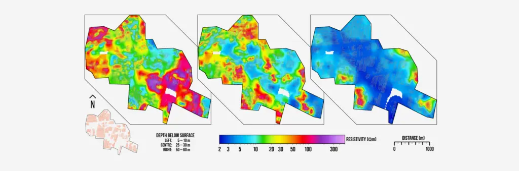
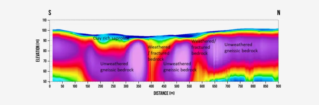
  • Real-Time Data Visualization (On-site Inversion) No need to wait until you return to the office. The system features integrated 1D inversion, allowing you to visualize subsurface resistivity models directly in the field for fast and accurate Quality Control (QC).

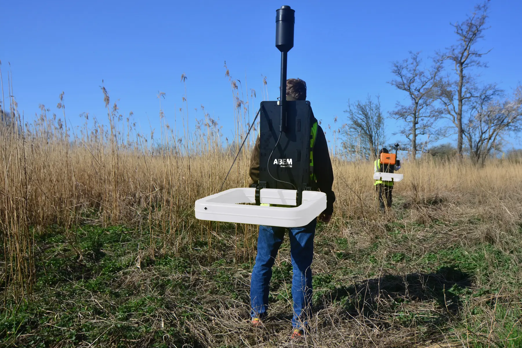
  • Rapid & Mobile Data Acquisition Designed for maximum time efficiency. The system supports continuous data collection while in motion (tow-mode), enabling significantly wider survey coverage in a single day compared to traditional static methods.

  • Fully Wireless Connectivity Communication between the transmitter, receiver, and tablet is handled seamlessly via Wi-Fi, Bluetooth, and internal GPS. This eliminates the hassle of tangled cables that often hinder operations in the field.

Instant Insights: Real-Time Data to 100 Meters Depth

The very portable GroundTEM Trek efficiently surveys anything from a single profile to large areas, providing detailed subsurface images, even in remote and rugged landscapes.

Don’t wait until you are back in the office to see what lies beneath. The ABEM GroundTEM Trek delivers high-resolution Transient Electromagnetic (TEM) data from the surface down to 100 meters (328 ft). Controlled entirely via a user-friendly Android app, the system offers real-time data processing and inverted models directly on your screen. This immediate feedback allows field teams to make on-the-spot decisions, quality-check results instantly, and adjust survey lines dynamically to capture the best possible data.

GroundTEM Trek App

Alongside the hardware, there is a software requirement for controlling the instrument. The GroundTEM Trek App is necessary for:

  • Configuring the instrument
  • Collecting data
  • Reviewing data
  • Visualizing maps and drawings
  • Navigation

It has a basic GIS-type presentation where multiple maps, figures and drawings can be uploaded and overlaid onto each other with or without transparency. 

The software paints a swath behind the system as data is collected.
Real-time processing of data – to produce an interpretable resistivity model in the field, instead of only looking at raw data – is available as a premium subscription feature.

Spesifikasi Teknis Terpilih

Application Area
Features
Resources
  • Rapid Groundwater Mapping: Ideal for large-scale aquifer mapping and delineating salinity interfaces while moving, significantly increasing productivity.

  • Geological Profiling: Efficiently map clay layers, bedrock depth, and stratigraphic variations over vast areas in a fraction of the time compared to static systems.

  • Environmental Monitoring: Fast detection of groundwater contamination plumes and monitoring of saline water intrusion across extensive coastlines.

  • Infrastructure Planning: Rapidly assess ground conditions for large-scale engineering projects like pipelines, roads, or railway corridors.

  • Towed acquisition system, design for high-speed, continuous data collection while being towed by an ATV or similar vehicle.
  • Dual-moment measurement.
  • High productivity, covering up to 30-50 km of suevey lines per day.
  • Real-time visualization.
  • Rugged towing rig.
  • Wireless control, integrated Wi-Fi for cable-free communication between the instrument, the operator, and the towing vehicle.
  • Precision GPS, high-accuracy integrated GPS with GLONASS support.
  • Flexible configuration.
Translate »