In the modern architecture, engineering, and construction industry, the demand for fast, reliable, and highly accurate spatial data forms the foundation of every successful project. We have seen traditional manual measurement methods slowly become outdated, making way for digital technologies that are vastly more efficient. One of the most important innovations leading this shift is the 3D laser scanner tool. This instrument has fundamentally changed how we plan designs, monitor construction progress, and execute site work.
Through this guide, we will explore the core functions of 3D laser scanning, including its integration with BIM (Building Information Modeling), and the emergence of cutting-edge terrestrial laser scanner (TLS) devices. Specifically, we will look at the capabilities of the Topcon ESN-100, an instrument designed so that anyone can perform high-precision measurements without mistakes and without confusion.
Here is our comprehensive list covering the ten main aspects of today’s 3D laser scanning technology:
Understanding the 3D Laser Scanner Tool and Point Clouds
A 3D laser scanner is a highly precise, non-contact instrument designed to capture the physical shape, size, and geometry of real-world objects and environments. Unlike standard cameras that merely capture surface color or two-dimensional images, this tool collects distance information from every surface within its field of view.
It works by projecting millions of laser beams onto surrounding objects within seconds. The reflections of these laser beams are then captured by the scanner’s sensors to generate a dense collection of three-dimensional spatial coordinates containing X, Y, and Z values. This massive dataset of millions of points is universally known as a point cloud. The density of the point cloud provides a highly accurate digital twin of the actual site conditions, allowing us to visualize complex geometries and contoured surfaces that were previously impossible to measure accurately.
Core Principles: How Laser Scanning Works
To fully understand how these devices replicate the real world digitally, we must look at the three primary measurement principles that dictate how laser scanning works.
- Time of Flight (TOF): This principle measures distance by calculating the exact time it takes for a laser pulse to travel from the scanner to the object and bounce back to the sensor. Because the speed of light is constant, the device can accurately determine the distance. This is highly effective for medium to long-range scanning, such as mapping highway corridors or large infrastructure up to 1,000 meters away.
- Phase-Shift: Scanners using this principle emit a continuous laser wave and calculate distance based on the phase difference between the emitted wave and the returning wave. We often see this utilized in short-range scanners requiring extreme acquisition speed and precision for detailed architectural interiors or industrial components.
- Triangulation: This method uses a camera and a laser beam positioned at a specific angle. The scanner calculates the distance using basic trigonometric principles based on where the laser reflection hits the camera’s sensor. This is ideal for capturing small-scale objects, historical artifacts, and high-resolution reverse engineering tasks.
Types of 3D Laser Scanners: From Terrestrial to SLAM-Based
We categorize 3D laser scanner platforms into four main types, depending on the project’s specific demands:
- Terrestrial Laser Scanner (TLS): These are statically mounted on tripods. Because they do not move during the scanning process, TLS devices like the Topcon ESN-100 offer the highest level of positional accuracy, making them the gold standard for inspecting detailed concrete structures, bridges, and building elements.
- Mobile Laser Scanner (MLS): Mounted on land vehicles, these systems scan road corridors dynamically. We use MLS to capture road conditions, markings, and right-of-way assets at normal driving speeds without disrupting traffic.
- Aerial Laser Scanner (ALS): These scanners are integrated into unmanned aerial vehicles (UAVs) or drones, either multirotor or fixed-wing. We utilize ALS to map massive topographical areas from altitudes of 300 to 2,000 meters, which is highly useful for highway planning and land acquisition.
- Portable Laser Scanner (PLS): These are compact, handheld, or backpack-mounted devices. They offer extreme flexibility and often utilize SLAM (Simultaneous Localization and Mapping) technology. SLAM algorithms allow the device to construct a map of its environment while simultaneously tracking its own location, which is invaluable when we are scanning underground spaces, mines, or GPS-denied areas.
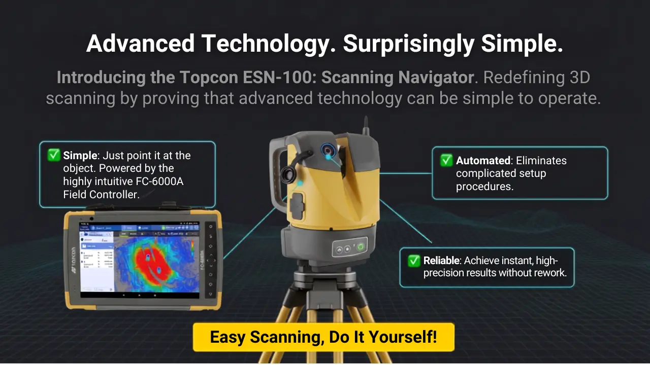
The Automation Revolution: “Just Place It” Technology
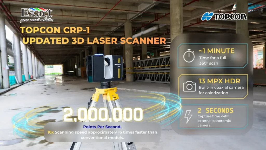
Historically, operating surveying equipment was complex and time-consuming. Technicians had to manually level the instruments using precision screws. Today, the latest trend is full automation, engineered to eliminate human error. The Topcon ESN-100 exemplifies this with its “Just Place It!” philosophy.
We simply place the device on a tripod and press a single button. The built-in Automatic Self-leveling mechanism automatically balances the instrument within a ±3° range. Furthermore, it features an Automatic Target Detection function that independently detects 360° reference prisms up to a distance of 100 meters. This absolute automation ensures that anyone on our field team, regardless of their surveying experience, can perform accurate 3D measurements. The system guarantees an operation with “No Mistake” and “No confusion”.
Millimeter Accuracy for Dimensional Quality Control
In large-scale infrastructure projects, the tolerance for design deviation is virtually zero. Today’s scanners are built to deliver millimeter accuracy to meet strict metrology standards. The Topcon ESN-100, for example, delivers exceptional precision. When the smoothing feature is activated on surfaces with a 90% reflection factor, it achieves a distance accuracy up to 4 mm and a coordinate accuracy of 5 mm at a 10-meter range.
This geometric precision is a vital component for automated dimensional quality control. With millimeter accuracy, any minor deviation between the constructed concrete structure and the original design blueprint is immediately detected, preventing fatal structural errors and costly rework later down the line.
Seamless Data Registration and Combining
One of the greatest challenges of older terrestrial laser scanner (TLS) workflows was the registration process—combining data from multiple scanner setup locations into one cohesive model. In the past, this required hours of manual overlap matching on a computer.
Modern devices solve this through field-based Resection methods. The scanner detects 360° prisms placed on known control coordinates. Once scans from various positions are complete, the system automatically aligns and combines all the point cloud data slices into a single, absolute global coordinate system. This removes the heavy burden of manual post-processing and ensures all data is perfectly stitched together on-site.
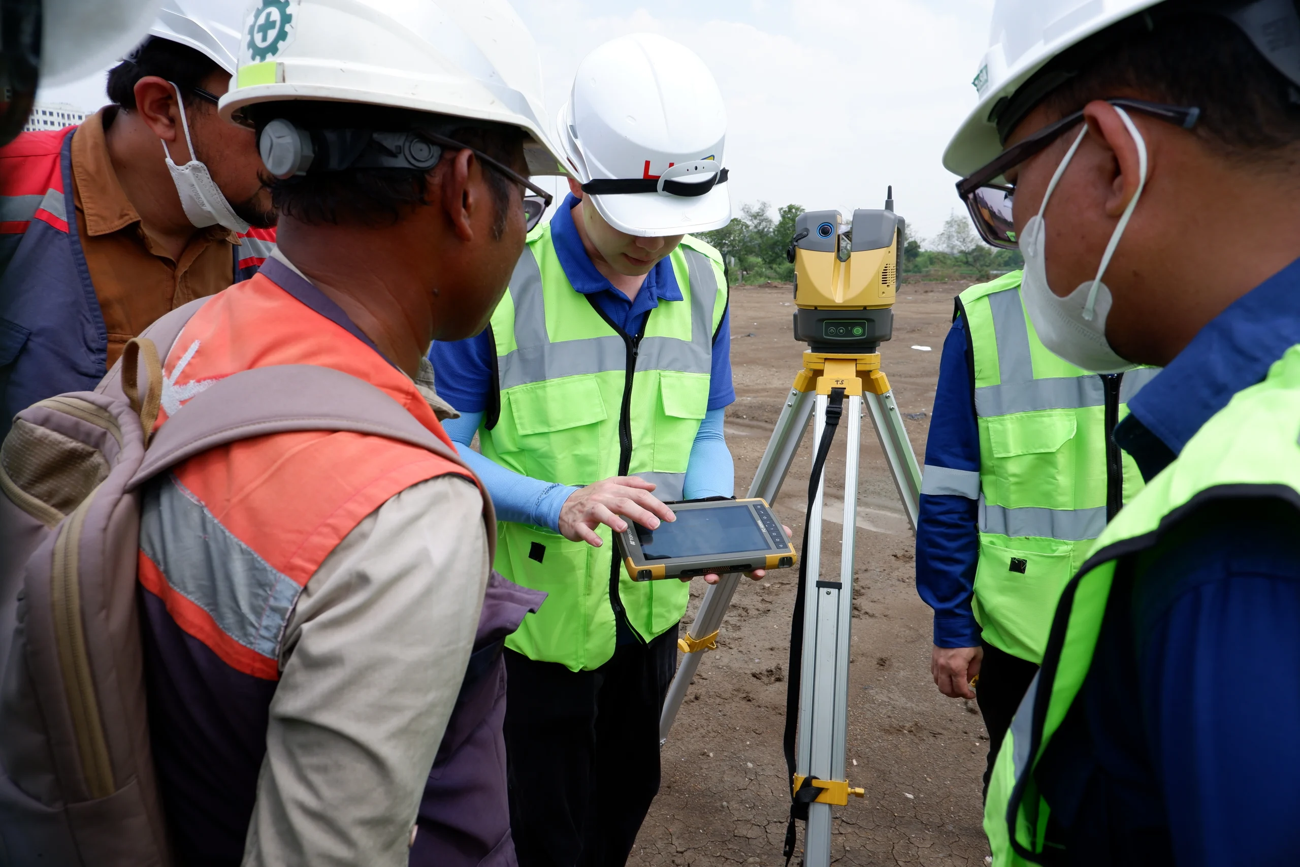
Field Adaptability: Remote Control and Real-Time Display
Operator safety and workflow flexibility are major focal points in current surveying trends. Operators using instruments like the Topcon ESN-100 no longer need to stand right next to the device. Using a wireless field controller tablet like the Android-based FC-6000A, we can remotely control the entire scanning process.
Through the dedicated Topcon Raster Scan software, we can monitor the scanning progress in real-time. This allows us to instantly review the 2D and 3D data on the screen to check for any missing spots or blind areas. If an area is missing, we can adjust and rescan immediately, preventing the need to return to the site another day.
Direct Integration with BIM Workflows
The true potential of point cloud data is unlocked when integrated with BIM. In modern project management, field scans are not just raw data. The latest scanners allow us to export registered data directly from the site in standard formats like LAS or TXT via a simple USB flash drive.
There is no need for lengthy post-processing just to generate the initial point cloud. We can import this data directly into our 3D CAD or office software to update the BIM model to reflect the actual as-built conditions. This synergy between the 3D laser scanner tool and BIM facilitates clash detection, structural tracking, and comprehensive facility management for building owners.
Smart Comparison: Progress Monitoring and Earthwork Volumes
Based on modern infrastructure management guidelines, this technology plays a pivotal role in every stage of the project lifecycle. A major benefit is the smart comparison function.
We can monitor physical progress daily. The smart comparison tools allow us to compare today’s scan data with yesterday’s scans or against the 3D design data. For example, after earthmoving operations, we can scan the ground elevation and instantly calculate the cut-and-fill volume. This makes calculating earthwork volumes transparent and highly accurate, removing the guesswork from field reporting.
Rapid Conversion to Engineering Deliverables
Once the massive point cloud datasets are collected, they must be converted into usable engineering deliverables. Software like MAGNET Collage Office is lightweight yet highly powerful, capable of importing multi-gigabyte files effortlessly. The software allows us to generate deliverables with a single click, including:
- Digital Elevation Models (DEM): A continuous surface model mapping exact topography.
- TIN Mesh: A lightweight 3D surface model consisting of interconnected triangles, ideal for grading analysis.
- Automated Contours: Topographic contour maps extracted automatically, eliminating hours of manual drafting work.
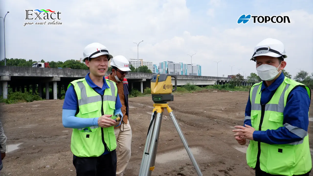
Case Study: High-Efficiency Performance at the NPEA Project
To provide empirical evidence of these capabilities, we highlight a real-world demonstration conducted at the North Priok Eastern Access (NPEA) project in 2026. The test evaluated the field efficiency, data capacity management, and spatial coordinate reliability of the Topcon ESN-100 combined with MAGNET Collage Office software.
We tied the scanning network to two main control benchmarks (BM_HAP_12 and IC1) using 360° prisms. We tested two distinct operational modes:
- Standard Efficiency Mode: The instrument captured data at an 11mm point density, completing a full station sweep in just short time. The resulting files were highly optimized at around 300 MB per station, which remarkably included full 360° panoramic imagery.
- High-Resolution Mode: Adjusted for a tighter 5mm density, the scan was completed in short time, producing a 1 GB high-definition dataset.
During post-processing, MAGNET Collage Office flawlessly imported, colorized, and registered over data on a standard office laptop. The final registration accuracy was exceptional; the horizontal and vertical Root Mean Square (RMS) residuals consistently remained under 5 mm across all valid stations (for example, Station S2 showed a vertical RMS of just 0.2 mm). This rapid, sub-5mm accuracy proves that investing in a professional 3D laser scanner yields massive returns in terms of saved survey hours and guaranteed precision.
About Us: PT. Exact Global Teknologi
As a pioneer in spatial engineering instrumentation, we at PT. Exact Global Teknologi are dedicated to providing the mapping, construction, and asset digitalization products you can rely on. Bringing technical partnership portfolios from renowned global brands like Topcon, our engineering team is ready to be your bridge to maximum efficiency for infrastructure projects of any scale.
- Website: ww.exactglobal.co.id
- Email Marketing: marketing@exactglobal.co.id
- WhatsApp: +62 812-9252-3900
FAQ Section: Everything You Need to Know About 3D Laser Scanners
-
Why do modern construction projects need a 3D laser scanner tool instead of a conventional Total Station?
A conventional total station measures a single elevation point at a time, requiring the operator to manually select important building features. Conversely, a 3D laser scanner sweeps the entire area instantly, capturing up to 200,000 points per second. It produces a dense visual model called a point cloud. It copies the complete physical reality into the computer without missing any critical components, heavily supporting BIM ecosystems.
-
Is “Millimeter Accuracy” truly mandatory for modern construction work?
Yes, it is strictly mandatory. In the construction of bridges, toll roads, and steel-reinforced buildings, dimensional deviations of just a few centimeters can lead to dangerous structural failures and extensive reworking costs. Modern terrestrial laser scanner (TLS) instruments like the ESN-100 guarantee standard deviations as low as 3 to 5 millimeters, allowing us to execute quality control and dimensional inspections with absolute precision that meets tight technical tolerances.
-
Does processing massive point cloud data require companies to buy extremely expensive workstation computers?
Not necessarily. While IT hardware investment is a common concern, modern processing software like MAGNET Collage Office is built with highly optimized, lightweight architecture. It can smoothly process multi-gigabyte datasets (such as 3.6+ GB) using standard office laptops. The minimum recommended specifications are just an Intel Core i7 processor (4 cores), 8GB of RAM, and a discrete GPU with at least 512 MB VRAM.
-
How does the scanner assist in physical progress reporting for cut-and-fill volumes?
Smart devices today connect directly to field software controllers, such as Topcon Raster Scan. We can store yesterday’s ground elevation scan data and overlay it with today’s scan after excavation machinery has worked. The system instantly compares the surfaces, and with built-in volume calculation functions, the cut or fill volume is presented accurately and transparently, completely eliminating manual measurement bias.
-
Can this technology operate effectively in extreme, hard-to-reach mapping areas?
The latest generation of 3D laser scanners is designed to be highly portable and durable. Leading TLS instruments weigh only around 4.8 kg, feature ergonomic handles, and can be transported safely in protective backpacks. This allows personnel to carry them across steep mountainous worksites effortlessly. Furthermore, for areas completely out of reach, Aerial Laser Scanners (ALS) and Portable Laser Scanners (PLS) ensure every corner of your project is mapped without compromising team safety.