Imagine sitting in your office, reviewing a structural survey report that just arrived on your desk. The Excel sheet shows a 3 mm shift on the dam’s main concrete face. As a project owner or director, this number forces you to make a heavy choice. Do you sound the alarm, halt operations, and lower the water levels? Or do you assume it is just an error from the field equipment?
Here is the worst part: the report in your hands is already 48 hours old. If the dam was actually shifting, you are two days late to the problem. You cannot make billion-dollar emergency decisions based on delayed guesswork. At Exact Global, we see executives face this exact risk every single week.
In this guide, we will break down the fatal flaws in conventional surveying and show you how a fully automated dam monitoring system with the Topcon MS AXII secures your assets, cuts operational expenses (OPEX), and delivers sub-millimeter facts in real-time.
The Root of the Problem: Why is Your Data Delayed and ‘Jumping’?
To mitigate infrastructure risks, you must recognize two major flaws in your current conventional survey workflow:
The Manual Data Chain and 48-Hour Data Lag
Relying on manual field surveys means your data must be gathered by hand, typed into spreadsheets, processed, and finally sent to your office. If a severe storm causes sudden ground settlement on a Tuesday night, your field team might not measure it until Wednesday morning. You will not see the report until Thursday. By the time you see the problem, the window for a safe emergency response might already be closed.
Extreme Field Conditions and Data “Noise”
When you look at a deformation graph, you want to see a flat, clean line if the dam is stable. Instead, manual surveys often produce graphs that jump up and down by 2 mm to 4 mm. We call this “data noise”. Why does this happen?
- Valley Winds: Dams are typically built in valleys. When a strong gust hits a standard total station on a concrete pillar, the internal compensator (the part that keeps the laser level) shakes. This tiny vibration completely ruins the measurement.
- Temperature Shifts & Fog: In the morning, the air is cold and thick with fog. By noon, the sun heats the concrete face of the dam, creating heat waves (refraction) that bend the laser beam. Standard equipment loses the target prism or records the wrong distance.
Executive Insight: Eliminating data noise and reporting delays is not just an engineering task; it is a critical risk management protocol.
The Solution: Moving from Manual Surveys to Real-Time Robotics
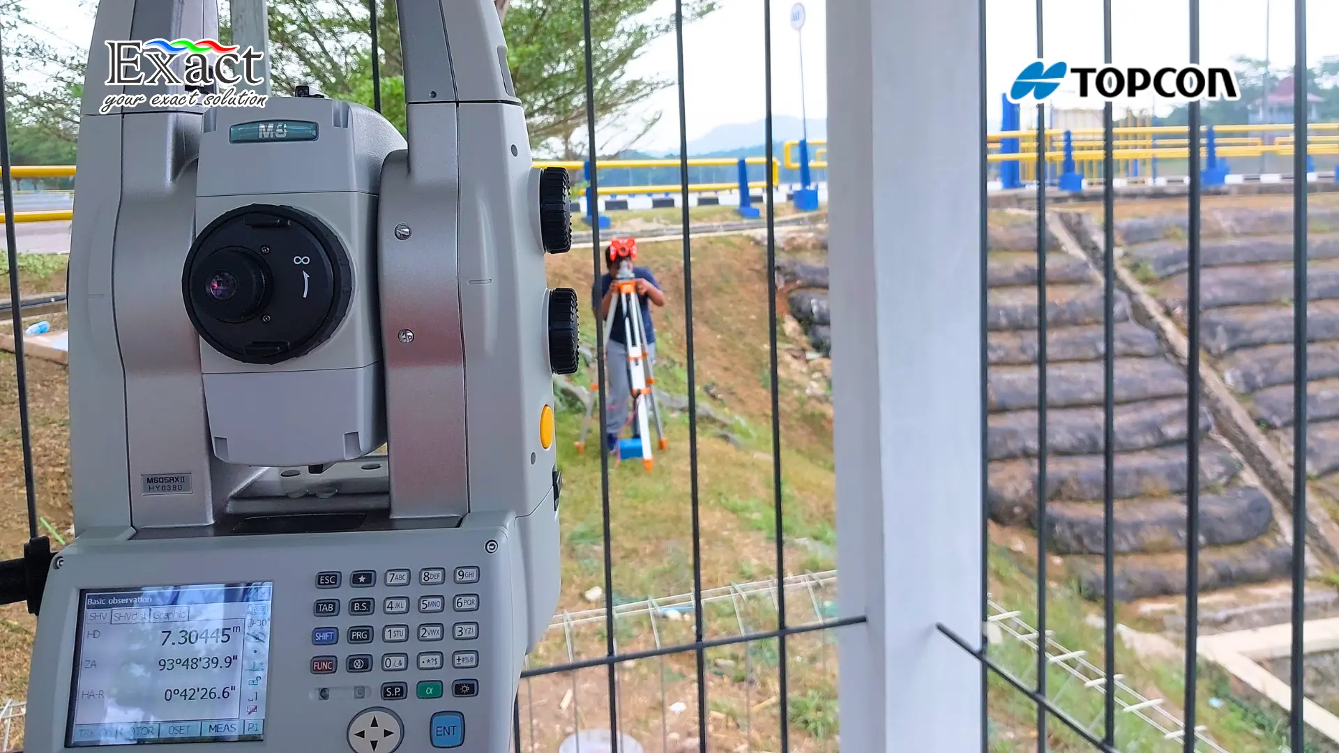
To eliminate data lag and guesswork, the only solution is moving to full automation. By setting up the Topcon MS AXII as a fully automated robotic total station dam monitoring system, you remove the human element entirely. Here is how the Topcon MS AXII secures your data integrity:
Sub-Millimeter Certainty (0.5″ Accuracy)
The Topcon MS AXII is an industrial-grade monitoring robot built specifically for high-risk infrastructure. It features an angular accuracy of 0.5″ (arc-seconds) and a distance accuracy of 0.5 mm. In simple terms, this machine is so precise that if it tells you the concrete moved by 1 mm, you can treat that as a verified fact, not a tool error.
Conquering Extreme Weather
- Rapid Compensator: Dam valleys are incredibly windy. When wind hits the Topcon MS AXII, its internal dual-axis compensator instantly detects the vibration and corrects the laser angle before it takes the shot.
- Matrix Tracking Technology: Fog, morning mist, and heavy dust are normal at any large dam site. The MS AXII uses a specialized algorithm to cut through low-contrast environments. It securely locks onto the center of the prism and extracts the measurement when standard tools fail.
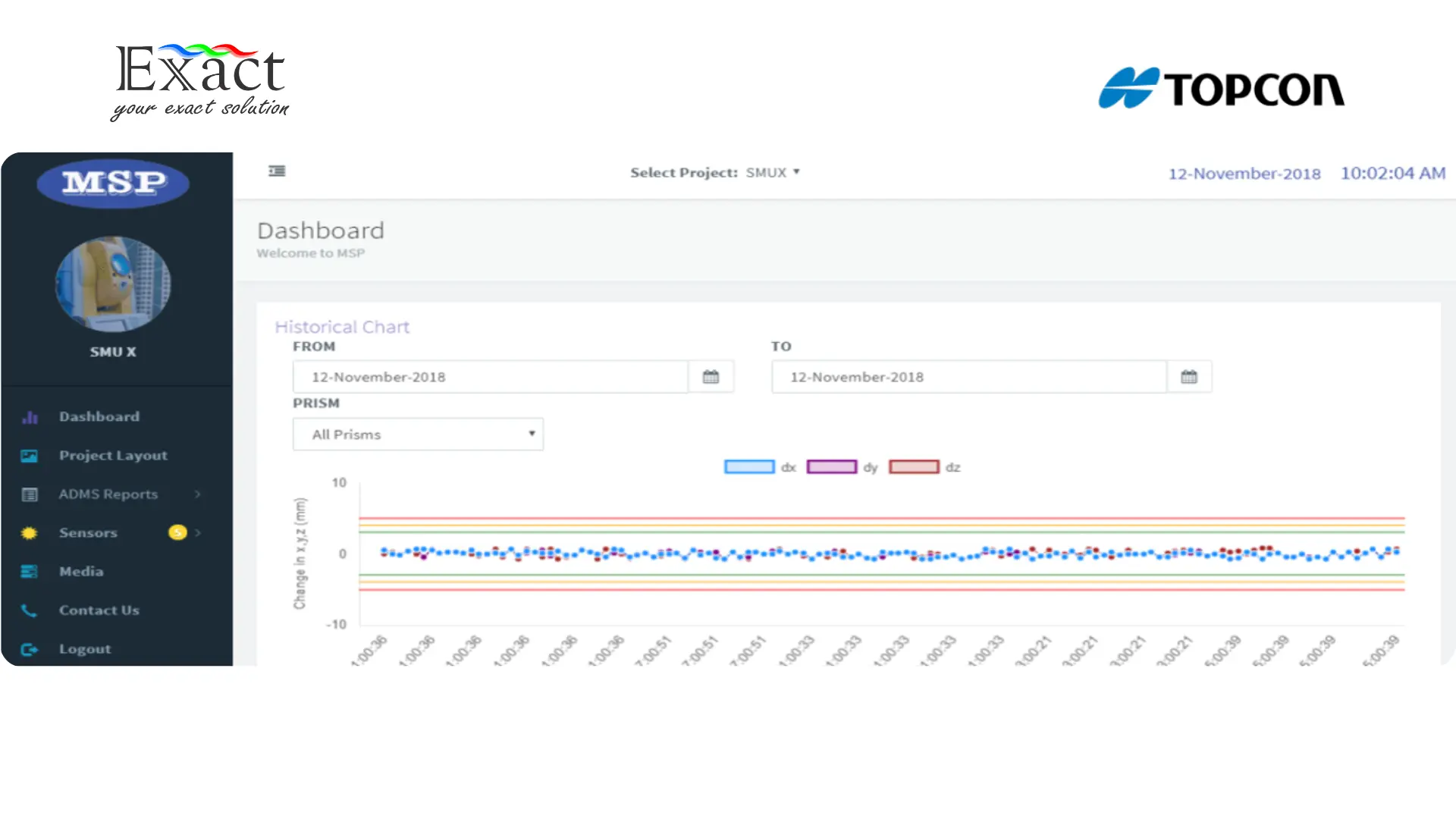
Executive Live Dashboard (Zero Delay)
We program the unit to wake up every hour, scan 50 different prisms across the dam structure in the exact same sequence, record the data, and go back to sleep. The moment the robot finishes scanning the dam, the data is pushed to a secure cloud server. You can open your laptop in Jakarta and see the exact structural health of a dam in Papua in real-time. If there is a sudden movement at 2:00 AM, the system detects it at 2:01 AM. The 48-hour delay drops to zero.
The Business Math: ROI and Risk Mitigation
Many executives hesitate to upgrade to a robotic system because the initial hardware purchase is higher than buying standard manual tools. However, when we break down the operational math, the return on investment (ROI) becomes impossible to ignore.
- Slashing Heavy OPEX, If you use manual surveying, you have to pay a team of surveyors, provide them with transportation to remote dam locations, pay for their accommodation, and cover high-risk work insurance. These operational expenses (OPEX) drain your budget continuously. When we install a Topcon MS AXII, you replace that entire recurring monthly cost with a single, one-time capital expenditure (CapEx). The robot works 24 hours a day, 7 days a week, 365 days a year. Within the first year to 18 months, the savings in OPEX completely cover the cost of the equipment.
- Multi-Million Dollar Disaster Insurance ,The true ROI, however, lies in risk mitigation. If a dam breaches because your manual team missed an early warning sign, the financial damage to the surrounding infrastructure, the emergency reconstruction costs, and the legal liabilities will easily reach hundreds of billions of Rupiah. Catching a 2 mm shift early allows you to perform a minor repair for a fraction of the cost.
Comparison Summary: Standard System vs. Topcon MS AXII
|
Feature/Metric |
Standard Total Station |
Topcon MS AXII 0.5″ |
|
Data Quality |
High noise, fluctuating graphs |
Smooth, linear, reliable trends |
|
Wind Resistance |
Poor (vibrates easily) |
Excellent (rapid auto-correction) |
|
Targeting in Fog |
Frequently loses the target |
Matrix Tracking locks on securely |
|
Data Delivery |
Manual, delayed by days |
Real-time, instant cloud access |
|
Labor Cost |
High (requires daily field teams) |
Low (fully automated 24/7) |
|
Decision Making |
Guesswork and doubt |
Confident, data-driven action |
Frequently Asked Questions (FAQ)
1. Is an automated dam monitoring system recognized by government safety regulations?
Yes. In fact, regulatory bodies in Indonesia heavily encourage and increasingly mandate automated, real-time data collection for major infrastructure. Our systems are fully compliant with the national dam safety commission standards, ensuring your project passes all technical audits seamlessly. They can also easily integrate with customized real-time dashboards required by national dam safety regulations (like Sistem Monitoring Stabilitas Bendungan).
2. What if the internet connection at our dam site is completely dead?
This is a very common issue in remote areas. Our systems do not rely solely on standard cell towers. We can integrate the Topcon MS AXII with specialized radio telemetry or satellite internet gateways. Even in the deepest valleys, we guarantee that your data will reach your dashboard in Jakarta.
3. We already have a team of surveyors on site. What happens to them?
-
Automated monitoring does not replace your engineering intelligence; it replaces the tedious, high-risk manual labor. Your surveyors will no longer waste days collecting basic numbers in the rain. Instead, they will transition into data analysts, using the real-time facts provided by the Topcon MS AXII to plan maintenance and improve structural safety.
Secure Your Dam and Your Data Today
The era of waiting days for an Excel report is over. As an executive, your primary job is to manage risk and protect your investments. You can no longer afford to make critical safety decisions based on delayed, noisy data. At Exact Global, our geodetic engineers design, install, and calibrate the entire automated network to fit the specific geography of your dam.
You transition from reactive guessing to proactive management.
Learn more about the tool specifications and schedule an equipment demo with our team today.
📩 Email: marketing@exactglobal.co.id
📞 WhatsApp: +62 812-9252-3900


