We all know the drill. You get to the job site early, set up the tripod, and spend the first 20 minutes just trying to get the bubble level perfectly centered. Then, you spend the rest of the day shouting over the noise of excavators, trying to tell your rod man to move “two centimeters to the left.”
It is slow. It is frustrating. And honestly, we are tired of it.
That is why we switched to the Topcon LN-160. It is a robotic layout tool that changes how we work, not because it is “futuristic,” but because it is simple. It lets us do the job alone, and it sets itself up. Here is how we use it to get our layout work done faster.
The “One-Man Army” Advantage
The biggest reason we like this tool is that it turns layout into a one-person job. Usually, you need one person standing at the instrument and another holding the prism rod. With the LN-160, the machine does the watching. It locks onto the prism and follows you automatically. You just hold the pole and your phone. The instrument tracks you constantly updating 20 times a second so as you walk across the site, the coordinates on your screen are always right.
This means we don’t need a second guy standing around waiting for instructions. He can go do something else, and we get the layout done without the shouting match.
Setup That Actually Makes Sense
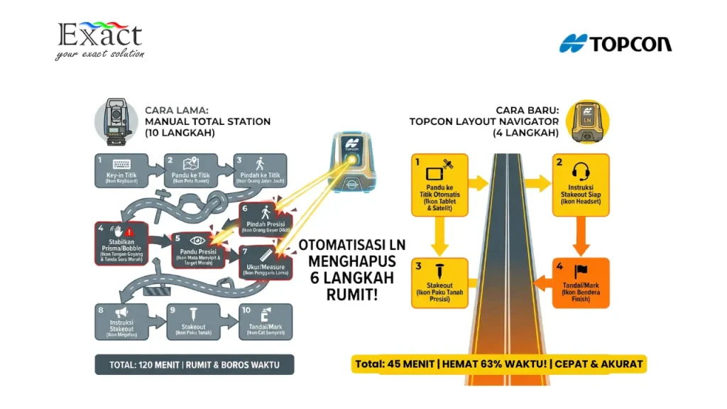
If you have ever kicked a tripod leg by accident and had to start leveling all over again, you will appreciate this. The LN-160 has Self-Leveling.
Here is our morning routine now:
- We put the instrument on the tripod. We don’t stress about making it perfectly flat—as long as it is within 3 degrees of level, it works.
- We hit the power button.
- We wait a few seconds.
That’s it. The machine uses internal sensors to find level and adjusts itself automatically. We don’t look at a bubble level; we don’t twist foot screws. It just works. If the instrument gets bumped, it warns us so we don’t layout bad points.
Use the Phone You Already Have
We used to spend a fortune on those rugged data collectors that looked like bricks. The LN-160 is different because it works with Android. We just use a standard Android phone or tablet. We downloaded the control app, TopLayout, for free from Google Play. It handles everything we need: setting up the instrument, measuring points, and guiding us to the layout spots. When we are done, we don’t need to drive back to the office to plug in a cable. We just email the data or upload it to the cloud right from the phone.
Handling Hills and Deep Trenches
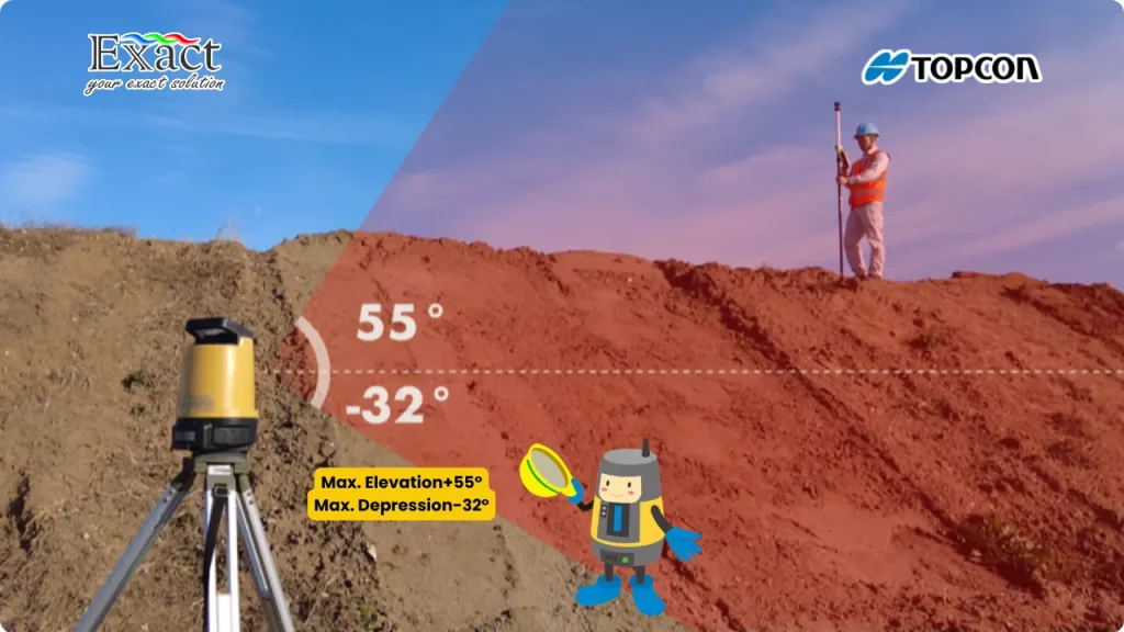
Our sites are rarely flat. We often have to shoot points into a deep excavation or up a steep embankment. The LN-160 has a massive vertical range. It can look up to +55 degrees and down to -32 degrees. This is a huge help when we are setting up close to a building or a pit. We don’t have to constantly move the station further back just to see the prism. For distance, it reaches out to 130 meters. That gives us a working circle of 260 meters, which is enough to cover most of our infrastructure or building pad sites without moving the station.
The “Green means Go” Lights
Training new guys to find a point used to take time. The LN-160 makes it dead simple with Guide Lights. The machine shoots out colored lights that you can see from the rod.
- If you see Green, you move right.
- If you see Red, you move left.
Once you see both colors or the center light, you are on the line. It cuts down the time we spend wandering around trying to find the “line” before we start fine-tuning the measurement.
Power for the Whole Shift
Nothing kills a day faster than a dead battery. The LN-160 comes with two batteries in the box. Each one lasts about 6 hours. Since we have two, we can swap them out and easily get through a 12-hour shift. But here is a cool feature on the LN-160 model: it has an external power port. If we are on a remote site with no way to charge batteries, we can hook the instrument directly to a car battery using a cable. It gives us peace of mind knowing we won’t run out of juice in the middle of a concrete pour.
Is It Tough Enough?
We are hard on our gear. It gets dusty, and it rains. The LN-160 is rated IP65. This means it is dust-tight and can handle water jets from any direction. We don’t panic if a sudden rain shower hits or if the wind kicks up a cloud of dust.
The Bottom Line
We switched to the Topcon LN-160 because it solves the actual problems we face every day: complex setups, needing extra hands, and fighting with equipment. It is straightforward, tough, and lets one person do the work of two.
If you want to stop fighting with bubble levels and start getting points on the ground faster, this is the tool to use.
At PT. Exact Global Teknologi, our job is to make sure you have the best gear and the right knowledge to use it. Because when you eliminate the guesswork from your layout, the complex becomes simple. Let’s get to work.
PT. Exact Global Teknologi Authorized Distributor of Topcon in Indonesia Simple. Accurate. Professional.