Apa Itu Monitoring Deformasi?
Monitoring deformasi adalah proses pengukuran pergerakan atau perubahan posisi sebuah objek atau area dari waktu ke waktu. Umumnya dilakukan pada:
- Jembatan
- Bendungan
- Terowongan
- Lereng tambang
- Gedung tinggi
- Tanah lunak
Tujuannya untuk deteksi dini pergerakan berbahaya sebelum memicu kerusakan atau kecelakaan fatal.
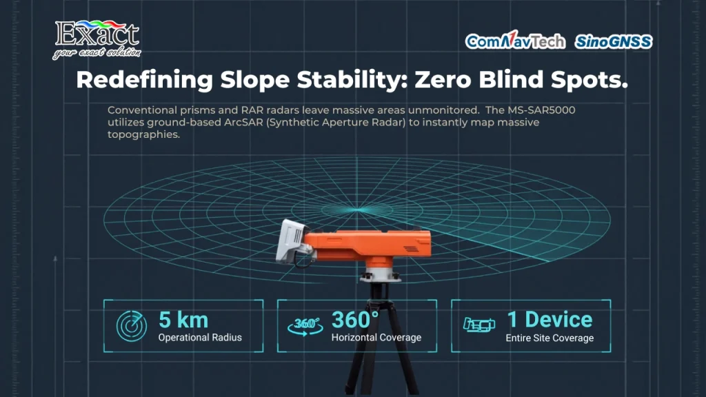
Mengapa Akurasi 0.5mm Itu Penting?
Dalam proyek infrastruktur dan pertambangan, toleransi kesalahan sekecil 1-2mm saja bisa berdampak besar. Akurasi 0.5mm + 1ppm dari TOPCON MS AXII menjadi standar monitoring deformasi untuk:
- Menjamin keamanan area kerja
- Memenuhi standar teknis proyek skala nasional dan internasional
- Memberikan data valid untuk riset akademik
Mengenal TOPCON MS AXII


TOPCON MS AXII adalah Robotic Total Station ultra presisi untuk kebutuhan deformation monitoring. Alat ini memiliki berbagai keunggulan, antara lain:
- Akurasi jarak hingga 0.5mm
- Auto-pointing & auto-tracking presisi
- Mampu bekerja remote monitoring via PC
- Durabilitas IP65, tahan air-debu dan suhu ekstrem
- Kompatibel untuk monitoring 24 jam non-stop
Spesifikasi Unggulan TOPCON MS AXII
| Fitur | Keterangan |
| Akurasi EDM | 0.5mm + 1ppm (reflektif sheet) |
| Akurasi Sudut | 0.5 detik (MS05AXII) / 1 detik (MS1AXII) |
| Jarak Prism | Hingga 3.500m |
| Jarak Reflectorless | Hingga 400m (90% reflective) |
| Auto-Pointing Accuracy | 1mm @200m |
| Prescan Reflector | Auto search area gelap/minim cahaya |
| IP Rating | IP65 |
| Suhu Operasi | -20°C hingga +50°C |
Kenapa TOPCON MS AXII Lebih Dipilih?
- Presisi Ultra Tinggi
Menghadirkan akurasi hingga 0.5mm, sangat cocok untuk proyek kritikal yang tidak boleh salah.
- Remote Monitoring
Bisa dikendalikan dari kantor, tanpa perlu ke site berbahaya. Ideal untuk tambang terbuka dan jembatan.
- Auto-Pointing Canggih
Otomatis mendeteksi target prism meskipun banyak objek reflektif di area pandang.
- Durabilitas Tinggi
Bekerja nonstop di cuaca ekstrim, hujan-debu, suhu -20°C sampai +50°C.
- Prescan Reflector
Setup awal monitoring jadi cepat, bahkan di lokasi gelap total.
Aplikasi Ideal TOPCON MS AXII
Infrastruktur
- Monitoring deformasi jembatan, bendungan, dan terowongan
• Deteksi dini retakan dan pergeseran struktur
Pertambangan
- Monitoring lereng tambang terbuka jarak jauh
• Data deformasi real-time tanpa operator onsite
Pendidikan & Riset
- Riset deformasi tanah, slope stability, dan struktur
• Riset untuk dosen aktif, tugas akhir mahasiswa Teknik Sipil & Geodesi
TOPCON MS AXII adalah solusi alat monitoring deformasi paling presisi saat ini, ideal untuk sektor:
- Infrastruktur
- Pertambangan
- Pendidikan Geoteknik
Dengan kemampuan remote monitoring 24/7, presisi ultra tinggi, dan sistem auto-pointing canggih, alat ini menjaga proyek-proyek besar tetap aman dan terkendali.
Ingin Konsultasi Sistem Monitoring Proyek Anda?
Hubungi kami untuk demo langsung di site proyek atau kampus Anda!
Whatsapp: +62 812-9252-3900 | Email: info@exactglobal.co.id
Website: localhost/exactglobal.co.id/