Roads and runways are like the water in our cities: we all use them every day, and we always expect them to be available and safe. Mobility gives us freedom, and we rely on good infrastructure to keep our lives and economies moving. However, road infrastructure is often the largest investment in any government or organizational budget. For those of us in charge of maintaining these assets—such as C-Level executives, Heads of Public Works (Kadis PUPR), and Airport Maintenance Directors—managing these budgets while preventing fatal losses is a daily challenge.
The planet is not short on roads, but we face heavy challenges related to quality, congestion, and safety. We see increasing loads from heavy traffic and harsh weather, which tear down our pavement faster than before. A good part of traffic congestion is linked to long, invasive road repairs that happen because of poor early maintenance.
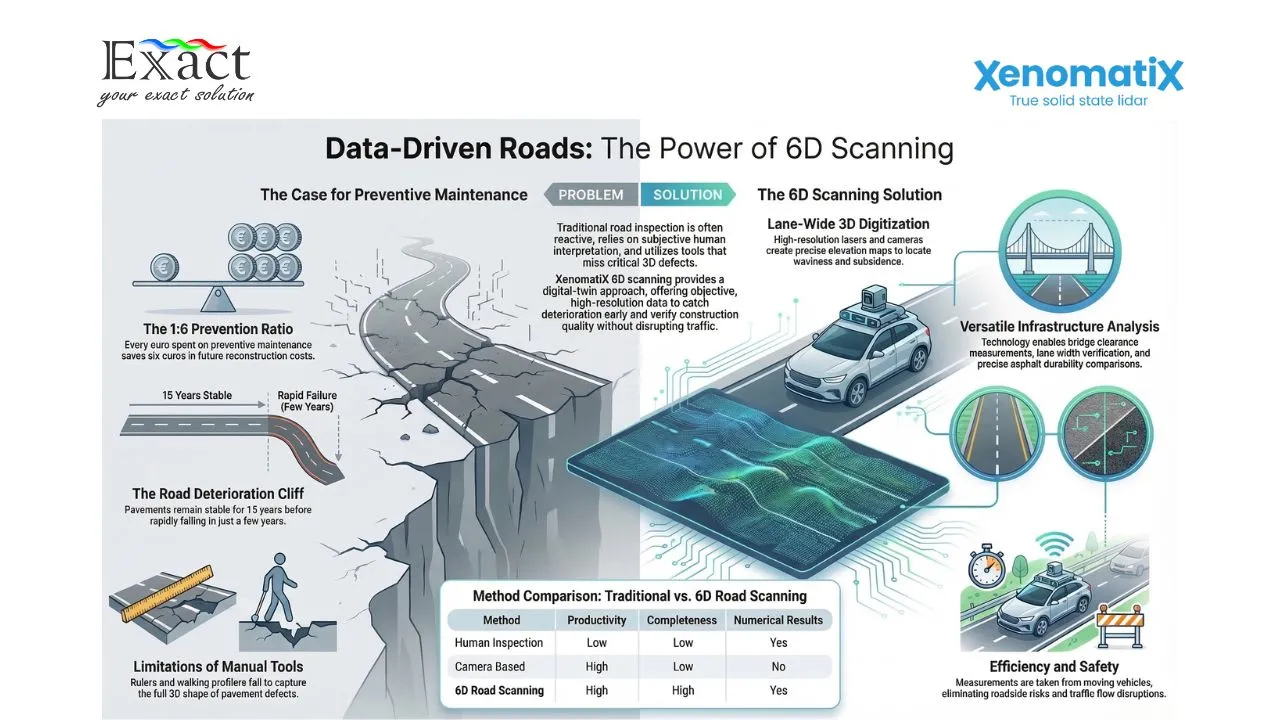
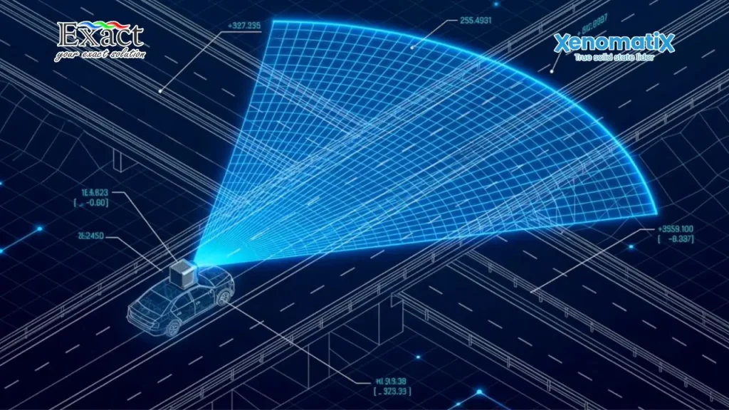
To solve this, we must shift how we inspect our infrastructure. Using a Mobile Mapping System, specifically through advanced 6D road scanning and true solid-state Lidar, gives us the data we need to act before disasters happen. Here are the top ways millimeter-accurate mapping prevents fatal risks and huge financial losses for our infrastructure networks.
1. Stopping Financial Drain with Preventive Maintenance
A road or runway typically has an average lifetime of about 30 years. For the first 10 to 15 years, the pavement stays in good condition. But after that point, the quality drops rapidly in just a few short years. Once this fast deterioration starts, we are forced to pay for very expensive reconstruction. Because these late repairs cost so much, maintenance is often delayed, leading to dangerous, low-quality roads.
We can stop this financial drain by understanding exactly where a road is on its deterioration curve. Studies show that every dollar or euro we spend on early, preventive preservation saves up to six dollars on heavy rehabilitation later. In total, proper preventive maintenance reduces the total cost of ownership of a road by 25% to 30%. By using a Mobile Mapping System Indonesia to take periodic snapshots of the road, we know exactly when and where to spend our limited budgets before the pavement enters its rapid decline.
2. Finding Hidden Foundation Problems Early
Road damage usually starts from two main causes: foundation problems or traffic loads. Foundation problems are the most destructive. They cause cracks and subsidences. When the foundation fails, the top layer opens up, allowing water to enter. Once water gets inside the pavement, the damage speeds up quickly, especially during heavy rains or winter seasons.
Traditional visual inspections by humans often miss these early signs. Human inspectors walk or drive the road, but they cannot measure the true 3D shape of a hidden subsidence. By using a system like XenoTrack, we scan the road from gutter to gutter with high resolution. The system creates an elevation map that shows exact areas where the road is sinking below the average surface. We can find these hidden subsidences and seal the cracks or repair the foundation before water completely destroys the road.
3. Keeping Workers and Traffic Safe During Inspections
Sending human inspectors out with tape measures or rulers is slow, imprecise, and highly dangerous. Having personnel walk along high-traffic highways or active airport runways puts lives at risk.
Our inspection method removes this risk completely. Measurements are taken from a moving vehicle driving at normal traffic speeds, up to 100 or 120 km/h. The equipment, such as the XenoTrack sensor, easily mounts to the roof of a standard car or van in just 45 minutes. Because we collect all the data while driving at normal speeds, we do not block traffic or close down lanes. This keeps our personnel safely inside the vehicle and prevents accidents caused by sudden traffic jams.
4. Accurate Pothole Sizing to Prevent Accidents
Drivers and cyclists care deeply about road unevenness, like potholes and rutting, because these defects make vehicles bounce and cause severe accidents. Potholes receive a high weight in Pavement Condition Index (PCI) scoring because they cause fast road degradation and pose an immediate danger.
Camera-based inspection systems often fail here. A camera lacks depth information, so it easily confuses flat patches or dark water stains with actual potholes. We solve this by using true solid-state Lidar combined with high-resolution cameras. The Lidar measures the exact surface area, maximum depth, average depth, and volume of the pothole with millimeter accuracy. We get clear data in total darkness or bright sunlight. This tells us exactly how much repair material we need and how urgent the danger is.
5. Objective Proof to Verify Contractor Work
When we pay contractors to build or repave a road, the fresh asphalt might look smooth to the human eye. However, drivers often complain about shaking or noisy rides right after a new road opens. Waviness happens for many reasons: poor foundations, wrong asphalt temperatures, hasty contractors, or outdated compacting equipment.
If we only use traditional rulers to check the contractor’s work, it is like looking for a needle in a haystack. Instead, we digitize the entire new road and create a 3D model. The software checks the flatness values (like Vc2.5 or Vc10) over several kilometers to see if the road meets our strict project specifications. We can present objective, mathematical proof to the contractor if their work is wavy or uneven. This ensures we only pay for high-quality work and stops endless arguments between clients and builders.
6. Fast Verification of Lane Widths and Markings
In construction zones or newly painted areas, maintaining the correct lane width is a matter of life and death. If a lane is too narrow, merging vehicles or airplanes can easily crash.
Because our 6D road scanning system captures both the physical shape of the road and the intensity of the surface, road markings show up clearly in the digital models. We can automatically calculate the distance between the lines to ensure the minimum prescribed width (for example, exactly 3 meters) is respected everywhere. We can also calculate the exact area of temporary paint used on large sites. This helps us check contractor invoices fairly and verify that safety standards are fully met.
7. Preventing Rollovers with Friction and Grip Data
A road or runway must have the right amount of grip to stop vehicles from slipping and rolling over. Normally, testing road friction requires an expensive special truck with a heavy water tank and a friction wheel. This old method is costly and can only test the exact line where the truck drives.
Our optical approach changes this. Friction is largely determined by the roughness of the surface, also known as macro-texture. We measure the road surface locally with very high resolution (under 50 micrometers) and extreme accuracy (under 0.2mm) to determine the macro-texture according to standard ASTM E1845-15. This allows us to monitor road grip more often and in more places, keeping drivers and pilots safe.
8. Ensuring Bridge and Obstacle Clearance
For heavy transport, logistics, or airport ground equipment, knowing the exact clearance height under bridges or signs is critical. Hitting a bridge causes fatal accidents and structural failures. Traditional height measurement forces inspectors to walk on busy roads.
We use our mobile mapping systems to build high-resolution 3D point clouds of the entire space. This includes the road, bridges, trees, lighting poles, and crash barriers. We can precisely measure the free passage height for every single bridge without blocking the road. If a bridge is too low on the left side, the 3D model tells us if a tall truck can safely pass by driving slightly to the right. This prevents delays, prevents bridge strikes, and even lowers insurance costs.
9. Finding the Best Asphalt for Your Climate
If we want our roads to last, we must choose the best materials. When testing different types of asphalt, we expose them to the exact same traffic loads and weather conditions. Visual inspections of these test sections are not good enough to tell us which asphalt truly performed best.
By driving our Lidar system over the test segments, we conduct a detailed damage analysis. We assign objective scores to each asphalt type based on rutting, subsidence, undulations, and the International Roughness Index (IRI). This data-driven comparison clearly identifies the best price-to-quality winner, ensuring we do not waste public money on weak materials.
10. Complete Sidewalk and Bike Lane Safety
Safety is not just for cars and planes. Wheelchair users, pedestrians, and cyclists suffer heavily from broken sidewalks and bike lanes. For authorities, ensuring compliance with disability acts (like ADA standards) requires sidewalks to be firm, stable, wide enough, and free of trip hazards.
We cannot easily drive a car on a sidewalk. Therefore, we use the XenoBike, a specialized, eco-friendly vehicle equipped with the exact same Lidar and camera technology. It easily measures narrow paths up to 4 meters wide, analyzing pavement slopes, trip hazards, and cracks. A human inspector can normally check 7 kilometers a day, but the XenoBike covers 50 kilometers a day, providing perfectly objective data to plan immediate repairs.
Frequently Asked Questions (FAQ)
What is a Mobile Mapping System, and how does it work?
It is a vehicle-mounted inspection technology that uses true solid-state Lidar and high-definition cameras to scan roads, runways, and sidewalks. It captures a 6D digital twin of the surface, including 3D geometry, 2D images, and reflectivity, all linked to precise GPS coordinates.
How does this system save money for Public Works and Airport Directors?
By scanning the pavement regularly, we find hidden defects like small subsidences and cracks before they turn into massive failures. Fixing these problems early costs about one-sixth of what it would cost to reconstruct a fully broken road, reducing the total cost of ownership by up to 30%.
Does the inspection process cause traffic jams or close runways?
No. The equipment is mounted on standard vehicles that drive at normal traffic speeds (up to 100-120 km/h). There is no need to close lanes, block traffic, or put workers on the ground.
Can the system tell the difference between a real pothole and a dark patch of pavement?
Yes. Unlike simple camera systems that get confused by shadows or flat water stains, our Lidar measures actual physical depth. It provides the exact surface area, depth, and volume of a pothole with millimeter accuracy.
Is it difficult to install the equipment?
Not at all. The XenoTrack roof mounting kit fits into a small suitcase that can be transported on an airplane. It can be fully installed on a car, truck, or van in just 45 minutes, with no permanent modifications to the vehicle.
How do we view the data after the scan?
The data is processed locally using Edge-AI and exported in standard formats (like CSV, LAS, or shapefiles). You can easily import this data into your existing Geographic Information System (GIS) or Pavement Management System (PMS), where it appears as a color-coded map showing exactly where repairs are needed.
Protect Your Infrastructure. Prevent Fatal Losses Today. For advanced road and runway inspection services using the best Mobile Mapping System Indonesia has to offer, reach out to our team.
PT. Exact Global Teknologi Website: www.exactglobal.co.id
Email Marketing: marketing@exactglobal.co.id
WhatsApp: +62 812-9252-3900


