As we continue to develop infrastructure and manage natural resources across our vast archipelago, the demand for precise subsurface exploration has never been greater. Whether our teams are searching for sustainable drinking water sources, mapping new mineral deposits, or conducting environmental surveys, relying on slow or outdated technology is no longer practical. Today, we are focusing on the Transient Electromagnetic Method in Indonesia, a highly efficient approach to geophysical surveying.
In this detailed guide, we will break down exactly what this method is, compare its accuracy and speed to traditional resistivity techniques, and explore how the ABEM GroundTEM i-Series works in the field. If we are looking for a reliable deep groundwater detection tool >200 meters, understanding these concepts will drastically improve our operational workflows.
Here are the critical points we need to know to optimize our deep aquifer and mineral exploration strategies.
1. The Fundamentals: What is the Transient Electromagnetic (TEM) Method?
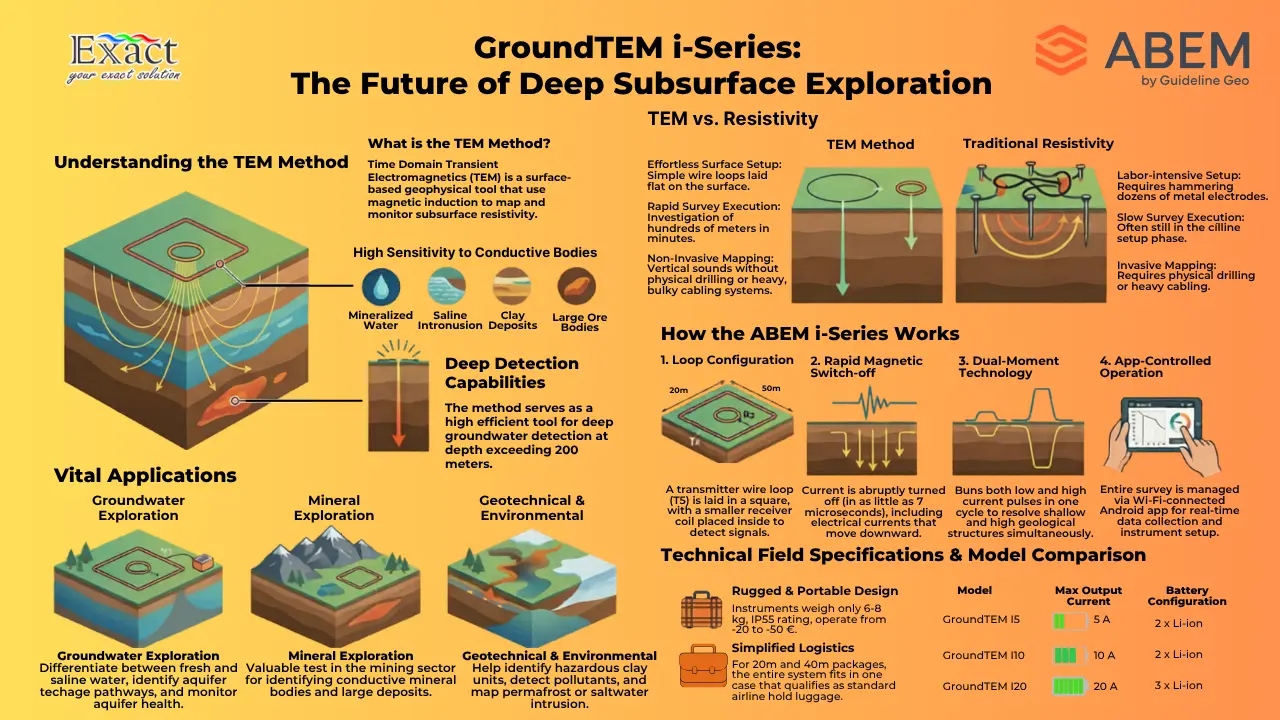
To put it simply, time domain transient electromagnetics (TEM) is a rapid, non-destructive geophysical tool used to search, map, and monitor the subsurface. Rather than relying on physical drilling or invasive testing right away, TEM allows us to obtain vertical resistivity soundings from the surface.
The TEM method responds exceptionally well to conductive bodies hidden beneath the earth. Because fluids, specifically mineralized or saline water, and certain minerals conduct electricity easily, TEM is an ideal choice for targeting groundwater, clay deposits, saline intrusion, and large ore bodies. It serves as an incredibly fast tool to investigate depths of hundreds of meters in just a matter of minutes. This capability easily positions it as an effective deep groundwater detection tool >200 meters.
2. The Accuracy Analysis: Differences Between TEM and Traditional Resistivity
When we need to map resistivity variations to locate groundwater, monitor aquifer health, or identify geological deposits, the way we gather our data heavily impacts our project timeline and accuracy.
Traditional electrical resistivity testing generally requires our field crews to hammer dozens of heavy metal electrodes into the ground in long, straight lines. These electrodes must be connected by heavy, bulky cables. In dense Indonesian forests or rocky terrains, this traditional setup can take hours and requires significant manual labor.
The TEM method offers a completely different approach. Instead of injecting current directly into the ground through metal stakes, TEM utilizes wire loops laid out flat on the surface. By using magnetic induction, TEM can penetrate much deeper into the ground in a fraction of the time. In fact, a TEM survey can finish investigating hundreds of meters deep while other traditional survey methods would still be busy setting up their cables. For deep aquifer exploration where speed and data accuracy are critical, TEM clearly outpaces older methods.
3. Unveiling the Technology: How the ABEM GroundTEM i-Series Works
When we apply the TEM method, the quality of our data depends on our equipment. The ABEM GroundTEM range—which includes the i5, i10, and i20 models—represents an affordable, user-friendly, and powerful entry-level system that complements the broader ABEM WalkTEM family.

Here is exactly how the ABEM i-Series works to map the subsurface:
- Setting Up the Loops: We lay out a transmitter wire loop (Tx) in a square shape on the ground. Depending on our depth requirements, we can choose loop options of 20 × 20 m, 40 × 40 m, or 80 × 80 m. We then place a smaller receiver coil, typically 3 × 3 m or 5 × 5 m, inside or near the main loop.
- Creating the Magnetic Field: The instrument sends a strong electrical current flowing through the main transmitter loop, which creates a primary magnetic field.
- Inducing Ground Currents: The system abruptly turns the transmitter off. The switch-off happens incredibly fast, in just 7 microseconds for the low moment and 13 microseconds for the high moment. This collapsing magnetic field creates electrical currents moving downward into the ground.
- Detecting the Signal: As these ground currents move, they create a secondary magnetic field. Our receiver loop detects this secondary field, allowing the system to record the data and calculate the resistivity of the earth below.
- Dual-Moment Technology: The ABEM GroundTEM instruments are dual-moment. This means they run both low and high current pulses through the transmitter loop during a single measurement cycle. This automatically combines the data, giving us excellent resolution for both shallow near-surface structures and deep geological responses.
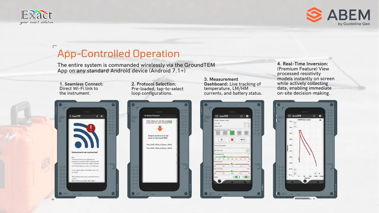
- App-Controlled Operation: The whole setup is controlled via the GroundTEM App on an Android device (Android 7.1 and above) using a Wi-Fi connection. We can easily handle instrument set-up and data collection directly from a smartphone or tablet.
4. Multipurpose Solutions: Applied for Mineral, Groundwater, and Geotechnical Exploration
Because of its high sensitivity to conductive materials, we can apply the TEM method across several vital industries and exploration projects in Indonesia:
Groundwater Exploration TEM is widely recognized as a premier method for hydrogeological studies. It helps us differentiate between fresh, brackish, and saline water deposits. We can use it to monitor the drawdown and recharge of an aquifer, identify recharge pathways, and estimate the physical extents of underground water reserves by building up profiles or grids of soundings. It acts as our primary deep groundwater detection tool >200 meters.
Mineral Exploration Since TEM responds very well to conductive mineral bodies, it is a highly valuable tool in the mining sector. With multi-component measurements and the ability to determine chargeability from Induced Polarization (IP) effects in the TEM data, the ABEM instruments serve as a powerful tool in the search for new mineral deposits and large ore bodies.
Environmental and Geotechnical Surveys For our environmental and geotechnical engineers, TEM provides a fast way to survey a wide range of applications. We can use it to identify potentially hazardous clay units within a geological sequence, detect potential pollutants, monitor saltwater intrusion, and even map dynamic features like permafrost thickness.
5. Designed for the Field: Why We Recommend ABEM for Indonesian Terrain
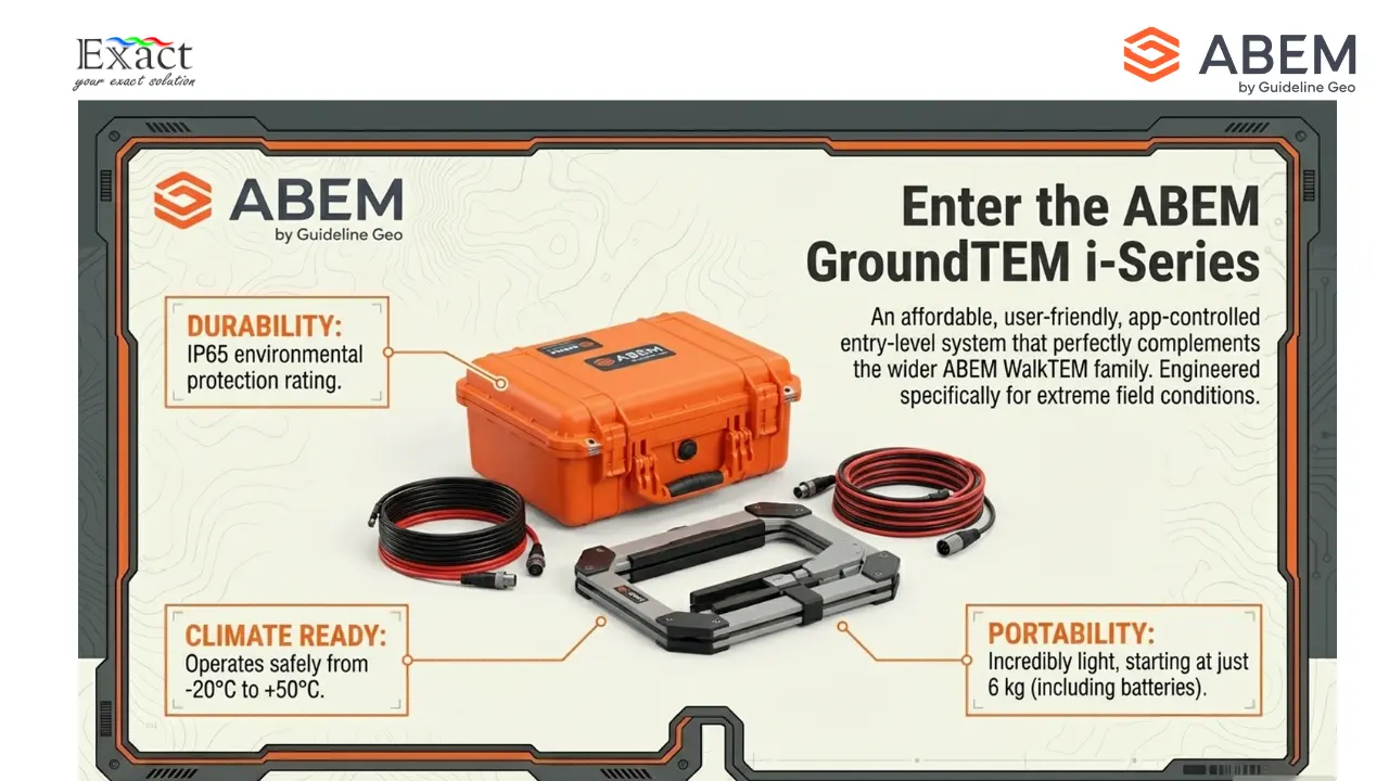
Working in Indonesia means dealing with extreme heat, high humidity, and remote locations. The ABEM GroundTEM i-Series is perfectly suited for these challenges.
The instrument features an IP65 environmental protection rating and operates safely in temperatures ranging from -20 to +50 °C. The unit is incredibly portable, weighing only 6 kg for the i5 and i10 models, and 8 kg for the i20 model, including its removable Li-ion batteries.
Shipping and logistics are also simplified. The GroundTEM i-Series includes heavy-duty shipping cases. For the 20 m and 40 m transmitter packages, everything fits seamlessly into one single box, including the instrument, transmitter loop, receiver coil, and battery charger. If we remove the batteries and charger, the main case can even fly as standard hold luggage on commercial airlines, making remote island deployments much easier.
Finally, the GroundTEM i-Series offers an optional premium “Real-time inversion” feature. This allows our teams to view processed resistivity models instantly on the screen while still actively collecting TEM data in the field, enabling immediate decision-making.
Partner With Us
To successfully implement the Transient Electromagnetic Method in Indonesia, having the right technology partner is essential. As a trusted Distributor ABEM GroundTEM, we are ready to support your geological, hydrogeological, and geotechnical projects.
For technical consultations, equipment inquiries, or to learn more about deploying a highly accurate deep groundwater detection tool >200 meters for your next project, please reach out to our team:
Exact Global Teknologi
- Website: ww.exactglobal.co.id
- Email Marketing: marketing@exactglobal.co.id
- WhatsApp: +62 812-9252-3900
Frequently Asked Questions (FAQ)
-
What exactly is the Transient Electromagnetic (TEM) Method?
TEM is a rapid, non-destructive geophysical technique used to obtain vertical resistivity soundings. It uses wire loops on the surface to induce electrical currents in the ground, allowing us to map subsurface structures, aquifers, and conductive mineral deposits.
-
What are the main differences between TEM and traditional electrical resistivity?
Traditional resistivity requires us to hammer metal electrodes into the ground and run long, heavy cables, which is slow and physically demanding. TEM utilizes simple wire loops laid flat on the surface and can investigate depths of hundreds of meters in just minutes, making it a much faster and more practical solution.
-
Is the ABEM GroundTEM effective as a deep groundwater detection tool >200 meters?
Yes, it is highly effective. The method responds strongly to conductive bodies like water. By utilizing the dual-moment system (which sends both low and high current pulses) and selecting higher power models like the GroundTEM i20, we can achieve very deep soundings while maintaining high-resolution data near the surface.
-
How difficult is it to operate the ABEM GroundTEM i-Series?
The ABEM GroundTEM is designed to be very user-friendly. The entire system is controlled via the GroundTEM App on a standard Android device (Android 7.1 or above). The app connects to the instrument over Wi-Fi, guiding us through instrument set-up, data collection, and even providing real-time inversion to see immediate results in the field.
-
Can this equipment be easily transported to remote areas in Indonesia?
Absolutely. The main instrument weighs only 6 to 8 kg depending on the model (including batteries) and is housed in a rugged IP65 case. For the 20 m and 40 m loop packages, the entire kit fits into a single shipping case that can fly as standard hold luggage on commercial flights when the batteries are removed, making island-hopping and remote access very straightforward.


