When we plan for Mineral Deposit Exploration 2026, our field teams need equipment that delivers fast, accurate, and deep subsurface data. We cannot afford to waste hours hammering electrodes into rocky terrain or dragging heavy cables through dense forests. We need a system that allows us to work quickly and gather high-resolution data on the spot.
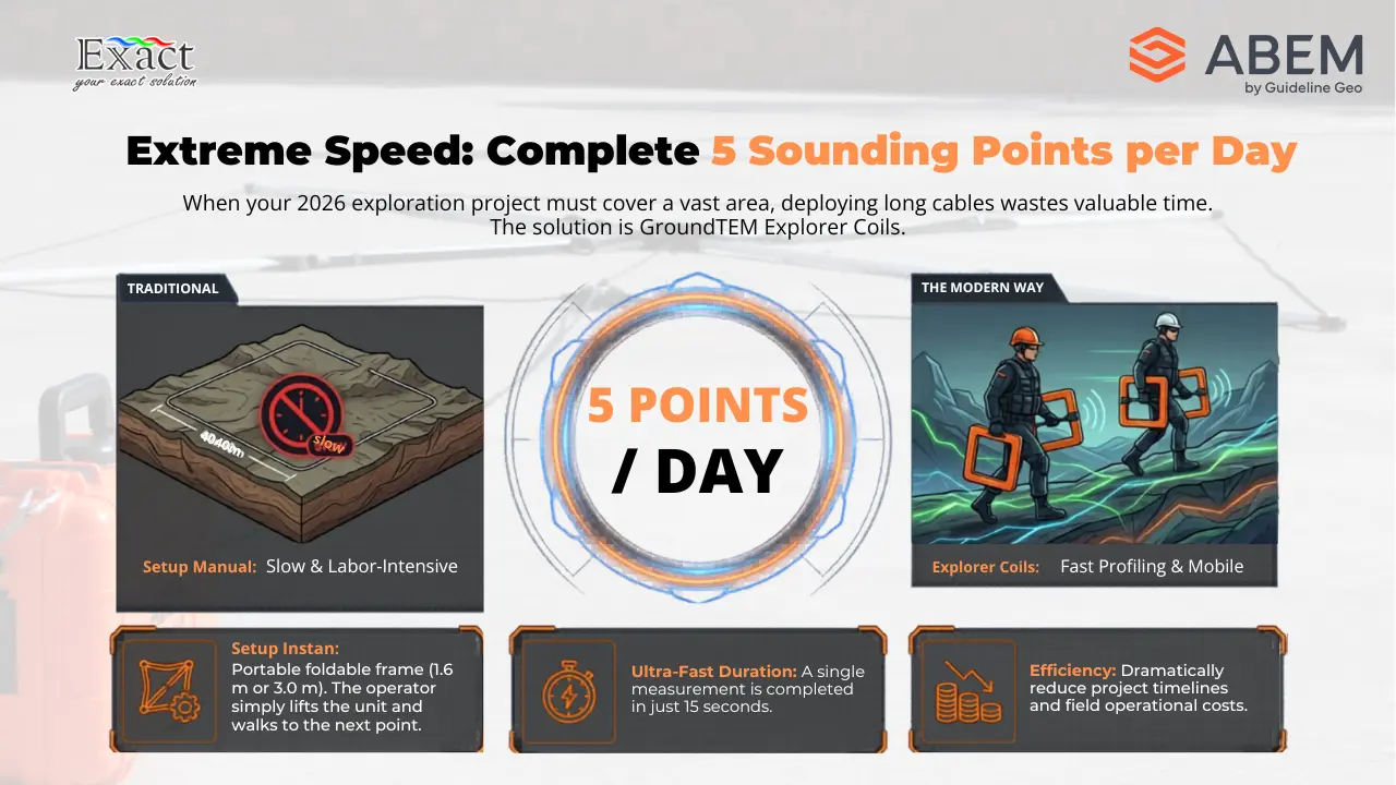
As the official distributor of the ABEM GroundTEM i-Series in Indonesia, we understand the exact needs of geophysicists and exploration companies today. The Transient Electromagnetic (TEM) method is the fastest survey tool for mapping groundwater and mineral deposits. With the ABEM GroundTEM i-Series, our teams can easily finish 5 sounding points per day, drastically cutting down project timelines and operational costs.
In this detailed technical guide, we will examine the core specifications of the ABEM GroundTEM i-Series and explain why it is our top recommendation for Groundwater and Mineral Deposit Exploration 2026.
The Core of Mineral Deposit Exploration 2026: Understanding the TEM Method
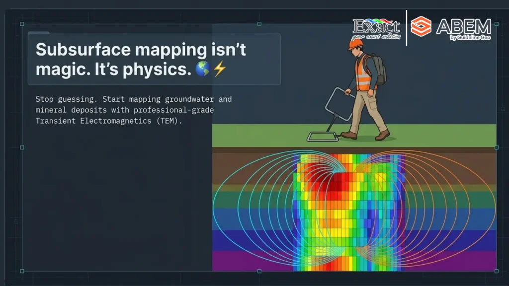
Time domain transient electromagnetics (TEM) is a rapid, non-destructive tool we use for the search, mapping, and monitoring of mineral deposits, groundwater, and environmental changes. Instead of injecting electricity directly into the ground through metal stakes, we use a wire loop laid flat on the surface. We send a current through this transmitter loop, creating a primary magnetic field.
When we turn the transmitter off, the collapsing magnetic field creates electrical currents in the ground. These moving ground currents then create a secondary magnetic field, which we record using a receiver coil. The TEM method responds exceptionally well to conductive mineral bodies. By using multi-component measurements, we have the ability to determine chargeability from Induced Polarization (IP) effects in the TEM data. This makes the TEM method a powerful tool in our search for new mineral deposits. We can investigate depths of hundreds of meters in just a few minutes, allowing us to finish our work while teams using other survey methods would still be setting up their cables.
Dual-Moment Technology for Shallow and Deep Precision
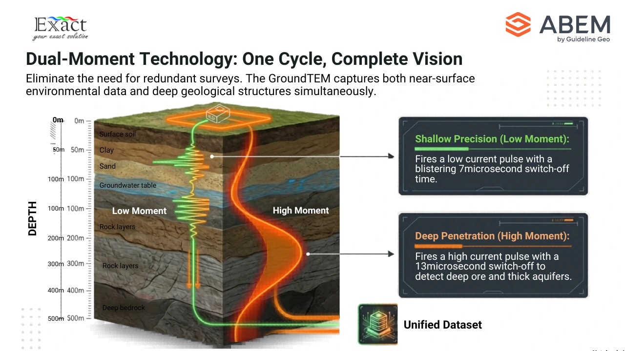
To get a complete picture of the earth below us, we need data from both the shallow near-surface layers and the deep geological structures. All ABEM GroundTEM instruments use dual-moment technology.
This means the instrument runs both a low current pulse and a high current pulse through the transmitter loop in a single measurement cycle. The switch-off time for the low moment is incredibly fast, measuring just 7 microseconds. This fast switch-off gives us excellent data resolution for shallow layers. The switch-off time for the high moment is 13 microseconds, which pushes the signal much deeper into the earth. The system automatically combines all these low and high measurements into a single dataset for processing. We do not have to run two separate surveys to get shallow and deep data; the instrument handles it all at once.
Transmitter Output Options: i5, i10, and i20 Models Explained
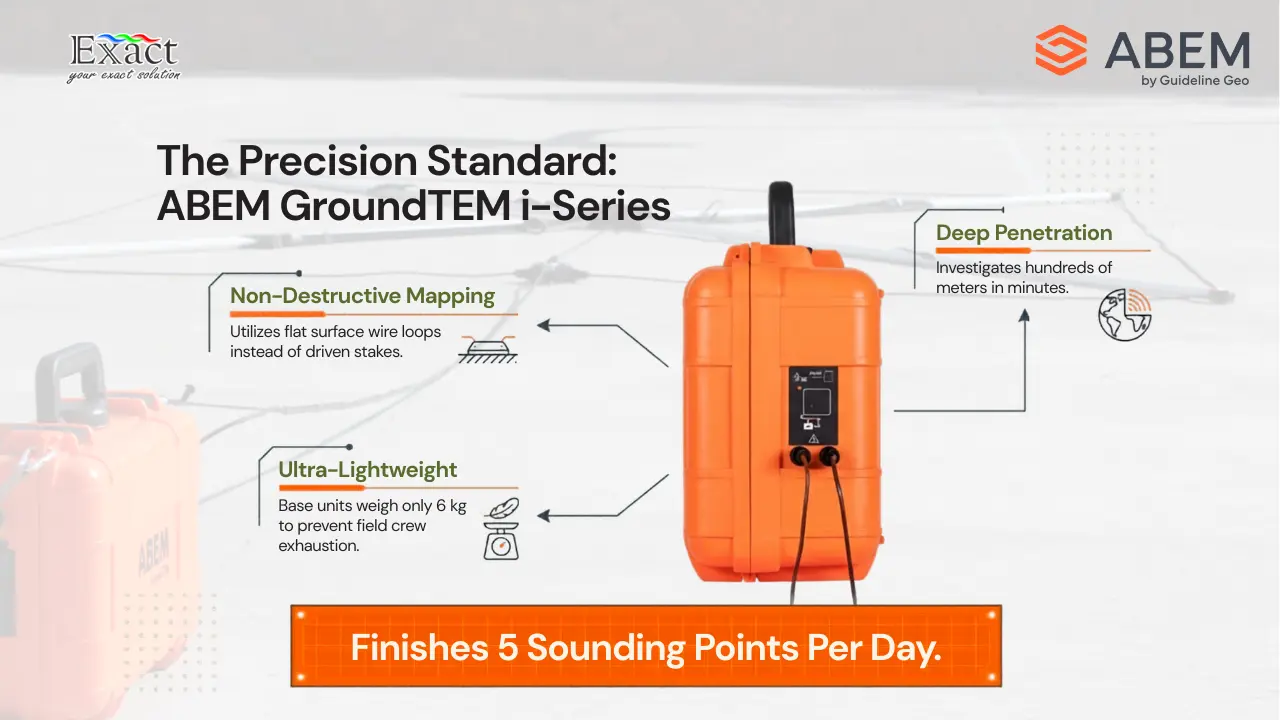
Different exploration projects require different depth penetrations. The depth we can reach depends on the maximum output current of our transmitter. The ABEM GroundTEM i-Series is available in three different models to match our power needs.
- GroundTEM i5: This is our entry-level system. It provides a 1 Ampere output on the low moment and a 5 Ampere maximum output on the high moment. It is highly capable for standard environmental and groundwater surveys.
- GroundTEM i10: This model offers the exact same size and weight as the i5, but unlocks more power. It outputs 1 Ampere on the low moment and 10 Amperes on the high moment. This gives us deeper measurement capabilities without sacrificing portability, making it a great compromise between power and weight.
- GroundTEM i20: For deeper Mineral Deposit Exploration 2026, we rely on the i20. It provides 1 Ampere on the low moment and a massive 20 Amperes on the high moment. This higher current sends a stronger magnetic field into the earth, allowing us to detect deep ore bodies and thick aquifers.
Loop Configurations for Varying Exploration Depths
The size of the wire loop we place on the ground dictates how deep we can see and the volume of earth we measure. The ABEM GroundTEM i-Series offers several transmitter (Tx) loop and receiver (Rx) coil options.
For the main transmitter loops, we have three standard square options:
- 20 × 20 meters: We use a 2.5 mm² wire with 1 turn.
- 40 × 40 meters: We use a 4.0 mm² wire with 1 turn.
- 80 × 80 meters: We use a thicker 6.0 mm² wire with 1 turn.
For the receiver coils, we place these inside or near the main transmitter loop. We have two options depending on the transmitter loop size:
- 3 × 3 meters: This is a 4-turn coil with a 200 kHz bandwidth. We use this standard coil with the 20m and 40m transmitter loops.
- 5 × 5 meters: This is a 4-turn coil with a 100 kHz bandwidth. We use this larger receiver coil specifically when we deploy the massive 80 × 80 meter transmitter loop.
When setting up the 20m or 40m loops, we use double markers to identify the corner where the cable reel and pre-amp box connect to the main instrument.
GroundTEM Explorer Coils: The Secret to Rapid Profiling
When our Mineral Deposit Exploration 2026 projects require us to cover vast areas quickly, laying out individual wire loops takes too much time. For rapid profiling, we use the GroundTEM Explorer Coils.
The Explorer Coils use a collapsible, poled frame with ergonomic handles, carry straps, and a strain-relief cord. This allows two operators to simply pick up the rigid frames and walk to the next point. We maintain a 10-meter separation between the transmitter and receiver coils during operation. We have two size configurations:
- 1.6 m Explorer Coils: This setup features a 1.65 × 1.65 m, 2-turn transmitter coil and a 1.65 × 1.65 m, 4-turn receiver coil. The total weight of this carrier solution is roughly 9 kg. We use this for a depth range of 50 to 100 meters.
- 3.0 m Explorer Coils: This setup features a 3.0 × 3.0 m, 2-turn transmitter coil and a 3.0 × 3.0 m, 4-turn receiver coil. The total weight is roughly 15 kg. We use this for a deeper depth range of 75 to 150 meters.
With the Explorer Coils, a single measurement duration starts from just 15 seconds. This is how we achieve incredible speed in the field.
Rugged Environmental Specifications for Indonesian Terrain
We know that working in Indonesia means facing extreme heat, high humidity, dirt, and heavy rain. The equipment we use for Mineral Deposit Exploration 2026 must survive these harsh conditions.
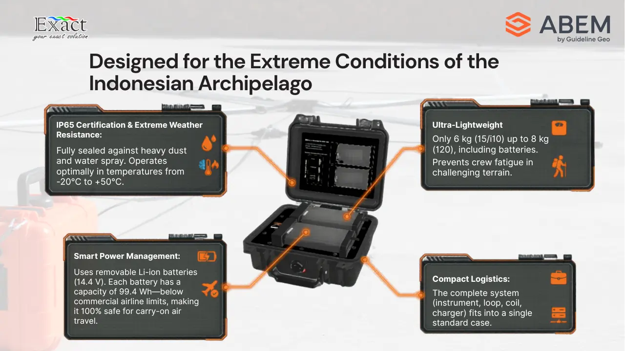
The ABEM GroundTEM i-Series features an IP65 environmental rating. This means the main instrument case is completely sealed against dust and can withstand low-pressure water jets from any direction. Furthermore, we can operate the system in extreme temperatures ranging from -20 °C to +50 °C.
Despite this heavy-duty protection, the instrument is very light. The GroundTEM i5 and i10 models weigh only 6 kg, including their batteries. The higher-power GroundTEM i20 model weighs just 8 kg, including its batteries. This low weight prevents our field crews from getting exhausted during long survey days.
Smart Power Management for Remote Fieldwork
Finding a reliable power source in remote Indonesian forests or distant islands is always a challenge. The ABEM GroundTEM i-Series manages onboard power efficiently.
Both the transmitter and receiver run on removable Lithium-ion batteries. The i5 and i10 models use two removable batteries, while the high-power i20 model uses three removable batteries. Each battery operates at 14.4 Volts, 6.8 Amp-hours, and holds 99.4 Watt-hours of energy.
Because the capacity of each battery is exactly 99.4 Wh, they sit just under the 100 Wh limit set by most commercial airlines. This makes it much easier for our teams to transport the batteries on flights when moving between project sites.
Seamless Wireless Control via the GroundTEM Android App
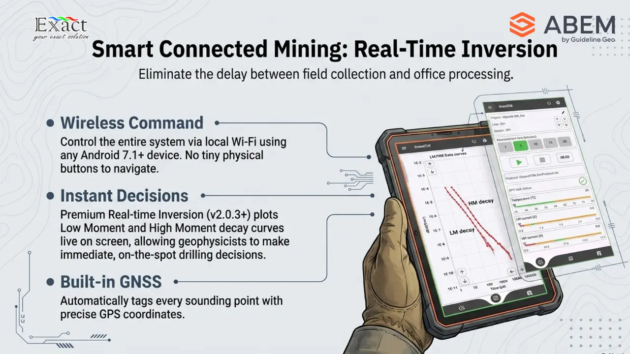
We do not have to navigate complicated internal menus or use tiny buttons on the instrument panel. We control the entire ABEM GroundTEM i-Series wirelessly using the GroundTEM App.
We can install the app on any standard Android device running Android 7.1 or above. The app connects to the main instrument box over a local Wi-Fi network. The user interface is highly intuitive. On the main screen, we can define the project name, set the line and station numbers, and choose our measurement time (options include 2, 5, 10, 15, or 20 minutes). We can also select the specific protocol we want to run, such as a 20x20m loop protocol at 50Hz.
The app displays real-time system health, including GPS lock status, internal temperature, low moment (LM) current, high moment (HM) current, and the battery levels for both the transmitter and receiver. We control instrument set-up and data collection entirely from our smartphone or tablet.
Real-Time Inversion: Making Drilling Decisions on the Spot
In the past, we had to collect data in the field, return to the office, and spend hours processing the files before we knew what was underground. For Mineral Deposit Exploration 2026, we cannot afford to wait.
The GroundTEM i-Series offers a premium license feature called “Real-time inversion”. If we run version 2.0.3 or higher of the GroundTEM i-Series App, we can view processed resistivity models instantly on our screen while we are still collecting TEM data in the field. The app plots the Low Moment and High Moment data curves (dB/dt over time) right on the display. By seeing the resistivity section immediately, our geophysicists can make fast, accurate decisions about where to drill or where to move the next survey point.
Built-in Positioning and Remote Diagnostics
Knowing the exact location of our mineral deposits is critical. The ABEM GroundTEM i-Series includes an onboard GNSS (Global Navigation Satellite System). This means every sounding point we take automatically records precise GPS coordinates, keeping our survey maps accurate without needing secondary handheld GPS units.
Additionally, the system supports remote upgrades and diagnostics via the internet. If we experience a technical issue or need a firmware update in a remote camp, we can connect the system to the internet. The factory technicians can run diagnostics remotely, minimizing our downtime and keeping our exploration projects on schedule.
Shipping and Logistics: Fits in Standard Hold Luggage
Transporting heavy geophysical gear across Indonesia’s islands can be a logistical nightmare. The ABEM GroundTEM i-Series solves this by packing everything into heavy-duty, compact shipping cases.
For the standard 20 m and 40 m transmitter packages, everything fits into one single shipping box. This includes the main instrument, the transmitter loop, the receiver coil, and the battery charger. If we remove the batteries and the charger, this main case can actually fly as standard hold luggage on commercial airlines.
If we choose the 80 m transmitter loop or the rigid Explorer Coils, the system ships in two cases. The Explorer Coil case measures 120 × 40 × 16.8 cm. The main instrument large case measures 80 × 60 × 43.3 cm. These dimensions are highly manageable for pickup trucks, small boats, and standard transport options across the archipelago.
Partnering with PT. Exact Global Teknologi
To successfully deploy the fastest groundwater and mineral survey tool in Indonesia, you need a partner who understands the technology and the terrain. As the official distributor for the ABEM GroundTEM i-Series, we provide full support, technical training, and warranty services for your equipment.
When you prepare for Mineral Deposit Exploration 2026, our team will ensure your operators know exactly how to lay the loops, use the Android app, and interpret the real-time inversion data.
For equipment inquiries, technical consultations, or to request a quote, please contact us directly:
- Website: ww.exactglobal.co.id
- Email Marketing: marketing@exactglobal.co.id
- WhatsApp: +62 812-9252-3900
Frequently Asked Questions (FAQ)
How fast is the ABEM GroundTEM i-Series for mineral exploration?
The system is incredibly fast because it uses wire loops laid on the surface rather than hammered electrodes. A standard deep sounding takes only a few minutes. If we use the GroundTEM Explorer Coils, a single measurement takes as little as 15 seconds. This speed allows our teams to easily finish 5 points a day, even in tough terrain.
What is the difference between the i5, i10, and i20 models?
The main difference is the transmitter output power. The i5 outputs a maximum of 5 Amperes, the i10 outputs 10 Amperes, and the i20 outputs 20 Amperes. Higher output current pushes the magnetic field deeper into the earth, allowing us to detect deeper aquifers and mineral deposits.
What is dual-moment technology and why do we need it?
Dual-moment technology means the instrument sends both a low-current pulse and a high-current pulse in one cycle. The low pulse switches off in 7 microseconds to capture shallow data, while the high pulse switches off in 13 microseconds to capture deep data. The system automatically combines these to give us a complete picture of the subsurface.
Do I need a specialized computer to control the GroundTEM?
No. The entire system is controlled via the GroundTEM App, which runs on any standard Android device with Android 7.1 or above. The tablet or smartphone connects to the instrument via Wi-Fi, allowing us to set up the survey and view data wirelessly.
Can I see the underground results while I am still in the field?
Yes. By using the premium “Real-time inversion” license on the GroundTEM App (v2.0.3 or higher), we can view processed resistivity models instantly on our screen while we are actively collecting data. This helps us make immediate drilling decisions without waiting to process data in the office.