When we plan a major project that requires understanding the earth beneath our feet, the success of our work depends entirely on the quality of the data we collect. Whether we are searching for clean groundwater, tracking underground pollution, designing safe foundations for a dam, or exploring for valuable minerals, we need a clear and accurate picture of the subsurface. This is why finding the right team and the best equipment is absolutely critical.
If you are currently evaluating different service providers, you might be wondering how to separate the average from the exceptional. To help you make the best decision, we have put together our top Tips for Choosing the Right Geoelectrical Equipment and services. In this guide, we will explore exactly what makes a professional service stand out, and we will explain why we firmly believe the ABEM Terrameter LS 2 is the premier, field-proven instrument for the job.
Here are the essential tips we recommend you follow when choosing a professional geoelectrical service.
Demand Uncompromised Data Quality and Accuracy
The most important tip we can offer is to ensure that the service provider uses equipment capable of delivering high-resolution, reliable data. Not all geoelectrical tools are created equal. Many older or lower-cost systems use shared circuitry or a single measuring range, which can lead to interference and weak signals.
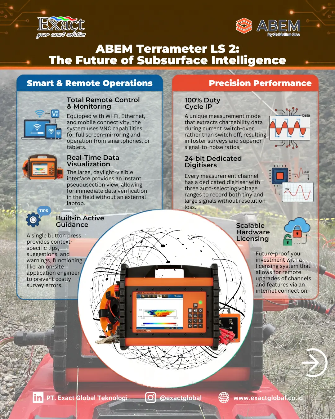
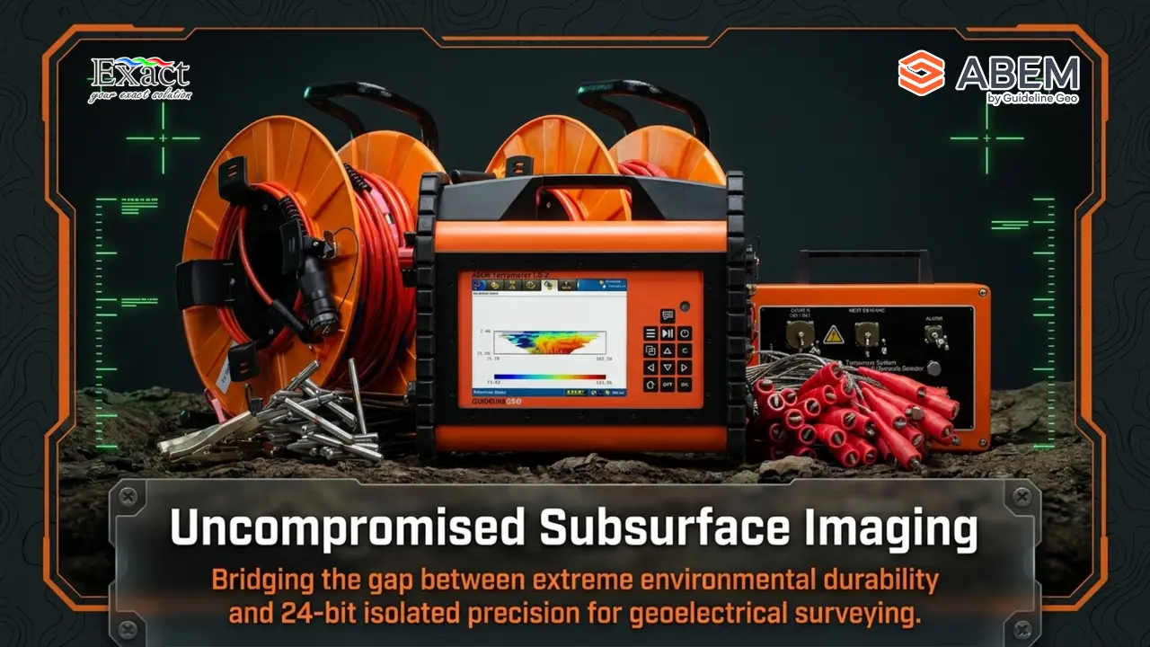
When we use the ABEM Terrameter LS 2, we benefit from a system that is engineered for outstanding data quality. It features completely isolated measurement channels, meaning each channel operates independently with its own 24-bit digitizer. This electrical isolation prevents strong signals from interfering with weaker, more subtle responses on nearby channels. Furthermore, the instrument automatically selects the best of three different voltage ranges, acting much like a zoom lens on a camera to capture both massive and tiny signals without losing any resolution.
Additionally, the Terrameter LS 2 uses constant current injections. This means the input signal remains fixed, which leads to a far more accurate assessment of the ground’s true resistivity and Induced Polarization (IP). When you hire a service using this equipment, you are guaranteeing that your data is as sharp and precise as modern technology allows.
Look for Advanced Surveying Capabilities (Like 100% Duty Cycle IP)
When we evaluate a geoelectrical service, we must look at how efficiently and deeply they can read the ground. Measuring electrical resistivity alone is often not enough. For example, fresh groundwater and underground clay often show very similar resistivity values. To tell them apart, we need to collect Induced Polarization (IP) data, which measures how the ground holds an electrical charge.
Traditionally, collecting IP data takes a long time, making it an expensive and slow process. However, the ABEM Terrameter LS 2 features a revolutionary 100% Duty Cycle IP mode. Instead of waiting for the current to switch off to measure the IP effect, this advanced mode extracts the IP data during the current switch-over period. Because it does not take any extra time, we can collect IP as a routine secondary dataset rather than an occasional special survey. This gives us a larger measurable effect, faster measurements, and significantly better quality data.
The system also includes full-waveform recording, which captures the entire electrical signal. This is incredibly useful for advanced diagnostics and detecting subtle variations associated with difficult targets, such as deeply buried pollutants.
Prioritize Rugged, Field-Ready Equipment
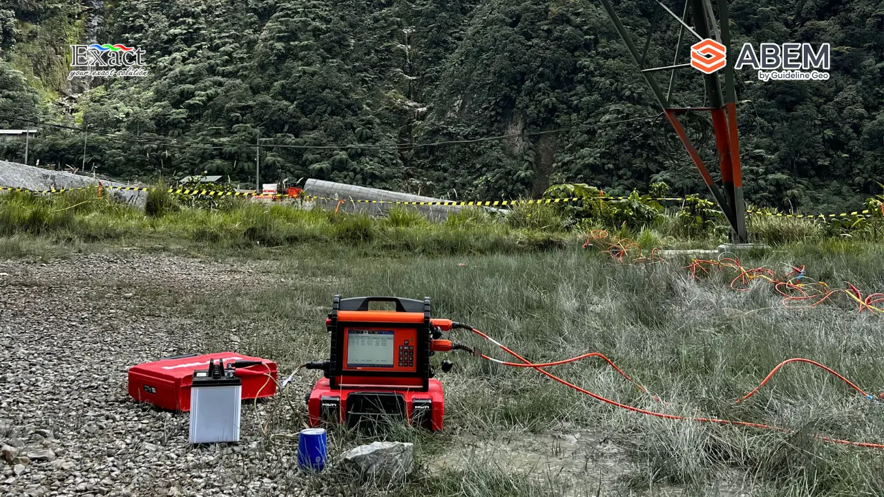
Indonesia presents some of the most challenging field conditions in the world. From intense heat to heavy tropical rains, the equipment used by your geoelectrical service must be able to survive harsh environments without breaking down and causing project delays.
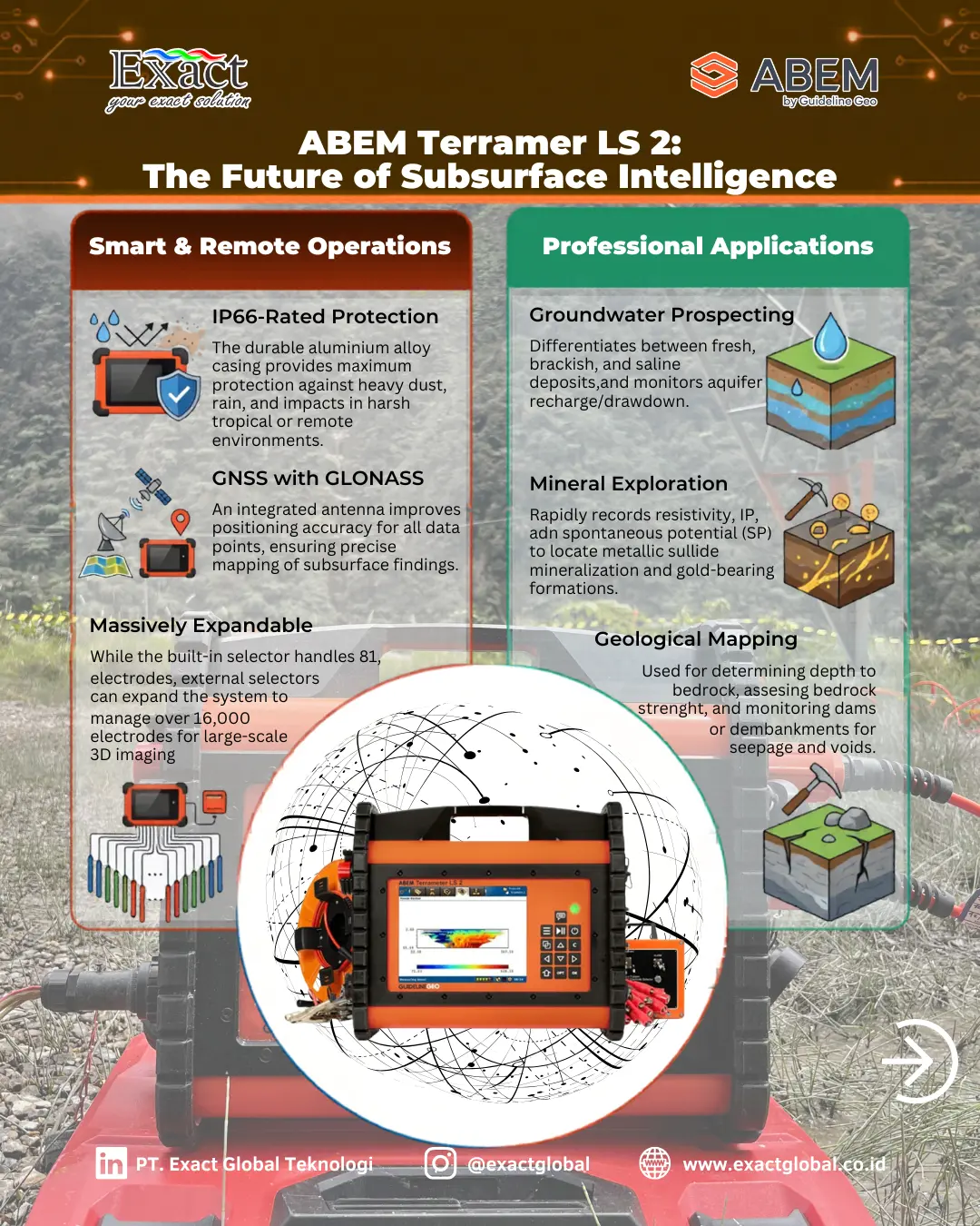
When we choose the ABEM Terrameter LS 2, we are choosing a highly durable, self-contained system. Unlike competitor instruments that rely on uncertified, weatherproof fiberglass, the Terrameter LS 2 is built with a rugged, IP66-rated aluminum alloy casing. This robust housing protects the vital internal electronics from dust and high-pressure water jets, ensuring that we can achieve reliable, day-to-day operation no matter where the site is located. It also handles a broader range of operating temperatures, meaning our surveys will not be halted by extreme weather conditions.
Require Smart Technology for Remote Control & Monitoring
Modern geoelectrical surveys should not be limited by physical presence. A top-tier service provider utilizes smart technology to monitor long-term projects remotely.
The ABEM Terrameter LS 2 excels in Remote Control & Monitoring. It is equipped with built-in Wi-Fi, Ethernet, and mobile connectivity. Through its advanced VNC Capabilities, we can easily establish screen mirroring and control the instrument from almost any remote device, including PCs, smartphones, or tablets. By connecting to the instrument’s IP address and entering a secure password, we can view the desktop and operate the system as if we were standing right in front of it.
This connectivity is perfect for autonomous monitoring programs, such as keeping a continuous watch on a dam for seepage or tracking a pollution plume over several months. The built-in scheduling tools allow the instrument to wake up, run a test, and send the data without anyone needing to travel to the site.
Furthermore, this setup enables instant Remote Troubleshooting. If a complex problem arises in the field, we do not have to pack up the equipment and ship it back to a workshop. Instead, technical support engineers can access the instrument securely over a Virtual Private Network (VPN) via the internet, run diagnostics, and update software directly on the spot. This smart technology keeps downtime to an absolute minimum.
Check for Built-In Quality Control and Active Guidance
Human error is one of the biggest risks in any field survey. Setting up thousands of meters of cables and electrodes can be complicated. We recommend choosing a service that uses equipment designed to actively reduce these errors.
The ABEM Terrameter LS 2 stands completely on its own; it does not require an external laptop or fragile tablet to run. It features a large, daylight-visible graphical user interface that offers a real-time pseudosection view of the data. This means we can instantly see the subsurface image forming while we are still in the field, allowing us to verify data quality immediately.
Even better, the instrument features “Active Guidance”. With a single press of a button, the system detects the current menu or command and provides expert tips, suggestions, and warnings to help avoid costly mistakes. It is like having an experienced application engineer standing right by our side, ensuring that our deployment is accurate and successful every single time. The system also runs automated self-tests, relay tests, and cable tests onboard, guaranteeing that every component is fully functional before we even put electricity into the ground.
Ensure the System is Versatile Across All Applications
A truly professional geoelectrical team should be able to adapt to the specific needs of your project. We rely on the Terrameter LS 2 because there are virtually no engineering applications that it cannot handle.
The system supports multi-electrode survey configurations for 1D soundings, long 2D profiles, and complex 3D grids. It is incredibly versatile across different sectors:
- Groundwater Prospecting: We can easily locate aquifers, monitor groundwater recharge, and accurately differentiate between freshwater and conductive clay using the IP measurements.
- Geological and Geotechnical Mapping: We use it to determine the depth to solid bedrock, locate underground voids, map potential slip planes, and monitor infrastructure like dams and embankments for internal water seepage.
- Mineral Exploration: Because it can rapidly capture both resistivity and chargeability (IP) data, it is a highly efficient tool for locating metallic sulfide mineralizations and gold-bearing formations near the surface.
- Marine and Borehole Surveys: We can even deploy the cables across rivers to plan bridge foundations or drop them down boreholes to get high-resolution data deep underground.
With an internal switching matrix that can handle up to 81 electrodes natively—and the ability to connect external selectors for over 16,000 electrodes—the scale of the survey is virtually limitless.
Choose a Provider Backed by Exceptional After-Sales Service
The final, and perhaps most crucial, tip is to look beyond the hardware and evaluate the support network behind it. Even the best equipment in the world requires maintenance, expert advice, and occasionally, rapid replacement parts.
When operating in Indonesia, you want to ensure that your geoelectrical tools are supported locally by experts. This means seeking out the official ABEM Terrameter LS2 Distributor in Indonesia.
Exact Global Teknologi are not just a product supplier; we are a trusted distributor providing the highly reliable After-sales service that professionals demand. From professional instrument inspection to workflow maintenance and direct engineer support, we ensure that our equipment is always field-ready. When you choose a service backed by this level of professional distribution, you ensure that your project will never be left stranded.
When the success of your infrastructure, mining, or environmental project relies on understanding what lies beneath the surface, you cannot afford to guess. By following these tips—demanding uncompromised data quality, rugged durability, remote capabilities, and versatile workflows—you safeguard your investment.
We trust the ABEM Terrameter LS 2 because it brings all of these features together into one incredibly robust, intelligent package. From its unique 100% Duty Cycle IP to its advanced VNC remote control capabilities, it truly is the number one choice for professional geoelectrical surveys in Indonesia.
Frequently Asked Questions (FAQ)
What is the advantage of the ABEM Terrameter LS 2’s 100% Duty Cycle IP?
Traditional Induced Polarization (IP) measurements require extra time because the system must turn off the electrical current to measure the ground’s decaying charge. The 100% Duty Cycle mode extracts the IP data during the switch-over period of the current pulse, allowing us to gather crucial IP data at the exact same speed as a standard resistivity survey, drastically improving field efficiency and data quality.
How does the equipment handle harsh weather and field conditions?
The Terrameter LS 2 is built with a highly durable, IP66-rated aluminum alloy casing. This provides maximum protection against heavy dust, rain, and impacts, ensuring reliable operation even in the toughest tropical or remote environments.
Can the ABEM Terrameter LS 2 be monitored remotely?
Yes. The system has built-in Wi-Fi, Ethernet, and mobile connectivity. Utilizing its VNC Capabilities, an operator can mirror the instrument’s screen and control it in real-time from a computer or mobile device. This is incredibly useful for long-term, autonomous monitoring of dams or pollution sites.
What happens if there is a technical issue in the field?
Thanks to its advanced connectivity, the instrument supports Remote Troubleshooting. We can connect the Terrameter LS 2 to a standard internet network, allowing support engineers to securely log in via a Virtual Private Network (VPN). They can perform remote diagnostics, check electrode contacts, and update software without the unit ever leaving the job site.
Why is it important that the channels are “galvanically separated”?
Galvanic isolation means that every measurement channel operates on its own dedicated circuit with its own 24-bit digitizer. This stops strong electrical signals on one channel from bleeding over and corrupting the weak, delicate signals on another channel, leading to much more accurate and trustworthy subsurface models.
Who do I contact for equipment sales and reliable after-sales service in Indonesia?
For official distribution and top-tier after-sales support, you should contact the trusted ABEM Terrameter LS2 Distributor in Indonesia, PT. Exact Global Teknologi.
Contact PT. Exact Global Teknologi
Your Trusted Distributor for Smart Technology & Reliable Support
- Website: ww.exactglobal.co.id
- Email Marketing: marketing@exactglobal.co.id
- WhatsApp: +62 812-9252-3900