Let’s face a hard truth about urban infrastructure: paper lies. If we are managing a utility trenching project along Jakarta’s narrow sidewalks, we already know that the legacy as-built drawings in our hands are little more than rough estimates. Beneath that 1.5-meter stretch of concrete lies a chaotic, undocumented web of old water pipes, active fiber optic lines, and high-voltage cables.
As we work to modernize our city, the push for Integrated Utility Networks (Sarana Jaringan Utilitas Terpadu or SJUT) has become a major priority. We are moving hanging cables underground and fixing our pedestrian walkways. However, underneath these narrow sidewalks lies a chaotic, unmapped maze of old utilities.
Relying on guesswork or outdated maps to guide our excavators is essentially playing Russian roulette with our project’s budget. One wrong scoop can lead to a ruptured pipe, billions of Rupiah in fines, and a halted project. We can no longer afford to guess what lies beneath our feet. To safely and accurately map utilities on tight sidewalks, we must adopt 3D GPR in Indonesia.
Ground-penetrating radar (GPR) is a highly effective geophysical method that uses radio waves, typically between 30 and 3000 MHz, to non-destructively image the subsurface without requiring any excavation. Today, advanced 3D GPR technology provides the exact solutions we need to handle Jakarta’s complex urban environment.
Here are the top 10 reasons why our sidewalk and SJUT projects must stop guessing and start using true 3D Ground Penetrating Radar.
1. Paper As-Built Drawings Are Basically Fiction
When we look at utility maps from ten, twenty, or fifty years ago, we are looking at an ideal plan, not the current reality. Over the decades, Jakarta has seen countless overlapping infrastructure projects. A telecommunications company lays a cable. Five years later, the water company repairs a pipe and shifts that cable half a meter to the left. No one updates the master drawing. By the time our team arrives to dig a new trench for the SJUT project, the actual layout of the underground utilities looks nothing like the paper map.
If our operators trust the paper map and start digging, they are digging blind. This practice, known as blind trenching, is the leading cause of utility damage on construction sites. We have to map the site as it exists today, right now. Modern 3D mapping gives us an exact, centimeter-accurate picture of what is actually buried beneath our boots, completely eliminating our reliance on outdated historical data.
2. Traditional 2D GPR Fails on 1.5-Meter Sidewalks

In the past, we mostly used 2D GPR systems. It looks like a heavy lawnmower that a surveyor pushes in a straight line. A 2D GPR only sees straight down. These tools require operators to walk in multiple grid lines, trying to mentally piece together individual 2D slices of the ground. To create a 3D map using a 2D system, our surveyors have to push the machine back and forth in a tight, intersecting grid pattern (like a checkerboard).
On an open highway, this is fine. On a narrow, broken Jakarta sidewalk that is barely wide enough for two pedestrians, pushing a cart in a perfect intersecting grid is physically impossible. Because we cannot complete a proper grid on a tight sidewalk, the data comes back incomplete. We are left with gaps in our map, which means we still do not know exactly where the pipes are.
We need an array system. Advanced systems like MIRA (MALÅ Imaging Radar Array) provide a multichannel 3D GPR array solution. A true 3D GPR array fires multiple radar signals at the same time across a wide path. We just push it straight down the sidewalk once. No complex grid maneuvers are needed.
3. The Dangerous Threat of “Pseudo-3D” Blind Spots
There is a dangerous myth in our industry right now. Many contractors pay for “3D mapping services” and receive a 3D model, but they are actually getting “Pseudo-3D”. If a vendor uses a 2D GPR to scan a site with lines spaced 0.5 meters apart, the computer software uses an algorithm to connect the dots and draw a pipe where it thinks a pipe should be. This is called interpolation.
However, simple interpolation methods degrade quickly when the line spacing increases. Software guessing is highly risky. If a small fiber optic cable crosses the sidewalk at an odd angle right between our survey lines, the software might miss it entirely. Our map looks clean, but an invisible cable is waiting to be cut by our excavator.
By adopting true 3D GPR in Indonesia, we capture 100% of the data under the machine. The antennas are spaced just centimeters apart. There are no gaps. A dense, multichannel 3D GPR system collects information tightly across its width. The computer does not have to guess because the hardware captures everything in one pass, giving us a realistic and structurally consistent image of the underground.

4. Spotting Both Metal and Plastic Pipes is Mandatory
One of the biggest mapping challenges we face during SJUT construction is finding non-metallic utilities. Traditional cable locators only respond to metal, making them completely useless for finding PVC water pipes, fiber optic ducts, or concrete sewer lines. If we only map the metal, we are still digging blind.
Because 3D GPR relies on measuring the changes in the electrical properties of buried materials rather than just searching for metal, it solves this problem easily. By sending short pulses into the ground and recording the reflections from different materials, we can accurately locate and map both metallic and non-metallic utilities. By identifying all types of buried lines, we significantly reduce the risk of striking a hidden water main and support much safer excavation processes.
5. High-Density Urban Soil Requires Advanced Signal Tech
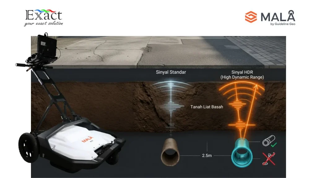
Jakarta’s ground conditions are notoriously difficult for radar equipment. The soil under Jakarta’s sidewalks is often a mix of wet clay, old concrete rubble, rebar from previous construction, and high groundwater. Wet clay is highly conductive; it absorbs standard radar signals like a sponge, leaving us with a blurry, unreadable screen.
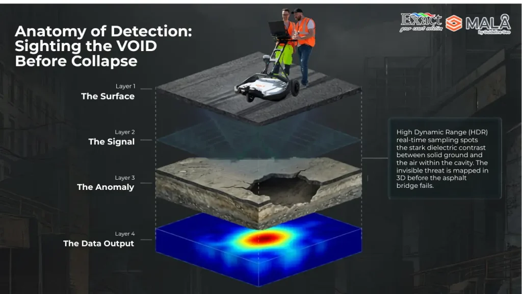
When the radar signal is absorbed by wet soil, we lose penetration depth. We might only see 50 centimeters down, completely missing the main gas line buried at 1.5 meters. We must use equipment built for tough environments, specifically systems featuring High Dynamic Range (HDR) technology. HDR cuts through the noise of urban soil, providing a crystal-clear signal that reaches deeper and gives our engineers a much sharper image of the pipes below, even in wet conditions.
6. Real-Time Visuals and Rapid Data Processing
In a heavily populated city, closing a sidewalk or road for surveying causes major disruptions. Traditional GPR surveys often require hours or days of complicated office processing before the map is ready. Delays in mapping lead to idle heavy equipment and idle workers. If we pause the project waiting for a report, our overhead costs skyrocket.
Modern 3D GPR software streamlines this entire workflow. Solutions like the MALÅ MIRA Controller offer an intuitive interface that seamlessly transfers project data to processing platforms like MALÅ Vision Desktop. This powerful setup delivers results in minutes rather than hours. As we push the cart down the sidewalk, the screen displays a top-down “time-slice” of the ground. It looks like an X-ray. Our site managers can look at the screen, see a pipe crossing the path, mark the concrete with spray paint, and direct the digging team on the exact same day.
7. Preventing Sinkholes and Road Collapses
SJUT projects involve a lot of trenching and drilling, which can sometimes destabilize the surrounding ground. Additionally, leaky old pipes that we haven’t found yet can wash away soil over time, creating hidden voids that eventually turn into dangerous sinkholes. 3D GPR does more than just find pipes; it evaluates the health of the ground itself. We can use these systems to assess roadbeds and infrastructure for voids and layer thickness. Early detection of sinkholes supports safer networks and long-term asset management.
8. Preventing Billion-Rupiah Utility Strikes
Hitting an underground pipe is a nightmare scenario that not only causes massive water leaks or power outages but also brings costly project delays. Striking a high-pressure water main or a major fiber optic trunk line causes immediate disaster. The utility owner will charge us for the repair, which can run into hundreds of millions of Rupiah. A broken water main washes away the soil, potentially collapsing the sidewalk or the adjacent road. Cutting an internet cable for an entire business district or causing a traffic jam makes our company look incompetent in the public eye. An investment in accurate 3D mapping is an insurance policy. Knowing exactly where the hazards are allows us to plan safe digging zones, completely avoiding the financial ruin of a utility strike.
9. Compact Footprints Mean Zero Pedestrian Disruption
A common concern with advanced mapping equipment is its size. Jakarta’s sidewalks are famously narrow, often blocked by trees, streetlights, or uneven curbs. While some advanced 3D GPR systems exist, they are often built for towing behind trucks on open highways—making them wide, heavy, and impossible to lift over a curb. If the machine does not fit on the sidewalk, we have to close the adjacent traffic lane to do our survey. Closing a lane in Jakarta requires permits, police coordination, and causes severe traffic jams.
Fortunately, modern manufacturers have designed equipment specifically for these tight spaces. We need the power of a 3D array packed into a small frame, and solutions like the MALÅ MIRA Compact are designed exactly for this. It is the size of a baby stroller but delivers the same high-resolution output as larger array systems. It features an effective swath coverage of 0.6 meters, easily fitting on tight sidewalks. One person can push it down a crowded sidewalk without blocking pedestrians and without closing a single lane of traffic. We no longer have to compromise on data quality just because the working area is narrow.
10. Scalable for Any Project Size
While narrow sidewalks require compact tools, our utility projects often extend into main roadways or large intersections where hand-pushing a cart would be too slow. The great advantage of modern 3D GPR families is their scalability. For everyday 3D mapping applications on wider streets, systems like the MALÅ MIRA HDR offer an effective one-pass swath coverage of 1.4 meters. For highly specialized survey applications, there are customizable solutions like the MALÅ MIRA Flex. Whether we are mapping a 1-meter wide sidewalk or a multi-lane avenue, we have the exact hardware configuration needed to do the job efficiently.
Stop Guessing, Start Seeing
The era of blind trenching and trusting old paper maps is over. The risks are simply too high. Jakarta’s infrastructure is advancing rapidly, and our subsurface mapping techniques must advance with it. Relying on old maps and single-line radars leaves our SJUT projects vulnerable to dangerous utility strikes, costly project delays, and damaged infrastructure.
For the safety of our teams, the profitability of our projects, and the integrity of Jakarta’s infrastructure, we have to adopt the right technology. By implementing true 3D mapping with compact, high-performance equipment, we take the blindfold off. We turn a risky guessing game into a precise, calculated engineering process. Implementing 3D GPR in Indonesia is the most effective way to ensure our city’s underground development is safe, fast, and fully understood. It is time to stop guessing and start mapping with certainty.
Frequently Asked Questions (FAQ)
What is 3D GPR?
Ground-penetrating radar (GPR) is a geophysical tool that uses short pulses of radio waves (between 30 and 3000 MHz) to non-destructively map the underground. A 3D GPR system uses a multichannel array of antennas to collect a dense, continuous volume of data in a single pass, creating a true three-dimensional image of buried objects.
Why is 3D GPR better than older 2D systems?
2D GPR provides a single vertical slice of the ground, showing data as curved lines (hyperbolas) that require expert interpretation. If the subsurface is complex, simple interpolation between these separate 2D lines can distort the structures and lead to missed utilities. In contrast, 3D GPR uses multiple antennas to scan a wide path all at once. This captures high-resolution data, providing a top-down, X-ray-like image (time-slice) that reveals complex subsurface geometries accurately and leaves no blind spots.
Can 3D GPR detect plastic pipes?
Yes. Unlike traditional electromagnetic cable locators that only detect metal, GPR detects changes in the physical and electrical properties of the ground. It can easily find PVC water pipes, concrete drainage lines, fiber optic bundles, and even empty underground voids (cavities).
How deep can the radar penetrate in Jakarta’s soil?
Penetration depth depends heavily on soil conductivity. In dry, sandy soil, GPR can reach several meters. In Jakarta’s wet, clay-heavy soil, penetration is reduced. However, by using systems with HDR technology, we can typically map utilities cleanly down to 1.5 to 2.5 meters, which covers the vast majority of SJUT targets.
Will 3D GPR equipment fit on Jakarta’s narrow sidewalks?
Absolutely. While some systems are large and mounted on vehicles, compact versions are available specifically for tight spaces. For example, the MIRA Compact system features an effective swath coverage of just 0.6 meters and is designed for hand-pushed surveys, making it ideal for narrow sidewalks.
Do we need to shut down the road to map a sidewalk?
No. If you use a portable system like the MIRA Compact, it is narrow enough to push along standard sidewalks without disrupting vehicle traffic or requiring expensive road closure permits.
How long does it take to process the mapping data?
Modern 3D GPR software is highly efficient. By utilizing fast software that runs entirely offline using local computer resources, the system can process large datasets and deliver results in minutes rather than hours.
Is the data ready to be used in CAD or GIS software?
Yes. Modern 3D GPR systems connect with high-precision GPS. The data collected is highly accurate and can be exported directly into AutoCAD, Google Earth, or your company’s GIS platform for permanent record-keeping.
Can 3D GPR detect sinkholes?
Yes. In addition to finding pipes, 3D GPR is highly effective at assessing roadbeds and soil layers. It can identify subsurface voids and layer thickness variations, allowing for the early detection of sinkholes before they cause a collapse.
Ready to Secure Your Next Project?
At PT. Exact Global Teknologi, we understand the heavy pressure contractors face on urban utility projects. We are dedicated to bringing the most advanced technological solutions to infrastructure and utility projects. We are the official provider of advanced mapping solutions, including the MALÅ MIRA Compact, designed specifically to solve the headaches of Jakarta’s narrow sidewalks.
Do not let outdated maps cost your company billions in fines. Protect your margins and your reputation. Get in touch with us today to schedule a consultation or request an on-site demo.
Exact Global Teknologi
- Website: www.exactglobal.co.id
- Email Marketing: marketing@exactglobal.co.id
- WhatsApp: +62 812-9252-3900