As leaders managing public infrastructure, we know that buying the wrong equipment drains our budgets and puts our road networks at risk. Whether we operate as C-Level executives, Heads of Public Works (Kadis PUPR), or Airport Maintenance Directors, we face the same daily problem. We invest heavy public funds into road inspection technology, only to watch fragile, moving-part laser scanners break down under daily operational stress. When our inspection tools sit in the repair shop, our roads and runways go unmonitored.
We must stop buying fragile scanners that cannot handle real-world conditions. Instead, we need to look strictly at the technical specifications of true solid-state equipment. When we evaluate the market for a Mobile mapping system products in Indonesia, the data points clearly to the XenoTrack system by XenomatiX.
Instead of vague promises, we base our purchasing decisions on hard numbers, precise product specifications, and actual performance data. Here are the detailed product sheet specifications that prove why XenoTrack is the only logical investment for our infrastructure inspection needs.
1. True Solid-State Hardware with Zero Moving Parts
Most traditional laser scanners spin or rotate to capture data. These moving parts are highly sensitive to the bumps and vibrations of normal driving, making them prone to mechanical failure. We eliminate this failure rate by using a true solid-state Lidar. Here are the physical specifications of the XenoTrack sensor unit:
- Operating Principle: True solid-state Lidar (no spinning mirrors or internal moving rotors).
- Protection Ingress: IP65 rating (fully protected against dust and low-pressure water jets from any direction).
- Operating Temperature: -10 °C to 50 °C (perfect for our hot, tropical climates).
- Storage Temperature: -20 °C to 70 °C.
- Humidity Tolerance: 10% to 90% non-condensing.
- Sensor Dimensions: 46.7 cm wide x 19.7 cm deep x 12 cm high.
- Sensor Weight: Only 2.6 kg (making it extremely easy for a single operator to lift and handle).
- Laser Classification: Class 1 (completely eye-safe for public environments).
2. Three Specialized Hardware Models for Different Budgets
We do not have to buy a one-size-fits-all product. XenoTrack offers three specific hardware configurations. We can choose the exact field of view (FOV) and accuracy level that matches our specific road or runway projects.
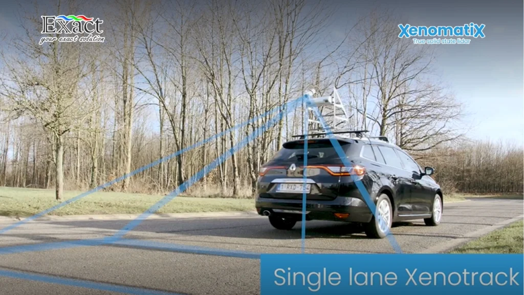
Single Lane Model Specifications:
- Lateral Field of View: 4 meters (covers one standard traffic lane).
- Longitudinal Field of View: 1.9 to 4.1 meters behind the vehicle.
- Smallest x-y Digital Twin Resolution: 5 mm by 5 mm.
- Height Accuracy of Road Surface: Less than 0.45 mm.
- Frame Rate: 40 Hz.
Dual Lane Model Specifications:
- Lateral Field of View: 7.5 meters (covers two lanes at the same time).
- Longitudinal Field of View: 2.9 to 7.5 meters behind the vehicle.
- Smallest x-y Digital Twin Resolution: 10 mm by 10 mm.
- Height Accuracy of Road Surface: Less than 0.65 mm.
- Frame Rate: 40 Hz.
Front View Model Specifications:
- Lateral Field of View: 7.5 meters.
- Longitudinal Field of View: 2.8 to 8.2 meters in front of the vehicle.
- Smallest x-y Digital Twin Resolution: 10 mm by 10 mm.
- Height Accuracy of Road Surface: Less than 0.95 mm.
- Frame Rate: 40 Hz.
For all three models, the system captures up to 1,120,000 measurement points per second, with a single laser accuracy of 0.23 mm (meeting the AASHTO R54-14 standard).
3. High-Performance Edge AI Computing (The X-Controller)

We do not want to upload massive amounts of raw data to expensive cloud servers just to find out where our potholes are. The XenoTrack system processes data locally using a highly powerful, dedicated in-vehicle computer called the X-Controller. Here is the technical sheet for the X-Controller:
- Processor (CPU): 6-core NVIDIA Carmel ARM v8.2 64-bit CPU (6 MB L2 + 4 MB L3 cache).
- Graphics Processor (GPU): 384-core NVIDIA Volta GPU with 48 Tensor Cores.
- Operating System: Linux RTOS.
- Memory: 8 to 11 GB 128-bit LPDDR4x.
- Storage Capacity: 2 TB SSD (Solid State Drive).
- Power Input: 6 to 28V DC (12V nominal), plugging easily into standard vehicle power.
- Surge Protection: Up to 40V/1ms transient power, limited to 8A.
- Power Consumption: 16W in operational mode.
- Dimensions: 10.6 cm x 14.0 cm x 5.5 cm.
- Weight: 760 grams.
This Edge-AI computer allows us to filter out shadows and visual noise instantly, running complex crack and pothole detection algorithms directly inside the vehicle as we drive.
4. 6D Road Scanning Data Output
When we inspect our infrastructure, simple camera images are not enough. We need measurable geometry. The system gives us “6D Road Scanning”, which combines 3D elevation data, 2D images, and surface intensity data, all linked to highly accurate GPS coordinates. Our storage and data bandwidth specifications include:

- Real-time Data Transmission: 25 MB/s via Ethernet or CAN interface.
- Camera System: External 12-Megapixel HD camera (XenoCam) taking images every 5 meters.
- Camera Data Size: 36.5 MB per raw image, or 2.5 MB per JPG image (totaling about 500 MB per kilometer driven).
- Lidar 3D Data Size: CSV format takes 640 MB per kilometer. LAS format takes 1.5 GB per kilometer. LAZ format takes 96 MB per kilometer. CRG format takes 150 MB per kilometer.
- Intensity Map Data: PGM format takes 78 MB per kilometer.
This means we have total flexibility. If we want raw, heavy point clouds (LAS), we have them. If we want highly compressed files (LAZ or CSV) to quickly share with our contractors over email, we can do that too.
5. Automated Crack Detection Module (SW-DRP-1016)
Human inspectors cannot physically measure thousands of cracks across a city network. With the XenoTrack Digital Road Plus (DRP) software, we get a specific module built just for crack analysis. It fuses the 12MP high-resolution camera images with the millimeter-accurate 3D Lidar point cloud. The Crack Detection Module specifications provide:
- Standard Compliance: Fully aligned with the ASTM D6433 and ASTM E3303 standards for pavement condition index calculations.
- Defect Categorization: The AI automatically identifies and separates cracks into specific types: Longitudinal cracks, Transversal cracks, Diagonal cracks, Block cracks, and Alligator cracks.
- Numerical Sizing: The system measures the exact width, length, and depth of each crack.
- Output Files: The software produces an XML file containing the node-by-node coordinates of every crack segment. It also generates Shapefiles (.SHP) so we can instantly drag and drop the crack maps directly into our existing Geographic Information System (GIS) or Pavement Management System (PMS).
6. Automated Pothole Detection Module (SW-DRP-1010)
A standard camera easily gets confused by dark water stains or flat asphalt patches, recording them as false potholes. Because our system uses Lidar depth data, it never makes this mistake. The Pothole Detection Module delivers exact mathematical measurements:
- Metrics Calculated: Surface area (in square millimeters), maximum depth (in millimeters), average depth, and total volume (in cubic centimeters) of the missing asphalt.
- Severity Rating: The software automatically ranks the pothole severity (Low, Medium, or High) based strictly on the ASTM D6433 standard table. For example, a pothole with a diameter of 300 mm and a depth of 35 mm is automatically tagged and color-coded as Medium severity.
- Operational Conditions: Because the Lidar emits its own light, this pothole detection works flawlessly in total darkness, deep shadows, or bright glaring sunlight.
7. Scalable Software Packages to Fit Our Budget
We understand that a local district public works office has a different budget than a major international airport. Therefore, we do not have to buy software features we do not need. XenoTrack offers five distinct software packages:
- XT PCI: The complete package. It provides full Pavement Condition Index (PCI) quantification, visual defect detection, geometrical characteristics (IRI, rutting), lane-wide 3D models, and longitudinal profiles.
- XT RoadInspector: Focuses on the physical geometry. It delivers the International Roughness Index (IRI), rutting depth, cross slope, 3D height maps, and intensity maps.
- XT VisualDefects: Focuses purely on surface issues. It detects cracks, patches, and potholes using the camera and AI tools.
- XT 3D-Road: The foundation package. It builds the lane-wide 3D model, providing the height map and the intensity map without the automated defect analysis.
- XT Profiler: The simplest package for fast, basic checks. It provides detailed longitudinal road profiles and the 3D model.
8. Unmatched Portability and Easy Vehicle Mounting
We do not want to permanently modify our government or airport vehicles to install inspection equipment. Many older mobile mapping systems require drilling holes into the roof or permanently bolting massive metal frames to a dedicated van. The XenoTrack physical setup specifications solve this completely:
- Luggage Size: The entire system—including the Lidar unit, the X-Controller, the XenoCam, the RTK GNSS antennas, and the cables—fits securely into two standard hard-shell suitcases. We can easily carry it onto a passenger airplane.
- Installation Time: A single operator can completely install the system on a standard car, SUV, or van in exactly 45 minutes.
- Mounting Hardware: It uses a rigid, single-bar roof mounting kit. It attaches quickly to standard vehicle roof racks.
- Calibration: The bar maintains the calibrated relative distance between the Lidar sensor, the camera, and the GNSS antennas. We can take the whole bar off one car and strap it onto another car without losing our factory calibration settings.
- Operating Speed: Once mounted, we can safely drive and record data at normal highway speeds up to 100 or 120 km/h. This means we never block traffic or close down active runways during our inspections.
9. Sidewalk and Narrow Lane Inspection with XenoBike
In many of our urban areas, maintaining pedestrian sidewalks, narrow alleys, and dedicated bicycle lanes is just as important as maintaining the main highways. A standard car cannot drive on a sidewalk to perform a Lidar scan. To solve this, the exact same XenoTrack equipment can be mounted on the XenoBike.
- Vehicle Dimensions: The XenoBike is a 4-wheeled pedal-assist vehicle that is only 86 cm wide.
- Measurement Capacity: It can measure any narrow path or alley up to 4 meters wide.
- Power: It runs fully on eco-friendly, replaceable batteries.
- Productivity: While a human inspector walking on foot can check about 7 kilometers of sidewalk in one day, an operator driving the XenoBike can easily map 50 kilometers of sidewalk per day.
- Compliance Checks: It specifically measures longitudinal pavement slope, lane width, and lateral banking to help us ensure our paths are safe for wheelchairs and fully comply with disability access standards.
10. Complete Data Integration and Objective Proof
The final reason we must choose this system is how it protects us during contract disputes. When we hire an external contractor to lay new asphalt or paint temporary road markings, we need objective proof that they did the job correctly before we pay their invoices.
Using our XenoTrack system, we digitize the new road and check the flatness values (like the Vc2.5 and Vc10 parameters). We can also use the intensity maps to automatically measure the exact distance between the painted lane lines to ensure they meet the minimum 3-meter safety width. Because all of this data is mathematical and visually color-coded in our GIS systems, we have undeniable, objective proof to show the contractor if their work is poor or if it passes our strict standards.
Frequently Asked Questions (FAQ)
What makes XenoTrack different from other Mobile mapping system products di Indonesia?
Unlike traditional scanners that use spinning mirrors and fragile internal motors, XenoTrack uses true solid-state Lidar technology. It has absolutely no moving parts inside. This makes it highly resistant to the heavy vibrations and shocks that happen when driving on rough, damaged roads, saving us massive repair costs over the long term.
Do we need to close the road or runway to perform the inspection?
No. The system is designed to operate safely in active traffic. We mount the equipment on the roof of a standard car or van and drive at normal operating speeds (up to 120 km/h). This keeps our inspection teams safe inside the car and prevents traffic congestion.
How accurate is the 3D surface data?
Depending on the specific model we use, the height accuracy of the road surface is between 0.45 millimeters and 0.95 millimeters. The system captures over 1.1 million measurement points every single second, providing a highly detailed 6D digital twin of the pavement.
Do we need an expensive cloud subscription to process the pothole and crack data?
No. The system comes with the X-Controller, a heavy-duty Edge-AI computer powered by an NVIDIA GPU. All the processing for crack detection and pothole sizing happens locally. We keep full control of our data and do not need to pay for external cloud processing.
Can we move the equipment between different vehicles in our public works fleet?
Yes. The entire kit fits into standard flight luggage. The rigid roof-mounting bar can be installed or removed from any standard vehicle roof rack in just 45 minutes. It holds the calibration perfectly, so we can swap it from a city van to a highway SUV on the same day.
How does the system identify a pothole from a flat, dark stain on the road?
Standard cameras often fail because they only see 2D color differences. Our system uses Lidar, which physically measures depth. If a dark spot has no physical depth, the DRP software ignores it. If it is a real pothole, the software calculates the exact surface area, depth, and total volume, and assigns a severity score based on ASTM D6433 standards.
Make the Right Investment for Your Infrastructure Today. For detailed pricing, local demonstrations, and complete technical support for the most reliable mobile mapping system products di indonesia, contact our dedicated team.
PT. Exact Global Teknologi Website: www.exactglobal.co.id
Email Marketing: marketing@exactglobal.co.id
WhatsApp: +62 812-9252-3900