Reflex W – GPR and seismic processing software
Reflexw is one of the world’s most popular geophysical near surface processing and interpretation packages with more than 2000 sold licences.
Available to buy or rent. Training and local support included.
Product details
Product Overview
Sandmeier Reflexw – Comprehensive 2D/3D GPR and Seismic Data Processing & Interpretation Suite
The global benchmark for near-surface wave data processing, velocity modeling, and advanced finite-difference simulation
Product Description:
Sandmeier Reflexw is one of the world’s most trusted, multi-disciplinary geophysical processing and interpretation packages for near-surface wavefield data. Engineered by Sandmeier Geophysical Research, Reflexw covers the full spectrum of wave-based geophysical investigations—including Ground Penetrating Radar (GPR), seismic reflection, seismic refraction, borehole/crosshole methods, and ultrasound testing.
Designed with a flexible modular architecture, Reflexw bridges the gap between field data acquisition and definitive geological deliverables. Whether managing single-line 2D utility profiles, constructing dense 3D GPR data cubes, performing wavefront refraction inversions, or simulating wave propagation through complex synthetic media using 2D Finite Difference (FD) modeling, Reflexw gives geophysicists, geotechnical engineers, and researchers complete mathematical control over every signal processing step. With universal file support across all major GPR and seismograph manufacturers, Reflexw serves as the ultimate all-in-one software workstation for near-surface subsurface characterization.
Features
- Universal Multi-Format Data Compatibility: Natively imports and merges raw data from virtually all commercial GPR and seismograph systems—including SEG-Y, SEG-2, Guideline Geo (MALÅ / ABEM), GSSI, Sensors & Software, OYO, Geometrics, IDS, UTSI, and US Radar—with full GPS synchronization and interactive Google Maps track overlays.
- Comprehensive 2D Signal Processing Engine: Offers an extensive toolbox of more than 130 specialized processing filters and routines, including bandpass/frequency filtering, background removal, automatic gain control (AGC), deconvolution, spectral analysis, f–k filtering, time-zero correction, and Kirchhoff/FK migration.
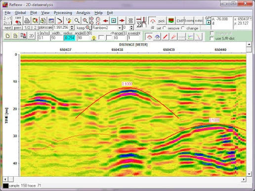
- Interactive Velocity Analysis: Precise velocity estimation using hyperbola adaptation on diffraction points, first-arrival analysis, dynamic semblance analysis, Constant Velocity Panels (CVP), and Common Mid-Point (CMP) / shot gather analysis for both reflection and refraction regimes.
- Reflex2DQuick & Streamlined Workflows: Integrated quick-look utility enabling field technicians to rapidly import, filter, correct topography, and visualize 2D GPR profiles or seismic shot records on-site within seconds.
- Advanced 3D Data Cube Interpretation (Reflex3DScan): Interpolates parallel, perpendicular, or randomly distributed 2D survey profiles into unified 3D data volumes. Features dynamic X, Y, and Z time-slices, depth slicing, isosurface extraction, and interactive 3D cube navigation with direct spatial overlay onto digital maps.
- 3D Fixed-Array & Multi-Channel Support: Specialized handling tools for multi-channel GPR arrays, allowing rapid, synchronized navigation between individual profile channels and interpolated plan-view depth slices.
- Complete Seismic Refraction Inversion: Advanced refraction interpretation routines featuring manual/automated first-arrival picking, traveltime combination, Finite-Difference (FD) wavefront inversion, Generalized Reciprocal Method (GRM), and network ray-tracing.
- Traveltime Tomography (SIRT): Robust 2D/3D tomographic inversion engine based on the Simultaneous Iterative Reconstruction Technique (SIRT) for refraction traveltimes and transmission data (crosshole GPR and crosshole seismics), supporting both straight and curved raypaths.
- Borehole & Crosshole Methods: Specialized processing modules for Vertical Seismic Profiling (VSP), Walkaway VSP, multi-angle crosshole tomography, and borehole radar tomography.
- Finite Difference (FD) Forward Modeling: Numerical simulation of electromagnetic (Maxwell) and elastodynamic (acoustic/elastic) wave propagation in 2D heterogeneous media, generating realistic synthetic radargrams and seismograms to validate complex subsurface interpretations.
- Multi-Layer Horizon Picking & Vector Export: Interactive manual, semi-automatic, and automatic layer picking tools with direct export capabilities to ASCII, XYZ, and CAD-ready DXF vector files for integration into civil and GIS models.