As we work to modernize Jakarta, we face a massive challenge right beneath our feet. Our city is moving essential services underground to clean up the skyline and build better Integrated Utility Networks. However, mapping the utilities beneath Jakarta’s sidewalks is incredibly difficult. Our pedestrian paths are notoriously narrow, often blocked by trees, streetlights, and uneven curbs.
When we try to bring in standard 3D mapping equipment to locate hidden pipes and cables, we quickly realize that the machines are simply too large. Many competitor systems and standard mapping carts are wide, heavy, and require wide-open spaces or vehicle towing to function properly. We cannot fit these large machines onto a standard, congested Jakarta sidewalk. If we cannot map the area, our construction teams are forced to guess where the old pipes are, leading to dangerous utility strikes, water leaks, and project delays.
We need a tool that fits our environment. We need a Compact 3D GPR Array.

Ground-penetrating radar (GPR) is a geophysical method that uses radio waves, typically between 30 and 3000 MHz, to non-destructively map the subsurface without any excavation. By sending short pulses into the ground and recording the reflections, we can see exactly what is buried below. Today, we have access to advanced multichannel 3D GPR arrays that capture a continuous, high-resolution volume of data in a single pass.
For our narrow urban environments, the MALÅ MIRA Compact is the exact solution we need. Here are the top reasons why we must use this specific Compact 3D GPR Array for our sidewalk utility mapping projects in Jakarta.
1. The Perfect Size for Narrow Sidewalks (0.6-Meter Swath)
The biggest advantage of the MIRA Compact is its physical size. While standard 3D GPR solutions, like the MALÅ MIRA HDR, are built for everyday mapping on wide roads and feature a 1.4-meter wide coverage path, we cannot use something that wide on a tight pedestrian walkway.
|
Feature |
Standard 3D GPR |
MALÅ MIRA Compact |
|
Swath Width |
1.4 Meters or more |
0.6 Meters |
|
Mobility |
Vehicle-towed |
Hand-push (Manual) |
|
Operational Area |
Highways / Open Areas |
Narrow Pavements & Confined Spaces |
|
Processing Time |
Hours to Days |
Minutes (Offline) |
The MALÅ MIRA Compact solves this space problem entirely. It delivers the exact same high-resolution data as the larger systems, but it comes in a much smaller and highly portable format. This system features an effective swath coverage of exactly 0.6 meters. Because it is less than a meter wide, we can easily navigate it between streetlamps, planters, and narrow property boundaries. The Compact solution is specifically designed for hand-pushed surveys, allowing our operators to walk it smoothly down any restricted Jakarta sidewalk. We no longer have to turn down mapping jobs or switch to inaccurate single-line radars just because the work area is narrow.
2. We See Everything in True 3D
When we use older, simple mapping tools, we often miss critical information. Traditional single-line GPR forces us to walk back and forth in a grid, and then we have to guess what happens in the blank spaces between our walking lines.
The MIRA Compact is a multichannel 3D GPR array. This means it uses a unique data channel geometry to collect true, one-pass 3D data. As we push the 0.6-meter wide cart down the sidewalk, it captures a dense, continuous 3D image of the ground beneath it,. We do not have to guess what lies hidden in the subsurface. This technology reveals the exact layout, depth, and direction of the utilities, giving us the confidence we need to plan safe excavation routes for new cables.
3. Finding Both Metal and Plastic Pipes
One of the biggest risks during urban excavation is hitting a non-metallic pipe. Traditional cable locators only beep when they detect metal. They are completely blind to PVC water mains, concrete sewer lines, or fiber optic ducts. If we only map the metal, we leave our construction crews at high risk.
Because our Compact 3D GPR Array uses radio waves to record reflections from different materials, it detects changes in the physical properties of the ground itself. This allows us to accurately locate and map both metallic and non-metallic utilities in these complex environments. By clearly identifying the plastic water lines and the concrete drainage pipes alongside the power cables, we dramatically reduce the risk of utility strikes and support much safer excavation.
4. Flexible Setup for Any Ground Condition
Jakarta’s sidewalks are not perfectly smooth. Sometimes we map on paved asphalt, sometimes on broken concrete, and sometimes on soft dirt or grass. We need equipment that adapts to the surface we are investigating.
Guideline Geo designed the MALÅ MIRA system to adapt perfectly to our workflow. While the MIRA Compact is built for hand-pushing, it also supports vehicle-mounted operation using optional carrier solutions when we need to move off the sidewalk and onto the street. For example, we can use the MALÅ MIRA Compact Tow Hitch Carrier. When we use this carrier, we can easily adjust the equipment based on the ground surface.
If we are surveying over hard or abrasive surfaces like asphalt and concrete, we choose the “Air measurement” mode. This mode lifts the sensor to a 10cm clearance height, protecting the bottom of the expensive equipment from scraping against the rough road. On the other hand, if we are surveying on soft or forgiving ground like grass and soil, we switch to the “Ground measurement” mode. This mode lowers the sensor to sit at a -5cm clearance, pressing it close to the earth for maximum signal penetration. We simply measure the tow ball height of our specific vehicle and adjust the orientation of the height adjustment tower to make it fit perfectly. We can assemble the complete unit easily using the provided M12x40 bolts, washers, and nuts. This incredible flexibility ensures our system works efficiently, comfortably, and reliably across any terrain.
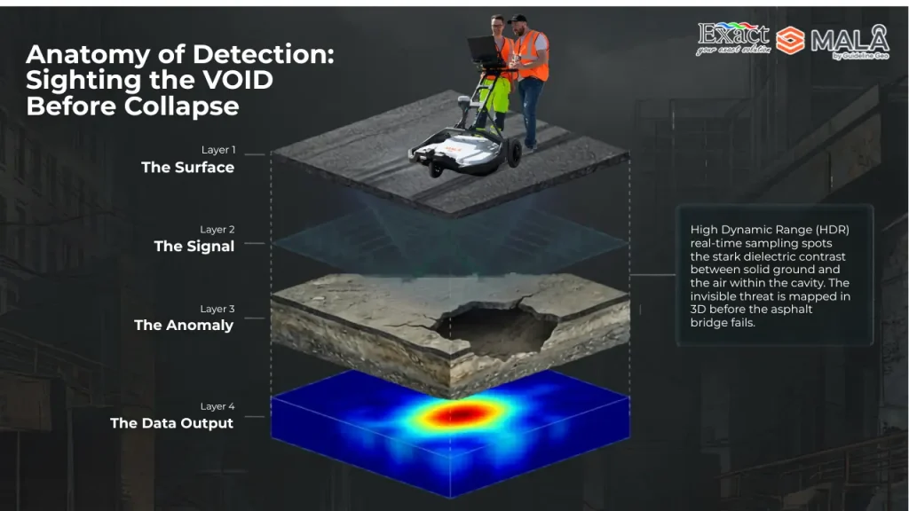
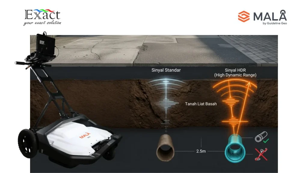
5. High Dynamic Range (HDR) for Clearer Images

Urban grounds are filled with debris, different soil layers, and closely packed utilities. This creates a noisy environment for radar signals. To see clearly, we need a strong, clean signal.
All MALÅ MIRA products, including the MIRA Compact, take full advantage of HDR (High Dynamic Range) real-time sampling technology. This technology delivers high-resolution subsurface imaging. By utilizing this advanced real-time sampling, we get an incredibly clear picture of the underground, cutting through the noise to show us exactly where the utilities are located. We do not have to settle for blurry, hard-to-read data.
6. Processing Data in Minutes, Not Hours
When we are working on a busy Jakarta street, we cause traffic and pedestrian disruptions. We need to finish our survey and deliver the safety map to the construction crew as fast as possible. We cannot wait days for a computer to process the files.
The MALÅ MIRA software suite is designed for ultimate speed. The MALÅ Vision Desktop is a fast and intuitive software built specifically for processing, analyzing, and reporting 3D GPR array data. The greatest advantage for our field teams is that this software runs entirely offline using local computer resources,. We do not need to rely on a slow internet connection to upload massive files to a cloud server.
Because it is optimized for large datasets, it delivers results in minutes rather than hours,. The software features automated processing and depth-slice generation, which heavily streamlines our workflows,. We get immediate visual feedback with multiple viewing modes, including map, 2D, and 3D views. Once the processing is complete, exporting our reports, depth slices, and interpreted objects is quick and straightforward using standard industry formats,.
7. Seamless Data Collection in the Field
Operating complex equipment on a crowded sidewalk can be stressful for our technicians. If the software is confusing, mistakes happen. To prevent this, Guideline Geo carefully developed the MALÅ MIRA Controller.
The MIRA Controller is a dedicated data acquisition software that we use while pushing the cart,. It offers a highly intuitive interface for channel configuration, data collection, and file management,. It also supports integration with different positioning systems, ensuring our underground maps are always tied to accurate GPS coordinates,. When we finish walking the sidewalk, the projects are seamlessly transferred from the MIRA Controller directly to the MALÅ Vision Desktop for processing,. The entire software solution guides us through the complete process, from the first step of survey planning all the way to final reporting.
8. Protecting the City from Hidden Sinkholes

Our job on the sidewalks goes beyond just finding pipes. Leaky water mains and poor soil compaction can wash away the ground beneath the pavement, creating hidden voids. If we do not find these voids, the sidewalk or the road next to it will eventually collapse.
We use the Compact 3D GPR Array to assess roadbeds and infrastructure for voids, layer thickness, and overall subsurface conditions. Early detection of sinkholes is crucial for supporting safer networks and ensuring long-term asset management. By actively mapping these hazards before they break the surface, we protect the public and save the city from expensive emergency repairs.
Mapping the utilities beneath Jakarta’s narrow sidewalks is no longer a guessing game. We do not have to accept the high risks of utility strikes just because traditional 3D GPR machines are too wide to fit our paths.
By using a Compact 3D GPR Array, specifically the MALÅ MIRA Compact, we get the perfect tool for the job. With its 0.6-meter swath, it easily navigates the tightest spaces while capturing true, high-resolution 3D data in a single pass. It spots both metal and plastic pipes, adapts to any ground surface, and uses offline software that processes the data in minutes. This is how we ensure that Jakarta’s infrastructure projects are safe, fast, and fully prepared for the future.
Frequently Asked Questions (FAQ)
What is a Compact 3D GPR Array?
A Compact 3D GPR Array is a small, portable ground-penetrating radar system that uses multiple antennas to collect a continuous 3D volume of data in a single pass. It uses radio waves to map buried objects without digging.
Why is the 0.6-meter swath important for Jakarta?
Jakarta’s sidewalks are often very narrow and crowded with obstacles like trees and streetlights. Traditional 3D GPR carts are too wide to fit. The MIRA Compact has an effective swath coverage of only 0.6 meters, allowing it to easily navigate and map these restricted pedestrian paths.
Can this small tool detect plastic pipes?
Yes. Unlike standard cable locators that only find metal, 3D GPR detects changes in the physical properties of the subsurface. This allows it to accurately map both metallic and non-metallic utilities, including plastic PVC pipes and concrete sewers.
Does processing the 3D data take a long time?
No. The system uses MALÅ Vision Desktop software, which runs entirely offline using local computer resources. It features automated processing that handles large datasets quickly, delivering full 3D results and depth slices in minutes rather than hours.
Can I use the Compact GPR on a rough road instead of a sidewalk?
Yes. While designed for hand-pushed sidewalk surveys, it can be mounted to a vehicle using a Tow Hitch Carrier. You can set the equipment to “Air measurement” mode, which lifts the sensor 10cm off the ground to protect it from scraping on hard, abrasive surfaces like asphalt.
Can this tool find sinkholes?
Yes. The Compact 3D GPR Array is highly effective at assessing ground conditions. It can identify subsurface voids and variations in layer thickness, allowing for the early detection of sinkholes before the ground collapses.
Does this equipment comply with the standards of the Jakarta Bina Marga Office (Dinas Bina Marga)?
Yes. Its high accuracy and capability to detect non-metallic pipes are instrumental in meeting the reporting standards for SJUT (Integrated Utility Sub-duct) utility mapping in Jakarta.
About PT. Exact Global Teknologi We are dedicated to bringing the most advanced technological solutions to infrastructure and utility projects. We understand the unique challenges of working in dense urban environments like Jakarta. For consultations, equipment inquiries, or to learn more about utilizing the Compact 3D GPR Array for your next sidewalk mapping project, please reach out to us:
- Website: www.exactglobal.co.id
- Email Marketing: marketing@exactglobal.co.id
- WhatsApp: +62 812-9252-3900